WHAT IS EARTH’S ATMOSPHERE MADE UP OF?

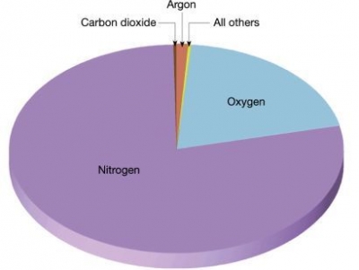
Covering the surface of Earth like a thin blanket is a layer of gases that forms the atmosphere. It is made up of 78 per cent nitrogen, 21 per cent oxygen and 0.04 per cent carbon dioxide. The minute, remaining percentage is made of some other gases, water vapour and dust. We barely notice this all-enveloping atmosphere, but without it the Earth would be lifeless as the Moon.

Earth’s atmosphere is composed of about 78% nitrogen, 21% oxygen, 0.9% argon, and 0.1% other gases. Trace amounts of carbon dioxide, methane, water vapor, and neon are some of the other gases that make up that remaining 0.1%. While the earth’s atmosphere is mainly gases, it also contains tiny particles such as dust and pollen. Some unnatural particles also collect in the atmosphere and cause air pollution. These include anything from aerosols to carbon emissions from vehicles and power plants.

As humans, we rely on the atmosphere around us for life. We breathe it, we live in it—without it, we wouldn’t survive. Not only does the atmosphere around us need to be made of a certain composition for us to thrive, but it also needs to be one in which plants and food can grow, and one that protects us from the elements. Having oxygen we can breathe is just as important as being protected from the harsh sun rays, or the open expanses of space, and Earth has just the right location and atmospheric chemical composition to sustain life for humans and all other life forms that call Earth home.
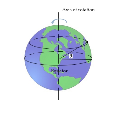
Credit: Worldatlas

Picture credit: Google

WHY DID IT TAKE SO LONG FOR LIFE TO APPEAR?

Earth’s surface was probably molten for many millions of years after its formation. Life did not exist for the first 400-800 million years, and first began in water after the forming of the oceans.

Life seems to have started on Earth almost as soon as the surface cooled off enough to make it possible. However, complex animal life—everything from insects to fish to humans - took a lot longer to show up. Given that modern animals are a phenomenally diverse group that evolved relatively quickly, why were they so slow to get going?

The answer may be that animals are greedy: they need a lot of oxygen to grow big and complicated. Early Earth didn’t have much oxygen, but microbes changed the chemical content of the atmosphere over time from something alien and poisonous to us into the breathable air we have today. A new paper showed that the oxygen level as recently as 800 million years ago was only a tiny fraction of today’s - far too low to support oxygen-breathers like our ancestors and their relatives.

Life on Earth has always belonged mainly to microorganisms. Clouds are full of microbes; they have been found in deep mines and on the ocean floor. They outnumber and may even outweigh all other forms of life. If all animals vanished, most bacteria would still live on, but if all bacteria disappeared, we would die quickly.

The history of life on Earth reflects this as well. The first single-celled organisms appeared about 3.8 billion years ago, while the first known multi-cellular organisms evolved 2.1 billion years ago. However, these were “primitive” in our human-centric eyes: they didn’t have specialized organs for breathing or eating, much less brains for the wasteful activity we call “thinking”.

Then in the Cambrian era, around 570 million years ago, recognizably complex animal life evolved, including vertebrate ancestors. This change was relatively rapid in evolutionary terms, and a lot of diverse critters came out of it. Thus, something significant must have changed between 2.1 billion years and 570 million years to let animals diversify and complexity.

To explain this great change, scientists consider several possible explanations. One environmental (as opposed to genetic) idea: animals breathe in oxygen, so there needs to be enough oxygen in the air and water. Corals, sponges, and the like require less oxygen than crabs or fish, so oxygen levels limit what sorts of animals can evolve in a particular environment.

Credit: Daily Beast

Picture credit: Google

WHAT IS A WOOLLY MAMMOTH?

Woolly mammoths were closely related to today's Asian elephants. They looked a lot like their modern cousins, except for one major difference. They were covered in a thick coat of brown hair to keep them warm in their home on the frigid Arctic plains. They even had fur-lined ears. 

Their large, curved tusks may have been used for fighting. They also may have been used as a digging tool for foraging meals of shrubs, grasses, roots and other small plants from under the snow.

Though woolly mammoths went extinct around 10,000 years ago, humans know quite a bit about them because of where they lived. The permafrost of the Arctic preserved many woolly mammoth bodies almost intact. When the ground around riverbanks and streams erodes, it often reveals the corpse of a long-dead mammoth that looks much like it did when it died.

Woolly mammoths were around 13 feet (4 meters) tall and weighed around 6 tons (5.44 metric tons), according to the International Union for Conservation of Nature (IUCN). Some of the hairs on woolly mammoths could reach up to 3 feet (1 m) long, according to National Geographic.

Credit: Live Science

Picture credit: Google

WHAT ARE STROMATOLITES?

Primitive life forms may have first appeared on Earth about 3800 million years ago. These bacteria lived in the oceans and built up solid mats of calcium carbonate, also known as lime. The deposits from the bacteria are known as stromatolites.

Stromatolites are living fossils and the oldest living lifeforms on our planet. The name derives from the Greek, stroma, meaning “mattress”, and lithos, meaning “rock”. Stromatolite literally means “layered rock”. The existence of these ancient rocks extends three-quarters of the way back to the origins of the Solar System.

With a citizen scientist’s understanding, stromatolites are stony structures built by colonies of microscopic photosynthesising organisms called cyanobacteria. As sediment layered in shallow water, bacteria grew over it, binding the sedimentary particles and building layer upon millimetre layer until the layers became mounds. Their empire-building brought with it their most important role in Earth’s history. They breathed. Using the sun to harness energy, they produced and built up the oxygen content of the Earth’s atmosphere to about 20%, giving the kiss of life to all that was to evolve.

Living stromatolites are found in only a few salty lagoons or bays on Earth. Western Australia is internationally significant for its variety of stromatolite sites, both living and fossilised. Fossils of the earliest known stromatolites, about 3.5 billion years old, are found about 1,000km north, near Marble Bar in the Pilbara region. With Earth an estimated 4.5 billion years old, it’s staggering to realise we can witness how the world looked at the dawn of time when the continents were forming. Before plants. Before dinosaurs. Before humans.

Credit: bbc.com

Picture credit: Google

WHEN DID PLANTS START TO GROW ON LAND?

The first land plants appeared during the Silurian period, around 440 million years ago. These simple plants reproduced by releasing spores. Plants produced oxygen and provided food for the first land animals - amphibians. Amphibians first developed in the Devonian period, 420 million years ago, from fish whose fins evolved into limbs.

Botanists now believe that plants evolved from the algae; the development of the plant kingdom may have resulted from evolutionary changes that occurred when photosynthetic multicellular organisms invaded the continents. The earliest fossil evidence for land plants consists of isolated spores, tracheid-like tubes, and sheets of cells found in Ordovician rocks. The abundance and diversity of these fossils increase into the Silurian Period (about 443.8 million to 419.2 million years ago), where the first macroscopic (megafossil) evidence for land plants has been found. These megafossils consist of slender forking axes that are only a few centimetres long. Some of the axes terminate in sporangia that bear trilete spores (i.e., spores that divide meiotically to form a tetrad). Because a trilete mark indicates that the spores are the product of meiosis, the fertile axes may be interpreted as the sporophyte phase of the life cycle.

Fossils of this type could represent either vascular plants or bryophytes. Another possibility is that they are neither but include ancestors of vascular plants, bryophytes, or both. The earliest fossils also include at least one or more additional plant groups that became extinct early in the colonization of the land and therefore have no living descendants. By the early Devonian Period (about 419.2 million to 393.3 million years ago), some of the fossils that consist of forking axes with terminal sporangia also produced a central strand of tracheids, the specialized water-conducting cells of the xylem. Tracheids are a diagnostic feature of vascular plants and are the basis for the division name, Tracheophyta.

Credit: Britannica

Picture credit: Google

WHAT IS THE TIMELINE OF LIFE ON EARTH?

Just as the day is divided into hours, minutes and seconds, geologists divide Earth’s history into time periods. The longest divisions are aeons, which are billions of years long; the shortest are chrons, a few thousand years long. In between come eras, periods, epochs and ages. Scientists divide the last 590 million years into three eras: the Palaeozoic (meaning ‘old life’), Mesozoic (‘middle life’), and Cenozoic (‘new life’).

Humans have only been a species in the most recent chapter of the history of Earth. The Earth was formed 4.6 billion years ago, when the sun in our solar system first formed, creating enough gravitational pull to spin planets into orbit. But how do scientists know how old the Earth is if humans weren't around back when it was formed? When was life first formed on this planet? And what are the paths that life has taken so far over the course of that existence? This lesson will teach about the ages that make up the history of life on Earth, and explore the many changes and forms life has taken in its time on this planet.

Timeline of Geological Eras

The geological timeline of Earth is nearly identical to the history of life on Earth, apart from the Hadean Era. This is because the geological timeline, or the order of geological events, such as oceans forming, volcanoes erupting, how long deserts lasted, and tectonic plate movement, all happened in sequence with the life that has existed on this planet. The history of both life and the geological timeline is arranged within 5 subgroups, arranged from the largest span of time to the smallest: eons, eras, periods, epochs, and ages. To understand the timeline of life that has existed on Earth, it is important to understand how scientists determine the age of both rocks and the remnants of living things, otherwise known as fossils.

Because humans were not around 4.6 billion years ago to record the beginnings of our planet, scientists must rely on evidence from geological and fossil records in order to determine the relative age of both the planet and the life that exists here. Both the geological timeline and the age of life are determined in much the same way. Modern scientists rely on what is called radioactive dating to determine an accurate and precise age of both rocks and fossils. Radioactive dating measures the rate of decay of an element in a rock or in a fossil. Carbon-14 is typically used when dating fossils because all living things are carbon-based, and the flow of carbon can be tracked through the carbon cycle. For geological objects such as rocks and minerals, Rubidium-87 and Potassium-40 are often used. By knowing how long it takes for molecules in an object to decay, scientists can calculate when the object's half-life is. The half-life of an object refers to the amount of time it would take for half of an amount of a substance to radioactively decay, or break down. If the half-life of an object is known, it is possible to calculate when the object was first created, when no decay is evident.

Credit: study.com

Picture credit: Google

HOW MANY HOURS ARE THERE IN A DAY?

Our system of telling time is based on the premise that every day is exactly 24 hours long — quite precisely, with no exceptions. This concept is fully ingrained into our culture, a core principle of our modern technological society. At the same time, we are taught in school that a day corresponds to one complete rotation of the Earth on its axis. Unfortunately, these two concepts don’t quite match up — and the mismatch is more than just a few milliseconds. In fact, the mismatch amounts to several minutes every day. Furthermore, because our traditional concept of a “day” is actually defined by the cycle of sunlight and darkness — and not by one rotation of the Earth — the length of a real day is not consistent, but varies somewhat during the year. We only pretend that all days are the same length — by averaging the length of all the days in the year, and then defining this average as a “standard day” of exactly 24 hours.

This is not a bad thing. In fact, it has been quite helpful to define our system of time in this manner. But once you understand why this system does not quite match up with the real world, then you can begin to make sense of several interesting phenomena. For example, you would think that the earliest sunset and the latest sunrise would both occur on the shortest day of the year, which is the first day of winter. But this is not the case at all.

If our definition of a day was truly based on one complete rotation of the Earth on its axis — a 360 degree spin — then a day would be 23 hours, 56 minutes, and 4 seconds. This is nearly 4 minutes shorter than our 24-hour standard day. However, our concept of a “day” has long been based on the natural cycle of sunlight — a period of daylight followed by a period without daylight. The mismatch of nearly 4 minutes is because the Earth must rotate more than 360 degrees between one dawn and the next. As you know, the Earth experiences two simultaneous motions — it not only spins on its axis, but it also travels in orbit around the sun. In a period of one day, the Earth travels about 1/365 of the way around the sun (because it takes about 365 days to go all the way around, which is how we define a year). This daily progress in the Earth’s orbit is almost exactly a degree (defined as 1/360 of a circle). Therefore the Earth has to spin an extra degree in order to line up with the sun again each day. The result is that one complete cycle of sunlight and darkness — one day — represents a rotation of about 361 degrees, not 360 degrees. Although a year consists of 365 and a quarter days, the Earth actually spins 366 and a quarter times during a year. From the standpoint of sunrises and sunsets, one complete spin is negated each year by the journey around the sun.

Credit: medium.com

Picture credit: Google

WHY DOES THE SUN RISE IN THE EAST?

Because Earth is spinning eastwards, the Sun comes up from the ground in the east, and sinks in the west.


Most people know that the Sun "rises in the east and sets in the west". However, most people don't realize that is a generalization. Actually, the Sun only rises due east and sets due west on 2 days of the year -- the spring and fall equinoxes! On other days, the Sun rises either north or south of "due east" and sets north or south of "due west."

Each day the rising and setting points change slightly. At the summer solstice, the Sun rises as far to the northeast as it ever does, and sets as far to the northwest. Every day after that, the Sun rises a tiny bit further south.

At the fall equinox, the Sun rises due east and sets due west. It continues on it's journey southward until, at the winter solstice, the Sun rises are far to the south as it ever does, and sets as far to the southwest.

Many, if not most, prehistoric cultures tracked these rising and settings points with great detail. If they had jagged mountains along the horizon, the exact points could be readily remembered. Without a suitably interesting horizon, standing stones could be arranged to line up with the various rising and setting points. Or, tree poles could replace the standing stones. Or, rock cairns could be used.

Credit: Stanford Solar Centre

Picture credit: Google

WHERE IS THE ANTARCTIC CIRCLE?

The Antarctic Circle is a parallel of latitude on the Earth at approximately 66.5 degrees south of the equator. On the day of the southern summer solstice (around December 22 each year), an observer on the Antarctic Circle will see the Sun above the horizon for a full 24 hours.

Observers further south than the Antarctic Circle will see the Sun remain above the horizon for many days, and at the South Pole, there is a six-month ‘day’ that starts on the autumnal equinox changing to a six-month ‘night’ on the vernal equinox.

The 66.5 degree angle comes from the tilt of the Earth’s rotation axis (23.5°), such that 90° – 23.5° = 66.

Credit: Cosmos

Picture credit: Google

WHERE IS THE ARCTIC CIRCLE?

The Arctic Circle is a line of latitude that circles the Earth at approximately 66° 33' 47.2" north of the Equator. How was that strange number determined? The position of the Arctic Circle is at the latitude above which the sun does not set on the summer solstice and does not rise on the winter solstice.

This is what causes the Arctic to have a very long continuous night each year and a very long continuous day. The length of these long continuous days and nights are six months each at the North Pole. Their length decreases with distance from the North Pole.

The latitude of the Arctic Circle is slowly drifting northward at a speed of about 15 meters per year. On July 2, 2018 it was at approximately 66° 33' 47.2" north of the Equator. This drift has nothing to do with climate change. Instead, the drift occurs because the Earth wobbles on its axis of rotation in a 40,000 year cycle in response to the gravitational attraction of the moon.

To most of the general public, using the Arctic Circle as the defining southern boundary for "the Arctic" is easy and makes total sense. However, some researchers believe that there are better ways to draw a map of the Arctic.

Credit: geology.com

Picture credit: Google

WHAT IS THE EQUATOR?

The equator is the circle that goes round the centre of Earth. It is perpendicular to the axis and divides the planet into two equal hemispheres (or half-spheres), the Northern and the Southern.

The Earth's Equator is the imaginary line that runs around the centre of the globe at 0 degrees latitude, at equal distance between the North and South Poles. Like the other lines of latitude, it's based on the Earth's axis of rotation and its orbit around the sun. It is the longest of Earth's five circles of latitude, the others being the polar circles, and tropical circles. This is because of how the Earth bulges around its centre.

The Equator is just under 25,000 miles long, wrapping around the entire Earth. The Equator divides the Earth into northern and southern hemispheres, with both experiencing different amounts of daylight at different times. This, weather, climate and the seasons we experience are a result of the Earth's tilt on its axis and its orbit around the sun. The northern and southern hemispheres are either turned toward or away from the sun depending on the Earth's position whilst it's orbiting the sun.

When the Sun is directly above the Earth's Equator, sunlight shines perpendicular to the Earth's axis, and all latitudes have a 12-hour day and 12-hour night. The Sun passes directly over the equator twice a year, on the March and September equinoxes.

Credit: twinkl

Picture credit:  Google

WHY ARE LATITUDE AND LONGITUDE IMPORTANT?

Two points on Earth can lie at the same latitude but still be far away from each other. Similarly, two distant points may lie on the same longitude. But only one point lies on a particular combination of latitude and longitude. So latitudes and longitudes are necessary for locating an exact point on Earth.

The importance of longitude and latitude are:

  • Latitudes help in identifying and locating major heat zones of the earth.
  • Latitude measures the distance between the north to south from the equator.
  • Latitude helps in understanding the pattern of wind circulation on the global surface.
  • Longitude measures the distance between the west to earth from the prime meridian.
  • Both longitude and latitude help us measure both the location and time using a single standard.
  • The lines of longitude and latitude help us in measuring the distance from the Earth’s Equator
  • Latitudes help us to find out the distance of any place from the Equator, which is base on its degree of latitude.
  • Longitude and latitude help us to find the location of any place on earth. These coordinates are what the Global Position System or GPS

Credit: Byju’s

Picture credit: Google

WHAT MAKES THE SEASONS?

Earth is always tilted the same direction as it orbits the Sun. So when Earth is on one side of the Sun, the northern hemisphere is tilted closer towards the Sun, making it warmer. At the same time, the southern hemisphere is tilted away from the Sun, and is, therefore, colder. When Earth reaches the other side of the Sun, it is the opposite, so it’s winter in the northern hemisphere and summer in the southern.

Seasons happen at different times in different parts of the world. The tilt of the Earth doesn’t change as it rotates around the Sun. But the part of the planet that gets the most direct sunlight does change.

The Northern Hemisphere is tilted away from the Sun from September to March. That means the northern half of the planet doesn’t get as much light and heat from the Sun. This causes autumn and winter. During the same months, the Southern Hemisphere is tilted towards the Sun. That means the southern half of the planet gets spring and summer.

From March to September, the Northern Hemisphere is tilted towards the Sun. So that’s when the northern half of the Earth experiences spring and summer. During the same months, the Southern Hemisphere experiences autumn and winter.
Other planets also have seasons. But the length and intensity of each season varies from planet to planet. 

  • On Earth, seasons last between 90 and 93 days. 
  • On Venus, seasons last between 55 and 58 days. 
  • On Mars, seasons change about once every six months. Summer lasts 199 days and winter lasts 146 days. 
  • On Saturn, seasons last about seven years. 
  • And if you lived on Neptune, you would have to wait more than 40 years for the seasons to change!

Credit: Let’s talk Science

Picture credit: Google

WHAT IS THE PRIME MERIDIAN?

This is an imaginary line of 0° longitude that is perpendicular to the equator, and parallel to the axis. It passes through Greenwich in the UK, and divides Earth into eastern and western hemispheres. As it crosses the poles to the opposite side of the globe, the line becomes 180° longitude and is also known as the International Date Line.

The prime meridian is arbitrary, meaning it could be chosen to be anywhere. Any line of longitude (a meridian) can serve as the 0 longitude line. However, there is an international agreement that the meridian that runs through Greenwich, England, is considered the official prime meridian.

Governments did not always agree that the Greenwich meridian was the prime meridian, making navigation over long distances very difficult. Different countries published maps and charts with longitude based on the meridian passing through their capital city. France would publish maps with 0 longitude running through Paris. Cartographers in China would publish maps with 0 longitude running through Beijing. Even different parts of the same country published materials based on local meridians.

Finally, at an international convention called by U.S. President Chester Arthur in 1884, representatives from 25 countries agreed to pick a single, standard meridian. They chose the meridian passing through the Royal Observatory in Greenwich, England. The Greenwich Meridian became the international standard for the prime meridian.

Credit: National geographic

Picture credit: Google

WHAT ARE LATITUDE AND LONGITUDE?

Every place on Earth’s surface can be pinpointed by two figures: its latitude and its longitude. Lines of latitude (called ‘parallels’) form rings around Earth, parallel to the equator. A place’s latitude is given in degrees (°) north or south of the equator, which is considered latitude 0°. On the other hand, lines of longitude (called ‘meridians’) run round Earth from north to south, dividing the world up like the segments of an orange.

A place’s longitude is given as degrees west or east of the prime meridian, which is longitude 0°. 

Latitude and longitude are angles that uniquely define points on a sphere. Together, the angles comprise a coordinate scheme that can locate or identify geographic positions on the surfaces of planets such as the earth.

Latitude is defined with respect to an equatorial reference plane. This plane passes through the center C of the sphere, and also contains the great circle representing the equator. The latitude of a point P on the surface is defined as the angle that a straight line, passing through both P and C, subtends with respect to the equatorial plane. If P is above the reference plane, the latitude is positive (or northerly); if P is below the reference plane, the latitude is negative (or southerly). Latitude angles can range up to +90 degrees (or 90 degrees north), and down to -90 degrees (or 90 degrees south). Latitudes of +90 and -90 degrees correspond to the north and south geographic poles on the earth, respectively.

Longitude is defined in terms of meridians, which are half-circles running from pole to pole. A reference meridian, called the prime meridian , is selected, and this forms the reference by which longitudes are defined. On the earth, the prime meridian passes through Greenwich, England; for this reason it is also called the Greenwich meridian. The longitude of a point P on the surface is defined as the angle that the plane containing the meridian passing through P subtends with respect to the plane containing the prime meridian. If P is to the east of the prime meridian, the longitude is positive; if P is to the west of the prime meridian, the longitude is negative. Longitude angles can range up to +180 degrees (180 degrees east), and down to -180 degrees (180 degrees west). The +180 and -180 degree longitude meridians coincide directly opposite the prime meridian.

Credit: WhatIs.com

Picture credit: Google