What is a keystone species?

A keystone species is one that has an incredibly important role to play in an ecosystem. Without this species, ecosystem would be dramatically different or may even stop existing altogether. It can be any organism, from large animals to microscopic bacteria. In short, a keystone species is what holds a habitat together.

There's a call to protect the tiger because as a keystone species, this top predator plays a significant role in the health and diversity of an ecosystem.

If it disappears, the population of its prey - usually ungulates - will go up, and this will result in the decimation of vegetation, leading to a collapse of the ecosystem.

Not just animals, birds and insects, even plants can be keystone species.

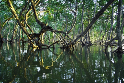
Mangroves are a keystone species that firm up shorelines and reduce erosion. They provide a safe haven and feeding area for small fish among their roots, which reach down through the shallow water.

It is true that if bees go extinct, so would humans. This keystone species plays a very important role in keeping the world going.

As the most important pollinators, they are responsible for about a third of the world's total food production. Without bees, there would be food shortage, and eventual human collapse.

Picture Credit : Google

Scientists believe this near-earth asteroid could actually be a fragment of our moon!

Researchers from the University of Arizona believe that Kamo'oalewa, a near-Earth asteroid, could well be a piece of our moon that broke off in the past. If that is indeed the case, it would make it the first asteroid known to have originated from the Earth's moon. These results have been published in a peer-reviewed paper in Communications Earth and Environment (Nature) in November.

Near-Earth asteroid

Kamo'oalewa is a near-Earth asteroid that is between 150-190 feet in diameter and gets as close as 14.5 million km to Earth. As a near-Earth asteroid, it is not part of the main asteroid belt between Mars and Jupiter, but instead, inhabits the inner solar system.

Even though it is very faint when viewed from Earth, astronomers managed to pick it up using their telescopes. While it looks like any near-Earth asteroid for the most part, its spectrum - the pattern of light reflected -was different from other asteroids.

Different spectrum

The spectrum of Kamo'oalewa suggested a silicate-based composition with reddening beyond what is seen in asteroids in the inner solar system, but rather matching with lunar silicates.

First discovered in April 2016, astronomers have been searching for an explanation for Kamo'oalewa for the past three years.

Using follow-up observations, they have now come to the conclusion that this asteroid could be made up of material from the moon. Additionally, the orbit of this asteroid is also similar to Earth's but slightly tilted, making it different from other near-Earth asteroids.

Along with the spectrum evidence, the tilted orbit further suggests that the asteroid came from the moon. And when that is proved beyond doubt, it would make Kamo'oalewa the first-ever asteroid that was actually once a piece of the moon.

Picture Credit : Google

What is on Easter Island?

On a small isolated island in the south eastern Pacific are scattered about 1,000 giant statues. Some weigh up to 90 tonnes and are 9.5m (32ft) tall. No one really knows how the Polynesians carved or raised these statues.

The island’s population represents the easternmost settlement of a basically Polynesian subgroup that probably derived from the Marquesas group. The original Rapa Nui vocabulary has been lost except for some mixed Polynesian and non-Polynesian words recorded before the Tahitian dialect was introduced to the decimated population by missionaries in 1864. Today Spanish is generally spoken. In their traditions, the islanders consistently divide themselves into descendants of two distinct ethnic groups, the “Long-Ears” and the “Short-Ears” (see below). Intermarriage is common, and an influx of foreign blood has become increasingly dominant in recent years.

Whereas the aboriginal economy was based on the cultivation of sweet potato, chicken raising, and coastal fishing, the island has shifted to a cash economy based on tourism. The opening of an airport at Mataveri near Hanga Roa has permitted an increasing influx of tourists since the 1960s, and a few small hotels have been built in the village area, where many islanders and settlers from continental Chile also have accommodations in their homes. The ties to continental Chile are strengthened through twice-weekly flights from Santiago and the building of schools, hospitals, and a large community hall for sports and performances. A well-organized Chilean national park system provides guided tours and security for the unique archaeological monuments. Reforestation projects have been successfully initiated, including eucalyptus plantations at Vaitea and coconut groves in Anakena Bay.

Credit :  Britannica 

Picture Credit : Google

Where is the land of the Midnight Sun?

Lapland is a region mainly inside the Arctic circle. It stretches across the north of Norway, Sweden and Finland.

This is the land of the Midnight Sun, which shines continually for 24 hours a day, for 73 days from mid-May to the end of July.

Lapland is a region of great topographical variety. To the west it embraces the northern part of the Kolen Mountains, which reach elevations of more than 6,500 feet (2,000 metres). On its Norwegian (western) side this range slopes abruptly and is deeply eroded into fjords and headlands and fractured into archipelagoes. The eastern flank of the range, which is situated in Swedish Lapland (see Lappland), slopes more gradually into a broad piedmont studded with large, fingerlike lakes that feed the rivers flowing into the Gulf of Bothnia. Farther to the east, Finnish Lapland (Lappi) is a relatively low-lying region with many bogs and small lakes.

Norwegian Lapland is largely open and windswept, with timber growth only in sheltered tracts and the more protected interior. Southern and central Lapland occupies the zone of the taiga, or swampy coniferous forest, with its saturated land and many bogs and swamps. Forests of pine and spruce give way to the dwarf birch, heath, and lichens of the tundra farther north and at higher elevations.

Many of the Sami have adopted a sedentary life and intermarried with Scandinavians and Finns. The region is still home to several hundred thousand reindeer, but the traditional reindeer country has been intruded upon by permanent farming, forestry, mining, and hydroelectric and even industrial enterprises. Those who practice reindeer herding have liberty of movement across the open boundaries of Finland, Norway, and Sweden.

Credit :  Britannica 

Picture Credit : Google

What is the career in the field of Earth Sciences?


Our Earth is extremely fragile, and human activities are making it more vulnerable. One of the recent examples of the impact of indiscriminate development and climate change is the shocking collapse of a portion of the Nanda Devi glacier in Uttarakhand's Chamoli district on February 7, 2021, and the ensuing floods that claimed many lives. The deadly disaster brings to light the need to rigorously study the impact of human activity on the environment. And that's exactly what earth scientists do.


What is Earth Science?


Earth science is the study of the structure, composition, and evolution of the Earth, the life it supports, and the processes that govern the formation and behaviour of the Earth's materials. It seeks to find answers to questions such as how ice moves, where the mineral resources are, and the rate of permafrost thaw. Understanding these phenomena is essential to the maintenance of life on the planet.


Different branches:


  • Glaciology: Glaciologists assess the impact of climate change, look for alternatives to sustain Earth's depleting resources, and forecast avalanches.

  • Geology: Geologists study Earth and the processes that act on its materials. It also traces the history of the planet and its life forms since origin.

  • Hydrogeology: The study of water flow on and below the Earth's surface and its chemistry.

  • Limnology: Limnology examines lake sediments to determine past climate and ecological environments.

  • Oceanography: The study of the ocean, including its water, boundaries and topography, types of currents, and marine biology.

  • Volcanology and Seismology: The scientific study of the dynamics of volcanoes and earthquakes.


What to study?


Universities in India and abroad offer a range of courses in Earth Sciences. You can pursue a Master of Science (M.Sc) and specialise in the field of your choice. A Ph.D is required to start working in the field.


Where: India


  • Wadia Institute of Himalayan Geology, Dehradun: Training and research programmes on Geomorphology and Environmental Geology. Geophysics, Petrology and Geochemistry

  • Indian Institute of Science Education and Research, Pune: Dual degree programme Bachelor of Science and Master of Science

  • Sharada University. Noida, and Pondicherry University: M.Sc in Environmental Sciences

  • Bharatiya Vidyapeeth, Insitute of Environment Education and Research. Punes M.Sc in Environment Science and Technology

  • Annamalai University, Cuddalore: M.Sc Earth Sciences and PG diplomas in Petroleum and Remote Sensing


Abroad


  • Utrecht University, the Netherlands, M.Sc Earth Surface and Water

  • University of Helsinki, Finland: M.Sc Geology and Geophysics

  • The University of Westent Australia: Master of Geographic Information Science

  • Massachusetts Institute of Technology, the U.S. M.SC Atmospheres, Oceans and Climate: M.Sc Geology, Geochemistry and Geobiology; Master of Environmental Policy and Planning


What are the job prospects?


Earth scientists primarily work in research organisations and environmental monitoring agencies.


These organisations could be in the private as well as the public sector.


Depending on your field of interest, you can also work with non-profit organisations and think-tanks on environment conservation and policy. If you have an academic bent of mind, then working in a university as a professor in the field of your choice could also suit you.


Picture Credit : Google


Are wind turbines a renewable energy source?


Whenever you have travelled, be it on buses or cars on road or by trains, you might have encountered vast open spaces that are rather windy. On most such spaces, you would have also seen wind farms - a term for an area "cultivated" with wind turbines.


The principle behind the workings of a wind turbine has been more or less the same through time. The turbine captures the wind's energy and converts it into a form we can use. Wind turbines have remained one of the most sophisticated forms of renewable energy, while at the same time being cost-effective as well.


Emerging trend


While this much is quite well-known, the trend in wind turbines over the years has been its increasing size. Even though there are a number of types of wind turbines, the horizontal axis kind - or the one that looks like a fan on a pole - remains the most popular ones. Highly efficient at converting wind energy to electrical energy, these wind turbines have been growing taller. From hub heights of about 30m in the 1990s, hub heights are now pushing past 100m.


Bigger the better


The reason for this is the fact that bigger is better for wind turbines. The way wind e travels around the world implies that velocities of wind at higher altitudes are way higher than that at ground level.


Apart from this feature, which allows these tall turbines to catch wind more easily, the larger, longer turbine blades also afford increased aerodynamic efficiency.


As with any large-scale projects, such wind turbines have their own set of challenges as well. But the technology and engineering acumen at our disposal would only mean that better solutions will keep emerging to harness more wind energy.


Picture Credit : Google


What is GPS map?


This accurate, up-to-date map is created using digital technology. You can view GPS maps on your phone, tablet, or computer. They can tell you exactly where you are at any time. The coordinates and position as well as atomic time obtained by a terrestrial GPS receiver from GPS satellites orbiting Earth interact together to provide the digital mapping programming with points of origin in addition to the destination points needed to calculate distance. This information is then analyzed and compiled to create a map that provides the easiest and most efficient way to reach a destination.


More technically speaking, the device operates in the following manner:


  • GPS receivers collect data from at least four GPS satellites orbiting the Earth, calculating position in three dimensions.

  • The GPS receiver then utilizes position to provide GPS coordinates, or exact points of latitudinal and longitudinal direction from GPS satellites.

  • The points, or coordinates, output an accurate range between approximately "10-20 meters" of the actual location.

  • The beginning point, entered via GPS coordinates, and the ending point, (address or coordinates) input by the user, are then entered into the digital mapping software.

  • The mapping software outputs a real-time visual representation of the route. The map then moves along the path of the driver.

  • If the driver drifts from the designated route, the navigation system will use the current coordinates to recalculate a route to the destination location.


Picture Credit : Google


What is political world map?


A political map shows you the countries of the world. You see where borders and cities are, including national capitals. Imaginary, numbered lines- the equator and lines of latitude and longitude – give you the exact position on Earth of places they pass through. Some of the largest independent nations in the world are the Russian Federation, People's Republic of China, the United States of America, Canada, Australia, India, Brazil, Saudi Arabia, and Argentina. While the smallest nations include Vatican City, Monaco, Andorra, and Singapore.


As represented on the world map, some countries like Brazil, Australia, the USA, and Indonesia have long coastlines, while others are completely landlocked like Bhutan, Switzerland, Mongolia, and Lesotho.


The world political map shows dependent territories such as Greenland and the Faroe Islands of Denmark, as well as the French Overseas Territories, which are geographically and culturally distinct, enjoying some degree of autonomy but are not independent states.


Picture Credit : Google


What is street map?


This type of map shows where the streets and roads in a town or city are. It will also show bus stops, stations, schools, hospitals, parks, and other useful and important places. The maps are of different sizes, shapes, and scales. Small maps are used to show the overview of a region’s major roads or routes while large maps give greater details and cover a large area. Highway maps give the overview of major routes within a region. Street maps mainly cover areas within a city or metropolitan area. A collection of road maps bound together in a book is referred to as road atlas. Road maps often use thin lines to indicate minor roads and thicker or bolder colors to indicate major roads.


Picture Credit : Google


What is physical map?


This type of map shows you the natural features in an area. These include mountains, volcanoes, rivers, lakes, seas, oceans, and deserts. Different colours and symbols are used to represent these features.


Continents:


The physical land mass of the world, the planet Earth, is divided into seven continents of Africa, North America, South America, Europe, Australia, Asia and Antarctica (It being the only uninhabited continent) . Asia with 29% of the world land mass is the largest and Australia with 5.9% of landmass the smallest. Mount Everest is the highest point on earth and Dead Sea the lowest.


Deserts:


Deserts occupy about 33% of the world land mass. Deserts, places on earth which have very little rainfall, can be either hot or cold. The largest cold deserts are the polar deserts of Antarctica and Arctic Circle. The largest sub tropical or hot deserts are the Sahara and Arabian Desert. Gobi and Kalahari are other large deserts.


Mountain ranges:


Mountains cover 24% of the earth land mass and are spread over all the continents. Asia has the largest area covered with mountains and Africa the least- only 3%. Himalayas, the Earth's youngest mountains are also the highest. These mountains are still growing. Mount Everest at 8848 meters is the highest peak and K2 at 8611 meters, the second highest. Alps are the mountain ranges in Europe and Rockies in North America.


Oceans:


Over two-third of the Earth's surface is covered with water and more than 97% of this water is contained in the oceans. The Pacific Ocean is the largest and deepest ocean in the world. The other oceans are Atlantic, Indian, Pacific, Southern and Arctic.


Lakes:


The earth is dotted with lakes-bodies of fresh or salt water surrounded by a land mass. Northern hemisphere has the majority of fresh water lakes. Aral Sea, Dead Sea, and Great Salt Lake are salt water lakes. Caspian Sea, if considered as a lake is the largest. Other large lakes are Lake Michigan in North America, Lake Victoria in Africa, and Lake Eyre in Australia.


Rivers:


Rivers are watercourses flowing towards oceans, seas, lakes or another river. The Nile River, in Africa, with a length of 6695 kilometers is the longest in the world. The Brahmaputra and the Ganges are rivers in Asia. The Colorado and the Mississippi are rivers in North America. The Amazon, the second largest river, is in South America. River Congo, in Africa is the deepest river though it is the ninth longest.


Picture Credit : Google