Which is the largest lake in Canada?

Great Bear Lake is located in the Northwest Territories. With a surface area of 31,328 km2, Great Bear Lake is the largest lake located entirely inside Canadian borders. It is also the fourth largest in North America and the eighth largest in the world. Water flows out of the lake into the Great Bear River, then into the Mackenzie River. Other rivers connected to the lake include the Dease, Camsell and Johnny Hoe. Great Bear Lake is made up of five separate arms, each with their own names: Dease, McTavish, McVicar, Keith and Smith.

The Dease Arm lies north of the Arctic Circle allowing for 24-hour daylight in summer. Great Bear Lake straddles the boundary between the Canadian Shield and the Interior Platform, as well as the northern boreal forest and tundra (see also Geological Regions; Forest Regions). The northeast shores of the lake feature sharp cliffs, numerous islands and fjord-like bays. By contrast, the southwest shores of the lake are flatter, with rich stands of spruce and large swaths of muskeg. The main elevation on this side of the lake is created by the Scented Grass Hills and Grizzly Bear Mountain.

The rivers surrounding Great Bear Lake drain nutrient-poor lands, which, combined with a small watershed, colder temperatures and considerable depth (at its deepest point, Great Bear Lake reaches 452 metres), mean the lake supports relatively few plant and fish species. Of Canada’s large lakes, Great Bear Lake has the fewest number of different fish species (only 16). Because the fish do not migrate much within the lake, its five arms are home to unique populations.

Credit : The Canadian Encyclopedia 

Picture Credit : Google

Which country has most number of natural lakes?

Canada, the second-largest country on Earth after Russia, has the most number of natural lakes in the world. There are over 31,700 big lakes in Canada, making its surface area covered by lakes more than any other country in the world.

Canada features black-blue lakes, numerous rivers, majestic western mountains, rolling central plains, and forested eastern valleys. The Canadian Shield, a hilly region of lakes and swamps, stretches across northern Canada and has some of the oldest rocks on Earth.

Canada's far north lies in the frozen grip of the Arctic, where ice, snow, and glaciers dominate the landscape. Few trees grow here, and farming is not practical. Native Canadians, called First Nations people, live in this region by hunting and fishing.

Canada's remote north and extensive forests are home to wildlife, from bears, wolves, beavers, deer, mountain lions, and bighorn sheep to smaller animals like raccoons, otters, and rabbits. The country's lakes and rivers, which contain about 20 percent of all fresh water on Earth, are full of fish such as trout and salmon.

Canada's prairies in the south are home to bison and pronghorn antelope. Farther north are Canada's sprawling evergreen forests, which have lots of wildlife, including moose and black bears. Even farther north is the cold, bare tundra, where herds of caribou and musk ox live.

Canadians work hard to protect the native wildlife. Canada has 41 national parks and three marine conservation areas. Nevertheless, species like wolves, lynx, and Atlantic fish have been overhunted and overfished.

Credit : Natural Geographic 

Picture Credit : Google

Which is the capital of Sierra Leone?

The capital of Sierra Leone is Freetown, which was founded 1787. Freetown has been the capital since 1961. Sierra Leone is bordered on the north and east by Guinea, on the south by Liberia, and on the west by the Atlantic Ocean.

The country can be divided into four distinct physical regions: the coastal swamp, the Sierra Leone Peninsula, the interior plains, and the interior plateau and mountain region. The coastal swamp region extends along the Atlantic for about 200 miles (320 km). It is a flat, low-lying, and frequently flooded plain that is between 5 and 25 miles (8 and 40 km) wide and is composed mainly of sands and clays. Its numerous creeks and estuaries contain mangrove swamps. Sandbars, generally separated by silting lagoons, sometimes form the actual coast. The Sierra Leone Peninsula, which is the site of Freetown, is a region of thickly wooded mountains that run parallel to the sea for about 25 miles (40 km). The Peninsula Mountains rise from the coastal swamps and reach some 2,900 feet (880 metres) at Picket Hill.

Inland from the coastal plain is the interior plains region. In the north it comprises featureless seasonal swamps known as “Bolilands” (boli being a Temne word for those lands that are flooded in the rainy season and dry and hard in the dry season and on which only grass can grow). In the south the plains comprise rolling wooded country where isolated hills rise abruptly to more than 1,000 feet (300 metres). The interior contains a variety of landforms ranging from savanna-covered low plains to rocky scarp and hill country. The interior plateau and mountain region, encompassing roughly the eastern half of the country, is composed mainly of granite with a thick laterite (iron-bearing) crust; to the west it is bounded by a narrow outcrop of mineral-bearing metamorphic rocks known as the Kambui Schists. Rising above the plateau are a number of mountain masses; in the northeast the Loma Mountains are crowned by Mount Loma Mansa (Mount Bintimani) at 6,391 feet (1,948 metres), and the Tingi Mountains rise to 6,080 feet (1,853 metres) at Sankanbiriwa Peak. Numerous narrow inland valley swamps associated with the river systems occur in this region.

Credit :  Britannica 

Picture Credit : Google

Which country is the roundest?

Sierra Leone in West Africa is the roundest country in the world. Famous for its sandy beaches, the country is rich in diamonds and other minerals. Its original Portuguese name Serra Lyoa means "Lion Mountains, referring to the hills surrounding one of the largest natural harbours in the world.

The Bulom people were thought to have been the earliest inhabitants of Sierra Leone, followed by the Mende and Temne peoples in the 15th century and thereafter the Fulani. The Portuguese were the first Europeans to explore the land and gave Sierra Leone its name, which means ?lion mountains.? Freetown, on the coast, was ceded to English settlers in 1787 as a home for blacks discharged from the British armed forces and also for runaway slaves who had found asylum in London. In 1808 the coastal area became a British colony, and in 1896 a British protectorate was proclaimed over the hinterland.

Sierra Leone became an independent nation on April 27, 1961. A military coup overthrew the civilian government in 1967, which was in turn replaced by civilian rule a year later. The country declared itself a republic on April 19, 1971.

A coup attempt early in 1971 led to then prime minister Siaka Stevens calling in troops from neighboring Guinea's army, which remained for two years. Stevens turned the government into a one-party state under the aegis of the All People's Congress Party in April 1978. In 1992 rebel soldiers overthrew Stevens's successor, Joseph Momoh, calling for a return to a multiparty system. In 1996, another military coup ousted the country's military leader and president. Nevertheless, a multiparty presidential election proceeded in 1996, and People's Party candidate Ahmad Tejan Kabbah won with 59.4% of the vote, becoming Sierra Leone's first democratically elected president.

Credit : Info Please 

Picture Credit : Google

Karak’s Fifa Nature Reserve registers as world’s lowest wetland

Spanning an area of more than 23 sq.km., the Fifa Nature Reserve is located in the southwestern part of Jordan. The wetland lies in the Jordan Rift Valley and is fed by several water sources from natural springs to seasonal floods. The lowest point in the Reserve stands at 420 mt below sea level, making it the "world's lowest wetland of international importance", according to the Ramsar Convention. Established in 2011, the Reserve's location in the Rift Valley makes it a significant spot supporting many species of wintering and breeding birds that migrate between Europe and Africa. It is important as one of the few remaining natural breeding habitats of Dead Sea sparrow" and is known to host the largest population of the Nubian nightjar. It also hosts the endangered killifish, houbara bustard, and the spiny tailed lizard. The Reserve is marked by saline vegetation, one of the several vegetation types of the country. The region is said to be home to a total of 4% of the country's plant species and 8% of animal species, including some that are endangered. Though the wetland is said to display semi-desert systems and high temperatures, the diverse flora and fauna seem to have adapted well to these seemingly difficult conditions.

Wildlife

The birds that can be seen in the Reserve are egrets, herons, bitterns, teals, mallards, garganeys, storks, pratincoles, snipes, redshanks, moorhens, stilts, plovers, lapwings, stints, sandpipers, ibises, grebes, falcons, finches, harriers. owls, shrikes, eagles, larks, doves, kestrels, warblers, sparrows, vultures, gulls, bulbuls, partridges, buzzards, gadwalls, terns, red knots, prinias, wheatears, rollers, bee-eaters, coursers, kingfishers, sunbirds, thrushes, nightjars, and bustards. Among the animals that one can spot in the area are lynx hyenas, deer, etc.

Lynx facts

  • Found in the forests of North America, Europe, and Asia, the lynx belongs to the cat family.
  • These carnivores can grow up to 40 inches long, but the sizes of the species vary depending on their geography. For instance, the Canadian lynx is smaller than its European cousins.
  • These mammals have thick fur, and their paws are furry too, both of which help them survive harsh winters. Their sharp sense of hearing and vision help them spot their prey even a few hundred feet away!
  • Though the lynx hunts small animals, deer, birds, squirrels, and mice, it feeds primarily on snowshoe hare. The change in the hare population, especially the decline, is believed to be affecting the cat population.
  • These cats are said be hunted by humans sometimes for their fur. One of the species, the Iberian lynx is said to be the most endangered cat.

Houbara bustard facts

  • Bustards are large, terrestrial birds, including some of the largest flying birds. They are listed as Vulnerable by the International Union for Conservation of Nature (IUCN).
  • The IUCN recognises two types of the houbara bustard - one in North Africa (Chlamydotis undulata) and the other in Asia (Chlamydotis macqueenii). At least 20,000 birds in each species exist today.
  • Asian houbara bustards are found from northeast Asia and central Asia to the Middle East, and the Arabian Peninsula.
  • The birds are faced with several threats - from habitat destruction to poaching and hunting.

Picture Credit : Google

Are aliens creating crop circles?

Have you heard of crop circles? They are strange patterns that crop up mysteriously overnight in farmers' fields. More than 10,000 crop circles have been reported around the world. But who creates them? It has been a puzzle and there has been little scientific study on crop circles.

There are many theories about what creates crop circles, including mysterious vortices, time travellers and wind patterns. The two most popular explanations are that they are the landing impression of a UFO (Unidentified Flying Objects) and that they are created by aliens, trying to send a message to the Earth dwellers. But all of these theories lack evidence.

The UFO theory has its origin in the story of a farmer in Tully, Australia. In 1966, he claimed he saw a flying saucer rise up from a swampy area and fly away. When he went to investigate he saw a crop circle, which, he assumed, was made by the alien spacecraft.

This came to be referred to as flying saucer nest by the media. Police investigation rubbished the farmer's claim, saying that the crop circle was created by natural phenomena such as a dust devil or waterspout.

Scientists who studied the crop circles in the 21st century believe that they are created by humans. In 2002, Jeremy Northcote, researcher who studied the crop circles in the U.K., said that the circles tended to appear near roads and cultural heritage monuments such as Stonehenge or Avebury - areas that are easy to access. He suggested that the circles were more likely to be caused by intentional human action than by paranormal activity.

The general scientific consensus on crop circles is that they are constructed by human beings as hoaxes or for advertising. There are also artists today who create crop circles as part of their art practice and for commercial clients.

Picture Credit : Google

What are atmospheric rivers?

Scientists have predicted that East Asia will experience extreme rainfall events due to climate change. In a new study published in Geophysical Research Letters, a research team led by the University of Tsukuba has reported that with a future scenario of 4 degrees of warming of global-mean surface air, these events are likely to become more frequent and intense in the future, especially in the mountainous parts of East Asia such as the Japanese Alps region.

The pouring rain will be brought on by a weather phenomenon called atmospheric rivers, scientists have reported. To reach their conclusions, the scientists ran simulations based on meteorological data collected from 1951 to 2010, modelling that data out to the year 2090.

Atmospheric rivers are long, flowing regions of the atmosphere that carry water vapour through the sky. They are about 250 to 375 miles wide and can be more than 1,000 miles long. The atmospheric rivers flow in the direction of moving air created by weather systems. They are also called rivers in the sky.

In general, they pick up water vapour from the warm, moist air of tropical regions and they drop the water over land in cooler regions as rain or snow. When one of these bands meets a barrier, such as a mountain range, it releases extreme levels of rainfall or snowfall in a short time. Precipitation from atmospheric rivers is thought to contribute about 20% of the Earth's total water flow. For some regions, increased rainfall will be a benefit for others, they could cause dangerous, life-threatening flooding. As the climate warms, there will be an increase in air moisture, which in tur means that atmospheric rivers are projected to become more intense, larger and carry higher volumes of water vapour.

The study authors have said that though their research focussed on Asia, their findings are likely applicable to other regions of the mid-latitudes where interactions between atmospheric rivers and steep mountains play a major role in precipitation, such as in western North America and Europe.

Picture Credit : Google

Has there ever been a wildfire in Antarctica?

Mention Antarctica and what immediately comes to mind are glaciers, icebergs, floes, penguins, and seals. But can you believe the icy continent experienced wildfires once upon a time? Yes, that is what a recent study reveals.

The fiery side

Antarctica was on fire 75 million years ago, according to a recent paper published by a team of international scientists in the journal Polar Research. Charcoal fossils were unearthed by researchers during a 2015-2016 expedition to the northeastern part of James Ross Island of Antarctica in the Southern Hemisphere. These charcoal remains are said to be the first recorded evidence of a paleo-fire (pre-historic fire) on the island. On analysing the fragments, the researchers found that they dated back to 75 million years and that they began their lives as ancient plants. The new research adds to existing studies that suggest Antarctica was once home to rainforests. The researchers who used imaging software and scanning electron microscopy to examine the charcoal remnants revealed that the fossils likely belonged to ancient coniferous trees.

Abundant vegetation

Antarctica has not always been covered in ice and snow, but has transformed into a frozen continent over millennia. According to the team of scientists led by the Federal University of Pernambuco in Brazil, the coal fossils hint at past forest fires in the region, giving credence to the presence of vegetation on Antarctica during the late Cretaceous period (lasting from 100 million to 66 million years ago). The Cretaceous Period was the last time dinosaurs roamed the Earth and it was also a period when disastrous wildfires tore through every continent.

Studies have revealed that the Gondwana ancient supercontinent started breaking up into huge landmasses about 180 million years ago with the continents of the present-day southern hemisphere drifting away during the late Cretaceous period because of the movement of tectonic plates. This left places such as Antarctica more isolated than before. Antarctica was ice-free and forested until about 55 million years ago. The ice-free region had several sources to spark fires, such as a lightning strike, a falling meteor, and volcanic activity. Researchers are now looking for further indications of paleo-fire around the virtually inhospitable Antarctica

Picture Credit : Google

What is Doomsday Clock? Who decides the time?

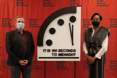
On January 20, 2022, the Bulletin of the Atomic Scientists announced that the Doomsday Clock was reset to 100 seconds (1 minute 40 seconds) before midnight. Midnight on the clock symbolises the end of the world. The decision came as a result of continued concern over nuclear weapons, climate change, the pandemic and the failure of governments and international organisations to respond in productive ways.

Over the years, the clock's hands have moved forwards and backwards as the threats to the world kept changing. From 2020, they have been 100 seconds to midnight due to threats from nuclear war, climate change and the pandemic. Why does this matter?

What is the Doomsday Clock?

The Doomsday Clock is a symbolic clock that represents the likelihood of a man-made apocalypse. It warns humanity of how close the world is to catastrophe every year. The concept is simple - the closer the time is to midnight, the closer the world is to destruction. The Doomsday Clock is a universally recognised metaphor.

How did the Doomsday Clock tradition begin?

The Doomsday Clock was created in 1947 in response to the growing threat of a nuclear war between the U.S. and the Soviet Union (today's Russia). The Clock's original setting then was seven minutes to midnight. The idea of the Doomsday Clock was conceived by an international group of researchers called the Chicago Atomic Scientists, who had been involved with the Manhattan Project, which made the first nuclear weapons. The scientists regularly brought out a bulletin detailing updates in nuclear weaponry. The board of the Bulletin of the Atomic Scientists (BAS) designed the clock as an illustration for the cover of the first edition of the bulletin. The Clock had been depicted on every cover of the bulletin until the publication became digital. The Clock is now featured as part of the logo on the bulletin's website.

Who decides the time?

The decision to move (or to leave in place) the minute hand of the Doomsday Clock is made every year by the Bulletin's Science and Security Board in consultation with its Board of Sponsors, which includes 13 Nobel laureates. The Board meets twice a year to reflect on international events considered dangerous to mankind and reset the clock accordingly every January.

What is the basis on which the time is set?

While climate change and the nuclear threat remain the main factors to determine the time, the panel of scientists in the bulletin also considers disruptive technologies such as cyber warfare, Artificial Intelligence and gene editing as potential threats. Biosecurity, bioterrorism, and dangers of fake news have also been considered. The bulletin considered possible catastrophic disruptions from climate change for the first time in 2007.

What is the reason behind the current time?

The scientists panel said that their decision was based on the war-like situation between Russia and Ukraine, the ongoing climate disaster and the coronavirus pandemic

The panel is concerned over the nuclear modernisation and expansion efforts of the U.S., Russia, China, and North Korea. "Ukraine remains a potential flashpoint, and Russian troop deployments to the Ukrainian border heighten day-to-day tensions," read the release from the Bulletin of the Atomic Scientists. As for climate action, it said there exists a huge gap still between long-term greenhouse gas-reduction pledges and emission-reduction actions needed to achieve those goals. It also said that the worldwide response against the COVID-19 pandemic in 2021 remained entirely insufficient. Plans for quick global distribution of vaccines essentially collapsed, leaving poorer countries largely unvaccinated and allowing new variants of the SARS-CoV-2 virus to gain an unwelcome foothold.

In view of this mixed threat environment, where positive developments are counteracted by worrisome trends, the members of the Bulletin of the Atomic Scientists find the world to be no safer than it was last year at this time.

Picture Credit : Google

Is Danakil Depression the hottest place on Earth?

The Danakil Depression in Ethiopia is scorchingly hot and one of the remotest places on Earth. Known as the "gateway to hell, it lies over 100 metres below sea level in a volcanic area. Though its air is toxic to humans, scientists have been able to find organisms living in the hot springs of the Depression.

One of the hottest places on earth (by average daily temperature) as well as one of the lowest (over 400 feet below sea level), the Danakil Depression entices three main types of people to the area: salt miners, scientists and travelers.

As they have done for centuries, miners travel hours — often by camel caravans — to extract salt slabs from the flat pans around Lake Afar. Salt is the region’s “white gold” and was a form of currency in Ethiopia until the 20th century. 

Scientists are attracted to the conditions. In the 1960s, the area was used to study plate tectonics, but more recently astrobiological exploration is the larger scientific draw.

In the spring of 2016, researchers from the University of Bologna, Italy’s International Research School of Planetary Sciences and Ethiopia’s Mekelle University studied whether microbes can withstand Danakil’s scorchingly inhospitable environment (it turned out they can). Scientists wonder whether if extremophiles, as they are known, can survive there, they can survive on Mars too.

Travelers are lured to the Danakil Depression for an altogether different reason. It’s a sweltering, foul-smelling, punitive place, which is exactly why people cross continents to see it. Despite its intensity, those who make the trek give it stellar reviews. 

The sulfur springs of Dallol are a particular draw, with its stupefying shades of neon green and yellow that hiss forth from the rocky terrain. Ethiopia’s most active volcano, Erta Ale (which means “Smoking Mountain” in the local Afar language) is another, with its cartoon-like molten center, one of only eight lava lakes in the world.

Credit : CNBC 

Picture Credit : Google

New tarantula species named after singer Johnny Cash

Did you know a black tarantula has been named after legendary American singer, songwriter and actor Johnny Cash? Scientifically called "Aphonopelma johnnycashi", this tarantula was discovered in 2015 near Folsom Prison, California. It was named after Cash in honour of his song Folsom Prison Blues."

The spider doesn't sing, but it's black and can be found near the California prison that was the setting of Cash's "Folsom Prison Blues."

The researchers also collapsed the number of U.S. species from 55 to 29, including Aphonopelma johnnycashi and Aphonopelma atomicum—named, with a wink to "Tarantula" and other sci-fi B movies, because it was collected near the atom bomb test site in Nevada.

"This is unequivocally the most important work on tarantulas ever done. It sets an incredibly high standard for taxonomy which few will be able to attain," Robert Raven of Australia's Queensland Museum wrote in an email after reading the paper.

The 340-page study by biologists Chris Hamilton and Jason Bond of Auburn University and Brent Hendrixson of Millsaps College "will be referenced for many many years," Raven said.

Credit : phy.org 

Picture Credit : Google

What effect do glaciers have on insect’s life?

One of the most obvious impacts of global warming has been melting glaciers. When we speak of glaciers melting, we invariably discuss how it could increase sea-levels or wipe off habitats, negatively affecting humans and large mammals such as polar bears. But the melting affects even tiny creatures such as insects.

The Rocky Mountains, spanning the U.S. and Canada, is home to the western glacier stonefly and the meltwater lednian stonefly.

Their habitat is the streams that flow from melting glaciers and snowfields of the region. But all is not well. Their habitats are shrinking, and their numbers, declining. Scientists say that by 2030, these insects are likely to lose about 80% of their habitat in Glacier National Park in the Rocky Mountains. These are rare insects and they "require several thousand acres of glaciers and snowfields if they are to survive a warming world that's threatening them with extinction. The threat to these stoneflies is an indication of how climate change affects mountaintop wildlife, many of which are still being explored. The case of these stoneflies, listed as threatened species in 2019, is of particular concern because they are mostly found in steep. remote areas that are hard to reach" Hearteningly, a "new draft recovery plan from the U.S. Fish and Wildlife Service suggests the possible transplant of some of the insects to new areas, exploring ways to artificially propagate populations and research into the stoneflies heat tolerance.

These are just two insect varieties, and why is there so much fuss over losing them to extinction? No matter what their size is or which part of the world they are in, insects have an impact on their surroundings. Just like all other creatures, they have unique ecological functions, and their absence gradually affects the plants, animals and even the humans around them. And the impact caused by the absence of these two rare insects will be no different.

Picture Credit : Google

India's Longest Expressway Is Finally Inaugurated

The Purvanchal Expressway was inaugurated by Prime Minister Narendra Modi at Kanwal Kheri in Sultanpur district in Uttar Pradesh on November 16, 2021. What's significant about it? Let's find out.

Six-lane expressway

The Purvanchal Expressway, at nearly 341 km in length, is at present the longest expressway in India. (An expressway is a wide road designed for high-speed traffic, usually having limited points of access or exit)

The Purvanchal Expressway is a six-lane access-controlled expressway that starts at Chand Sarai village located on Lucknow-Sultanpur road (National Highway 731) and ends at Hydaria village located on National Highway 31 in Ghazipur, 18 km east of the UP-Bihar border. This six-lane road can be expanded to eight lanes in the future.

Boost economic development

The expressway is expected to give a boost to the economic development of the eastern parts of UP. It connects as many as nine districts in the State-Lucknow (State capital), Barabanki, Amethi, Ayodhya, Sultanpur, Ambedkar Nagar, Azamgarh, Mau, and Ghazipur. Not just that, it establishes a direct road link between these districts and the national capital Delhi. The Expressway will reduce the travel time between Lucknow and Ghazipur by half-from 12 to six hours. It is expected to reduce fuel consumption and CO2 emissions. The Expressway has seven major bridges, 22 flyovers, 45 vehicular underpasses, toll plazas, and a 3. 3.2-km airstrip that would enable emergency landing and make-off of take-off f the IAF fighter planes.

The foundation stone for the Purvanchal Expressway was laid by PM Modi in July 2018 and the infrastructure project took three years to complete. Constructed by the Uttar Pradesh Expressways Industrial Development Authority at a cost of about Rs 22.500 crore, the Purvanchal Expressway is dubbed the 'carrier of development for the Purvanchal region.

Picture Credit : Google

What is the world's oldest capital?

Damascus, the capital of Syria, is the oldest capital and one of the oldest continuously-inhabited cities in the world, with evidence of habitation dating back to around 10,000 to 8,000 BCE. In 2018, its metropolitan area was home to about 2.3 million people, and in 2008 UNESCO named the city the Arab Capital of Culture. The city has some 125 monuments from different periods of its history, including the 8th century Umayyad Mosque or Great Mosque of Damascus, one of the largest and oldest mosques in the world.

The city exhibits outstanding evidence of the civilizations which created it - Hellenistic, Roman, Byzantine and Islamic. In particular, the Umayyad caliphate created Damascus as its capital, setting the scene for the city's ongoing development as a living Muslim, Arab city, upon which each succeeding dynasty has left and continues to leave its mark.

In spite of Islam's prevailing influence, traces of earlier cultures particularly the Roman and Byzantine continue to be seen in the city. Thus the city today is based on a Roman plan and maintains the aspect and the orientation of the Greek city, in that all its streets are oriented north-south or east-west and is a key example of urban planning.

The earliest visible physical evidence dates to the Roman period - the extensive remains of the Temple of Jupiter, the remains of various gates and an impressive section of the Roman city walls. The city was the capital of the Umayyad Caliphate. However, apart from the incomparable Great Mosque, built on the site of a Roman temple and over-laying a Christian basilica, there is little visible dating from this important era of the city's history. The present city walls, the Citadel, some mosques and tombs survive from the Middle Ages, but the greatest part of the built heritage of the city dates from after the Ottoman conquest of the early 16th century.

The line of the walls of the old city forms the boundary of the property. Although areas outside the walls that represent the expansion of the city from the 13th century, are considered related to the old city in terms of historical significance, and provide its setting and context, the key attributes of Outstanding Universal Value lie within the boundary. These include the plan of the city and its dense urban fabric, city walls and gates, as well as its 125 protected monuments including the Umayyad Mosque, madrasas, khans, the Citadel and private houses.

The attributes are vulnerable to erosion from a lack of traditional approaches to maintenance and conservation, and use of traditional materials, while its setting and context are threatened by lack of conservation policy for the historical zones outside the walled city and by regional planning projects.

Credit : UNESCO 

Picture Credit : Google

Where was the largest sapphire found?

The world's largest natural blue sapphire, named the "Queen of Asia", has been found in Sri Lanka.

The specialty of this sapphire is that it is comprised of aluminium oxide, titanium, iron, and nickel. The rare stone, weighing around 310 kg, was found in a gem pit in Ratnapura near the capital Colombo, and is estimated to be worth more than US$100 million. Ratnapura, popularly known as Gem City, is a major exporter of sapphires and other precious gems. In 2020, Sri Lanka earned roughly half a billion dollars from the export of gems, diamonds and other jewels.

A group of Buddhist monks chanted blessings for the gemstone before it was unveiled.

"I have never seen such a large specimen before. This was probably formed around 400 million years ago," said renowned gemmologist Gamini Zoysa.

Meanwhile, Thilak Weerasinghe, the Chairman of the National Gem and Jewellery Authority of Sri Lanka said "It is a special star sapphire specimen, probably the biggest in the world. Given the size and its value, we think it will interest private collectors or museums."

The country's local gems and jewellery industry body had reported that it had earned around half a billion dollars through the export of gems, diamonds, and other jewellery last year.

Credit : WION 

Picture Credit : Google