WHAT IS A BAYMOUTH BAR?

When the movement of waves deposits gravel and sand in a manner that prevents access to a bay, it builds up a baymouth bar. The existence of the bar creates a shallow lake known as a lagoon that is separated from the sea by a beach.

A baymouth bar is a depositional feature as a result of longshore drift. It is a spit that completely closes access to a bay, thus sealing it off from the main body of water. These bars usually consist of accumulated gravel and sand carried by the current of longshore drift and deposited at a less turbulent part of the current. Thus, they most commonly occur across artificial bay and river entrances due to the loss of kinetic energy in the current after wave refraction.

In most cases, a Sand Bypass System is built to prevent these bars forming across the entrance of man-made seaway's, eliminating the danger posed to commercial and recreational boat owners passing through.

credit: en-academic.com

Picture Credit : Google 

WHICH IS THE LARGEST BLOWHOLE?

The Kiama Blowhole is a blowhole in the town of Kiama, New South Wales, Australia. The name ‘Kiama’ has long been translated as “where the sea makes a noise”. It is one of the town's major tourist attractions. Under certain sea conditions, the blowhole can spray 50 litres of water up to 25 metres (82 ft) in the air, in quantities that thoroughly drench any bystanders. There is a second, less famous blowhole in Kiama, commonly referred to as the "Little Blowhole" by locals. It is much smaller than the other (called the "Big Blowhole"), but due to its narrow shape, it is more reliable than the Big Blowhole, and in the right conditions can be equally spectacular.

The blowhole attracts 900,000 tourists a year. Kiama Blowhole is just a few metres beyond the coastline. The "little blowhole" is located at the Little Blowhole Reserve, Tingira Crescent, Kiama, 2km south of the main blowhole.

The blowhole was formed from basalt lava flows approximately 260 million years ago and was first discovered by local Aboriginals who named it 'Khanterinte'. The blowhole was first written about by George Bass on 6 December 1797. Bass had captained a crew of six and set out on an open whaleboat to explore the south coast of Australia. He noticed the blowhole after anchoring his boat in a sheltered bay.

Credit: Wikipedia

Picture Credit : Google 

WHAT IS A TOMBOLO?

Tombolo, one or more sandbars or spits that connect an island to the mainland. A single tombolo may connect a tied island to the mainland, as at Marblehead, Mass. A double tombolo encloses a lagoon that eventually fills with sediment; fine examples of these occur off the coast of Italy. The shallower waters that occur between an island and the mainland are the loci of such features because sandbars form there.

Adam’s Bridge, which connected Sri Lanka (Ceylon) with India across the 33-mile (53-kilometre) wide Palk Strait, was formerly the world’s largest tombolo. It was destroyed several thousand years ago by a slight change in mean sea level, and only a chain of sandbanks that seriously hinder navigation exists there today.

Credit: Britannica

Picture credit: Wikipedia


DOES THE SEA WEAR AWAY LAND?

Sea waves constantly crash into coasts, crushing rocks and pebbles. Rising waves hurl small rocks onto seaside cliffs, eroding them or tearing away at their base until they collapse. Waves and water currents carry sand and gravel that can alter coastlines. The sea and its waves can certainly wear away the land.

Coastal erosion is the wearing away of the land by the sea often involves destructive waves wearing away the coast (though constructive waves also contribute to coastal erosion).

There are four main processes of coastal erosion. These are corrasion, abrasion, hydraulic action and attrition.

Corrasion is when destructive waves pick up beach material (e.g. pebbles) and hurl them at the base of a cliff. Over time this can loosen cliff material forming a wave-cut notch.

Abrasion occurs as breaking waves, concentrated between the high and low watermarks, which contain sand and larger fragments wear away the base of a cliff or headland. It is commonly known as the sandpaper effect. This process is particularly common in high-energy storm conditions.

Waves hitting the base of a cliff causes air to be compressed in cracks, joints and folds in bedding planes causing repeated changes in air pressure. As air rushes out of the cliff when the wave retreats it leads to an explosive effect as pressure is released. This process is supported further by the weakening effect of weathering. The material breaks off cliffs, sometimes in huge chunks. This process is known as hydraulic action.

Attrition is when waves cause rocks and pebbles to bump into each other and break up.

Credit: internet geography

Picture Credit : Google

HOW DID THE AMAZON RIVER GET ITS NAME?

The Spanish soldiers who explored the region for the first time in 1541 battled native female warriors who fought bravely. The name the invaders gave to the river came from the Persian hamazan, meaning ‘those who fight together’ - also used in Greek mythology for outstanding women warriors.

Before the conquest of South America, the Rio Amazonas had no general name; instead, indigenous peoples had names for the sections of the river they occupied, such as Paranaguazu, Guyerma, Solimões, and others.

In the year 1500, Vicente Yañez Pinzon, in command of a Spanish expedition, became the first European to explore the river, exploring its mouth when he discovered that the ocean off the shore was freshwater. Pinzon called the river the Rio Santa Maria de la Mar Dulce, which soon became abbreviated to Mar Dulce, and for some years, after 1502, it was known as the Rio Grande.

Pinzon's companions called the river El Río Marañón. The word Marañón is thought by some to be of indigenous origin. This idea was first stated in a letter from Peter Martyr to Lope Hurtado de Mendoza in 1513. However, the word may also be derived from the Spanish word maraña; meaning a tangle, a snarl, which well represents the bewildering difficulties that the earlier explorers met in navigating not only the entrance to the Amazon, but the whole island-bordered, river-cut, and indented coast of what is now the Brazilian state of Maranhão.

The name Amazon arises from a battle that Francisco de Orellana had with a tribe of Tapuyas where the women of the tribe fought alongside the men, as was the custom among the entire tribe. Orellana derived the name Amazonas from the ancient Amazons of Asia and Africa described by Herodotus and Diodorus.

Credit: New World Encyclopedia

Picture Credit : Google

HOW OLD IS THE NILE RIVER?

The Nile River flowing through Egypt could be six times as old as previously thought, according to a study which estimated it to have originated at least 30 million years ago. The study, published in the journal Nature Geoscience, assessed the links between the geographical and physical features — or topography — of the Nile River to the flow of molten rocks in the Earth’s mantle.

The researchers, including those from the University of Texas (UT) at Austin in the US, connected the tilted nature of the Nile’s topography to a conveyor belt of mantle rock pushing up against the Ethiopian Highlands in the south, and pulling the surface down in the north. This gentle gradient, they said, keeps the Nile on a consistent northward course from its beginning to the end. The study said the Nile would have turned west long ago — probably changing the course of history along with it — if it weren’t for the mantle movement keeping the river on course.

Picture Credit : Google 

WHAT IS HONEYCOMB WEATHERING?

When salt water that collects on the rough surface of rocks, or seeps into cracks, evaporates, it leaves behind salt crystals. Over time, these crystals alter the rock, forming hundreds and thousands of tightly joined pits called honeycombs that are a classic example of both physical and chemical weathering.

Honeycomb weathering occurs throughout the world, but the origin remains a matter of controversy. Wind erosion, exfoliation, frost shattering, and salt weathering have been proposed as explanations, although few attempts have been made to substantiate these hypotheses with chemical or mineralogical studies.

Chemical analyses and field observations indicate that honeycomb weathering in coastal exposures of arkosic sandstone near Bellingham, Washington, results from evaporation of salt water deposited by wave splash. Microscopic examination of weathered surfaces show that erosion results from disaggregation of mineral grains rather than from chemical decomposition. Thin walls separating adjacent cavities seem to be due to protective effects of organic coatings produced by microscopic algae inhabiting the rock surface. Cavity walls are not reinforced by precipitation of elements released by weathering, as has often been suggested at other locations. Honeycomb weathering develops rapidly and can be observed on surfaces that were planar less than a century ago.

Credit: Geo Science World

Picture Credit : Google 

What is the difference between weathering and Erosion?

Weathering is the result of rocks wearing down because of the actions of the forces of   nature. It is a natural process. During weathering, the rocks in their changed form remain in the same place - there is no movement of material. Erosion, on the other hand, happens when the broken-down rocks are carried away by water, ice, wind or gravity, and the remains are deposited far away from the place where the change initially happened.

Weathering and erosion are forms by which rocks are separated and moved from their unique location. They vary depending on whether a rock's location is changed: weathering debases a rock without moving it, while erosion diverts rocks and soil from their unique locations. Weathering frequently prompts erosion by making rocks separate into little pieces, which erosive forces would then be able to move away.

Primarily, the difference between erosion and weathering is that weathering happens to set up though erosion includes movement to another location. Both are brought about by quite similar factors such as wind, water, ice, temperature, and even natural activity. They can likewise happen together.

                            Erosion

                              Weathering 

Erosion refers to the displacement of the solids through wind, water, and ice.

Weathering refers to the decomposition of the rocks, soil, and minerals through direct contact with the atmosphere.

The eroded materials are displaced in the case of erosion.

The weathered materials are not displaced in the case of weathering.

The several types of erosion include water, wind, thermal, ice, and gravity erosion.

The several types of weathering include physical, chemical, and biological weathering.

Wind, ice, water, and human activities are some of the major causes of erosion.

Weathering is caused because of atmospheric factors like air pressure.

Credit: Vedantu

Picture Credit : Google 

HOW QUICKLY DOES LAND GET WORN AWAY?

Erosion is the geological process in which earthen materials are worn away and transported by natural forces such as wind or water. A similar process, weathering, breaks down or dissolves rock, but does not involve movement.

Erosion is the opposite of deposition, the geological process in which earthen materials are deposited, or built up, on a landform.

Most erosion is performed by liquid water, wind, or ice (usually in the form of a glacier). If the wind is dusty, or water or glacial ice is muddy, erosion is taking place. The brown color indicates that bits of rock and soil are suspended in the fluid (air or water) and being transported from one place to another. This transported material is called sediment.

Credit: National Geographic Society

Picture Credit : Google 

WHAT IS GROUNDWATER?

Rainwater seeps below the surface of the Earth and soaks the soil. When there is more water than the soil can absorb, it can seep even further down until it is surrounded by rocks, creating a kind of storage area, known as an aquifer. The water here is groundwater, and the upper level of water is called the water table.

Water that has travelled down from the soil surface and collected in the spaces between sediments and the cracks within rock is called groundwater. Groundwater fills in all the empty spaces underground, in what is called the saturated zone, until it reaches an impenetrable layer of rock. Groundwater is contained and flows through bodies of rock and sediment called aquifers. The amount of time that groundwater remains in aquifers is called its residence time, which can vary widely, from a few days or weeks to 10 thousand years or more. 

The top of the saturated zone is called the water table, and sitting above the water table is the unsaturated zone, where the spaces in between rocks and sediments are filled with both water and air. Water found in this zone is called soil moisture, and is distinct from groundwater.

Existing groundwater can be discharged through springs, lakes, rivers, streams, or manmade wells. It is recharged by precipitation, snowmelt, or water seepage from other sources, including irrigation and leaks from water supply systems.

Credit: National Geographic Society

Picture Credit : Google 

WHAT IS SCREE?

Loose rocks of roughly the same size littered on steep mountain slopes.

Scree is a collection of broken rock fragments at the base of a cliff or other steep rocky mass that has accumulated through periodic rockfall. Landforms associated with these materials are often called talus deposits. Talus deposits typically have a concave upwards form, where the maximum inclination corresponds to the angle of repose of the mean debris particle size. The exact definition of scree in the primary literature is somewhat relaxed, and it often overlaps with both talus and colluvium.

The formation of scree and talus deposits is the result of physical and chemical weathering acting on a rock face, and erosive processes transporting the material downslope.

There are five main stages of scree slope evolution: (1) accumulation, (2) consolidation, (3) weathering, (4) encroaching vegetation, and finally, (5) slope degradation.

Credit: Wikipedia

Picture Credit : Google 

HOW DO WE MEASURE CONTINENTAL DRIFT?

Satellite tracking stations were initially used to measure continental drift. At present, an accurate measurement can be done through GPS trackers. Radio telescopes also give an accurate reading.

Geologists in the early 1900's (and earlier) observed related fossil assemblages and rock groups on the margins of different continents separated by large oceans. Continental drift theory proposed that the continents were once contiguous. Measuring the distance across the ocean basins provided a distance of drift, but not a rate.

Scientists in the 1960's used magnetometers to survey the ocean floor (the magnetometers were retired sub-hunters from WWII). They observed parallel bands of seafloor with the same magnetic orientation and intensity. They noticed that the bands were symmetric on either side of large ridges in the oceans. Plate tectonics proposes that the continents are going along for the ride as oceanic crust grows and spreads from ridges. The scientists used radiometric dating to calibrate the magnetic bands with a magnetic reversal time scale.

We now have the distance that the continents are from each other, and ages for the bands of oceanic crust between them, so we can calculate a rate. For example, the oldest crust in the Atlantic is about 180 million years old, and it is found off the eastern margin of North America and the Western margin of Africa (~6000 km).

6000km/180 million years = ~3.3 cm/year (Averaged over 180 million years, this is a very rough calculation).

This is how fast Africa and North America have cruised apart on average over the last 180 million years.

Credit: UCSB Science Line

Picture Credit : Google

FROM WHERE IN THE SUPERCONTINENT DID ANTARCTICA BREAK AWAY?

Gondwana was an ancient supercontinent that broke up about 180 million years ago. The continent eventually split into landmasses we recognize today: Africa, South America, Australia, Antarctica, the Indian subcontinent and the Arabian Peninsula.

According to plate tectonic evidence, Gondwana was assembled by continental collisions in the Late Precambrian (about 1 billion to 542 million years ago). Gondwana then collided with North America, Europe, and Siberia to form the supercontinent of Pangea. The breakup of Gondwana occurred in stages. Some 180 million years ago, in the Jurassic Period, the western half of Gondwana (Africa and South America) separated from the eastern half (Madagascar, India, Australia, and Antarctica). The South Atlantic Ocean opened about 140 million years ago as Africa separated from South America. At about the same time, India, which was still attached to Madagascar, separated from Antarctica and Australia, opening the central Indian Ocean. During the Late Cretaceous Period, India broke away from Madagascar, and Australia slowly rifted away from Antarctica. India eventually collided with Eurasia some 50 million years ago, forming the Himalayan Mountains, while the northward-moving Australian plate had just begun its collision along the southern margin of Southeast Asia.

Credit: Britannica

Picture Credit : Google

WHAT IS CONTINENTAL DRIFT?

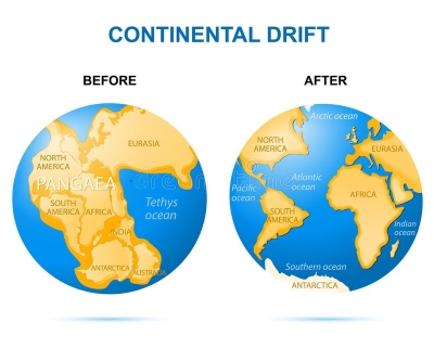
In the early 20th century, German scientist Alfred Wegener termed the movement over geological time of Earth’s major landmasses- Europe, the Americas, Africa, Australia, Asia and Antarctica- as ‘continental drift’. However, the modern day term is plate tectonics. Wegener suggested that landmasses may have pulled apart or pushed together to create new landforms. For example, he found evidence for this when he discovered fossils in Norway that indicated they originated in a tropical climate.

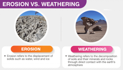
Continental drift describes one of the earliest ways geologists thought continents moved over time. Today, the theory of continental drift has been replaced by the science of plate tectonics.

The theory of continental drift is most associated with the scientist Alfred Wegener. In the early 20th century, Wegener published a paper explaining his theory that the continental landmasses were “drifting” across the Earth, sometimes plowing through oceans and into each other. He called this movement continental drift. 
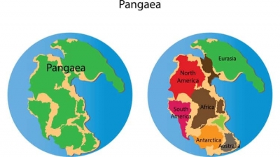
Pangaea

Wegener was convinced that all of Earth’s continents were once part of an enormous, single landmass called Pangaea.

Wegener, trained as an astronomer, used biology, botany, and geology describe Pangaea and continental drift. For example, fossils of the ancient reptile mesosaurus are only found in southern Africa and South America. Mesosaurus, a freshwater reptile only one meter (3.3 feet) long, could not have swum the Atlantic Ocean. The presence of mesosaurus suggests a single habitat with many lakes and rivers.

Wegener also studied plant fossils from the frigid Arctic archipelago of Svalbard, Norway. These plants were not the hardy specimens adapted to survive in the Arctic climate. These fossils were of tropical plants, which are adapted to a much warmer, more humid environment. The presence of these fossils suggests Svalbard once had a tropical climate.

Finally, Wegener studied the stratigraphy of different rocks and mountain ranges. The east coast of South America and the west coast of Africa seem to fit together like pieces of a jigsaw puzzle, and Wegener discovered their rock layers “fit” just as clearly. South America and Africa were not the only continents with similar geology. Wegener discovered that the Appalachian Mountains of the eastern United States, for instance, were geologically related to the Caledonian Mountains of Scotland.

Pangaea existed about 240 million years ago. By about 200 million years ago, this supercontinent began breaking up. Over millions of years, Pangaea separated into pieces that moved away from one another. These pieces slowly assumed their positions as the continent we recognize today.

Credit: National Geographic Society

Picture credit: Dreamstime.com

WHAT IS SIGNIFICANT ABOUT THE CENOZOIC ERA?

Life on our planet developed millions of years ago, but if large life-forms are taken into consideration, then intelligent organisms like the Homo sapiens have never dominated any specific era or even a period. The Cenozoic Era can be known as the arrival and dominance of intelligent life-forms like modern human beings, which changed the world scenario permanently.

The term 'Cenozoic' has been derived from the Greek words: kainos meaning 'new' and zoe meaning 'life'. It is the shortest era of the Earth, spanning from about 66 million years ago to the present. After the sudden K-T boundary mass extinction, mammals got a chance to evolve extensively in this era, and hence, it is also called 'The Age of The Mammals'. The climate of our planet stabilized and atmospheric oxygen slowly increases with a simultaneous decrease in carbon dioxide and other toxic gaseous elements.

Earlier, the Cenozoic comprised two periods: Tertiary and Quaternary, the former being divided into Paleogene and Neogene, but now the term Tertiary is slowly phased out. Instead, the era is now divided into three periods: Paleogene, Neogene, and Quaternary, ranging from the oldest to the youngest. They are again subdivided into a number of stages/epochs. Apart from mammals, the Aves class of Chordates, i.e., the birds also evolved a lot, and several of them were larger than the average height of a human.

Credit: science.earthjay.com

Picture Credit : Google