HOW DID GOLD GET HERE ON EARTH?

Have you ever wondered where precious metals like gold come from? Or how they became embedded in the deep crevices of our planet?

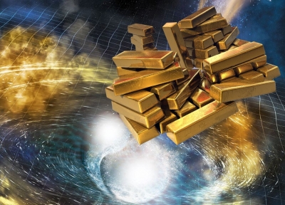
A gift from the stars

Gold is extraterrestrial. This means instead of arising from our planet's rocky terrain, this metal was actually created in space. Its presence on the Earth is a consequence of the cataclysmic explosions called supernovae. This powerful and luminous explosion occurs towards the end of a star's life.

Supernova

Matter is made up of atoms. These atoms consist of subatomic particles like protons (positively charged particles), electrons (which have a negative charge) and neutrons (neutral particles that form the centre of an atom). The region of an atom that accommodates neutrons is called a nucleus.

When two or more atoms' nuclei (plural of nucleus) merge to form a heavier atom, a large amount of energy is dissipated into the surrounding. This process is known as nuclear fusion.

Stars are mostly made up of hydrogen, which is the simplest and the lightest of all the elements. With time, the enormous gravitational pressure of so much material compresses and triggers nuclear fusion in a star's core.

The energy released due to this fusion is the reason why stars shine. Over millions of years, this fusion transforms hydrogen into heavier elements like helium, carbon, and oxygen. These heavier elements burn faster and faster to make iron and nickel.

Towards the last phase of a stars life, this fusion is unable to release enough energy, and the pressure from the core forces the outer layers of the heavenly body to collapse into the centre. This sudden injection of energy results in the explosion of the star or a supernova.

The pressure of this explosion is so high that it forces various subatomic particles to fuse and form neutrons. These neutrons are then captured and combined by the residual heavy metals from the star. This leads to the formation of heavier elements like gold, silver, lead and even uranium. The formation of heavy metals in a supernova takes place within seconds.

The remnants of supernova

The expanding shock wave from the explosion propels the remnants through space. The supernova debris enriches the space clouds and condenses to form new planets and stars.

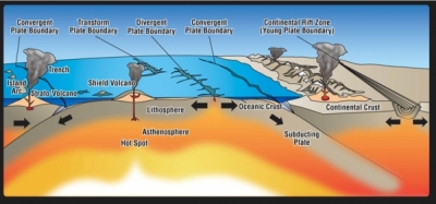
Researchers have found that Earth's reserve of gold is most likely a direct consequence of this phenomenon. This would mean that the cosmic cloud that condensed to form our planet had gold particles, which were then kneaded into the planet's crust due to the movement of the tectonic plates and other Geo-thermal activities.

Picture Credit : Google 

WHAT ARE THE FOUR FUNDAMENTAL FORCES OF NATURE?

The Four Fundamental Forces of Nature are Gravitational force, Weak Nuclear force, Electromagnetic force and Strong Nuclear force. The Four Fundamental Forces of Nature are Gravitational force, Weak Nuclear force, Electromagnetic force and Strong Nuclear force.

Gravitational Force

The gravitational force is weak but very long-ranged. Furthermore, it is always attractive. It acts between any two pieces of matter in the Universe since mass is its source.

Weak Nuclear Force

The weak force is responsible for radioactive decay and neutrino interactions. It has a very short range and. As its name indicates, it is very weak. The weak force causes Beta-decay ie. the conversion of a neutron into a proton, an electron and an antineutrino.

Electromagnetic Force

The electromagnetic force causes electric and magnetic effects such as the repulsion between like electrical charges or the interaction of bar magnets. It is long-ranged but much weaker than the strong force. It can be attractive or repulsive and acts only between pieces of matter carrying an electrical charge. Electricity, magnetism, and light are all produced by this force.

Strong Nuclear Force

The strong interaction is very strong but very short-ranged. It is responsible for holding the nuclei of atoms together. It is basically attractive but can be effectively repulsive in some circumstances. The strong force is ‘carried’ by particles called gluons; that is, when two particles interact through the strong force, they do so by exchanging gluons. Thus, the quarks inside of the protons and neutrons are bound together by the exchange of the strong nuclear force.

Note:  While they are close together the quarks experience little force, but as they separate the force between them grows rapidly, pulling them back together. To separate two quarks completely would require far more energy than any possible particle accelerator could provide.

Credit : Clearias

Picture Credit : Google 

HOW DO WE MEASURE CONTINENTAL DRIFT?

Satellite tracking stations were initially used to measure continental drift. At present, an accurate measurement can be done through GPS trackers. Radio telescopes also give an accurate reading.

Geologists in the early 1900's (and earlier) observed related fossil assemblages and rock groups on the margins of different continents separated by large oceans. Continental drift theory proposed that the continents were once contiguous. Measuring the distance across the ocean basins provided a distance of drift, but not a rate.

Scientists in the 1960's used magnetometers to survey the ocean floor (the magnetometers were retired sub-hunters from WWII). They observed parallel bands of seafloor with the same magnetic orientation and intensity. They noticed that the bands were symmetric on either side of large ridges in the oceans. Plate tectonics proposes that the continents are going along for the ride as oceanic crust grows and spreads from ridges. The scientists used radiometric dating to calibrate the magnetic bands with a magnetic reversal time scale.

We now have the distance that the continents are from each other, and ages for the bands of oceanic crust between them, so we can calculate a rate. For example, the oldest crust in the Atlantic is about 180 million years old, and it is found off the eastern margin of North America and the Western margin of Africa (~6000 km).

6000km/180 million years = ~3.3 cm/year (Averaged over 180 million years, this is a very rough calculation).

This is how fast Africa and North America have cruised apart on average over the last 180 million years.

Credit: UCSB Science Line

Picture Credit : Google

WHY DO THE CONTINENTS MOVE?

The surface of Earth is broken into giant fragments called tectonic plates. The continents are situated on top of these tectonic plates, which carry them much like cargo on rafts. The plates move at rates of between 2 and 17 cm per year, and over millions of years this moves the continents over many thousands of kilometres.

The earth’s crust is broken into separate pieces called tectonic plates. The crust is the solid, rocky, outer shell of the planet. It is composed of two distinctly different types of material: the less-dense continental crust and the more-dense oceanic crust. Both types of crust rest atop solid, upper mantle material. The upper mantle, in turn, floats on a denser layer of lower mantle that is much like thick molten tar.

Each tectonic plate is free-floating and can move independently. Earthquakes and volcanoes are the direct result of the movement of tectonic plates at fault lines. The term fault is used to describe the boundary between tectonic plates. Most of the earthquakes and volcanoes around the Pacific ocean basin—a pattern known as the “ring of fire”—are due to the movement of tectonic plates in this region. Other observable results of short-term plate movement include the gradual widening of the Great Rift lakes in eastern Africa and the rising of the Himalayan Mountain range. The motion of plates can be described in four general patterns:

  • Collision: when two continental plates are shoved together
  • Subduction: when one plate plunges beneath another
  • Spreading: when two plates are pushed apart
  • Transform faulting: when two plates slide past each other

Credit: EXPLORING OUR FLUID EARTH

Picture Credit : Google

WHICH FOSSIL CONNECTS ALL THE SOUTHERN CONTINENTS?

Fossil remains of the fern Glossopteris are found in Australia, Antarctica, India, Africa and South America.

Wegener found fossil evidence that the continents were once joined. The same type of plant and animal fossils are found on continents that are now widely separated. These organisms would not have been able to travel across the oceans. So how did the fossils get so far apart?

Fossils of the seed fern Glossopteris are found across all of the southern continents. These seeds are too heavy to be carried across the ocean by wind. Mesosaurus fossils are found in South America and South Africa. Mesosaurus could swim, but only in fresh water. Cynognathus and Lystrosaurus were reptiles that lived on land. Both of these animals were unable to swim at all. Their fossils have been found across South America, Africa, India, and Antarctica.

Wegener thought that all of these organisms must have lived side by side. The lands later moved apart so that the fossils are separated.

Credit: ck12

Picture Credit : Google

WHAT IS THE SAN ANDREAS FAULT IN CALIFORNIA, USA?

San Andreas Fault, major fracture of the Earth’s crust in extreme western North America. The fault trends northwestward for more than 800 miles (1,300 km) from the northern end of the Gulf of California through western California, U.S., passing seaward into the Pacific Ocean in the vicinity of San Francisco. Tectonic movement along the fault has been associated with occasional large earthquakes originating near the surface along its path, including a disastrous quake in San Francisco in 1906, a less serious event there in 1989, and a strong and destructive quake centred in the Los Angeles suburb of Northridge in 1994 that occurred along one of the San Andreas’s larger secondary faults.

According to the theory of plate tectonics, the San Andreas Fault represents the transform (strike-slip) boundary between two major plates of the Earth’s crust: the Northern Pacific to the south and west and the North American to the north and east. The Northern Pacific plate is sliding laterally past the North American plate in a northerly direction, and hence the San Andreas is classified as a strike-slip fault. The movement of the plates relative to each other has been about 1 cm (0.4 inch) per year over geologic time, though the annual rate of movement has been 4 to 6 cm (1.6 to 2.4 inches) per year since the early 20th century. Parts of the fault line moved as much as 6.4 metres (21 feet) during the 1906 earthquake.

Credit: Britannica

Picture Credit : Google

WHICH CONTINENTS COLLIDED TO FORM THE ALPS?

Continents collide, and the Alps begin to form

  • The North part of the African plate collides with the European plate and is thrust over the European plate. This is the start of the formation of the Alps which grows by 1000m per million years.
  • The Matterhorn is an interesting example of this collision:
  • The base of the Matterhorn contains rocks which were formed under the Tethys Sea. As the African plate moved into the Eurasian plate the denser oceanic crust was subducted under the lighter, continental crust.
  • The centre of the Matterhorn contains rocks from the Eurasian plate.
  • The top of the Matterhorn comprises of rocks from the African plate which was thrust up on top of the Eurasian plate when it collided together.

Credit: Alpen Wild

Picture Credit : Google

FROM WHERE IN THE SUPERCONTINENT DID ANTARCTICA BREAK AWAY?

Gondwana was an ancient supercontinent that broke up about 180 million years ago. The continent eventually split into landmasses we recognize today: Africa, South America, Australia, Antarctica, the Indian subcontinent and the Arabian Peninsula.

According to plate tectonic evidence, Gondwana was assembled by continental collisions in the Late Precambrian (about 1 billion to 542 million years ago). Gondwana then collided with North America, Europe, and Siberia to form the supercontinent of Pangea. The breakup of Gondwana occurred in stages. Some 180 million years ago, in the Jurassic Period, the western half of Gondwana (Africa and South America) separated from the eastern half (Madagascar, India, Australia, and Antarctica). The South Atlantic Ocean opened about 140 million years ago as Africa separated from South America. At about the same time, India, which was still attached to Madagascar, separated from Antarctica and Australia, opening the central Indian Ocean. During the Late Cretaceous Period, India broke away from Madagascar, and Australia slowly rifted away from Antarctica. India eventually collided with Eurasia some 50 million years ago, forming the Himalayan Mountains, while the northward-moving Australian plate had just begun its collision along the southern margin of Southeast Asia.

Credit: Britannica

Picture Credit : Google

WHAT IS CONTINENTAL DRIFT?

In the early 20th century, German scientist Alfred Wegener termed the movement over geological time of Earth’s major landmasses- Europe, the Americas, Africa, Australia, Asia and Antarctica- as ‘continental drift’. However, the modern day term is plate tectonics. Wegener suggested that landmasses may have pulled apart or pushed together to create new landforms. For example, he found evidence for this when he discovered fossils in Norway that indicated they originated in a tropical climate.

Continental drift describes one of the earliest ways geologists thought continents moved over time. Today, the theory of continental drift has been replaced by the science of plate tectonics.

The theory of continental drift is most associated with the scientist Alfred Wegener. In the early 20th century, Wegener published a paper explaining his theory that the continental landmasses were “drifting” across the Earth, sometimes plowing through oceans and into each other. He called this movement continental drift. 

Pangaea

Wegener was convinced that all of Earth’s continents were once part of an enormous, single landmass called Pangaea.

Wegener, trained as an astronomer, used biology, botany, and geology describe Pangaea and continental drift. For example, fossils of the ancient reptile mesosaurus are only found in southern Africa and South America. Mesosaurus, a freshwater reptile only one meter (3.3 feet) long, could not have swum the Atlantic Ocean. The presence of mesosaurus suggests a single habitat with many lakes and rivers.

Wegener also studied plant fossils from the frigid Arctic archipelago of Svalbard, Norway. These plants were not the hardy specimens adapted to survive in the Arctic climate. These fossils were of tropical plants, which are adapted to a much warmer, more humid environment. The presence of these fossils suggests Svalbard once had a tropical climate.

Finally, Wegener studied the stratigraphy of different rocks and mountain ranges. The east coast of South America and the west coast of Africa seem to fit together like pieces of a jigsaw puzzle, and Wegener discovered their rock layers “fit” just as clearly. South America and Africa were not the only continents with similar geology. Wegener discovered that the Appalachian Mountains of the eastern United States, for instance, were geologically related to the Caledonian Mountains of Scotland.

Pangaea existed about 240 million years ago. By about 200 million years ago, this supercontinent began breaking up. Over millions of years, Pangaea separated into pieces that moved away from one another. These pieces slowly assumed their positions as the continent we recognize today.

Credit: National Geographic Society

Picture credit: Dreamstime.com

WHAT IS SIGNIFICANT ABOUT THE CENOZOIC ERA?

Life on our planet developed millions of years ago, but if large life-forms are taken into consideration, then intelligent organisms like the Homo sapiens have never dominated any specific era or even a period. The Cenozoic Era can be known as the arrival and dominance of intelligent life-forms like modern human beings, which changed the world scenario permanently.

The term 'Cenozoic' has been derived from the Greek words: kainos meaning 'new' and zoe meaning 'life'. It is the shortest era of the Earth, spanning from about 66 million years ago to the present. After the sudden K-T boundary mass extinction, mammals got a chance to evolve extensively in this era, and hence, it is also called 'The Age of The Mammals'. The climate of our planet stabilized and atmospheric oxygen slowly increases with a simultaneous decrease in carbon dioxide and other toxic gaseous elements.

Earlier, the Cenozoic comprised two periods: Tertiary and Quaternary, the former being divided into Paleogene and Neogene, but now the term Tertiary is slowly phased out. Instead, the era is now divided into three periods: Paleogene, Neogene, and Quaternary, ranging from the oldest to the youngest. They are again subdivided into a number of stages/epochs. Apart from mammals, the Aves class of Chordates, i.e., the birds also evolved a lot, and several of them were larger than the average height of a human.

Credit: science.earthjay.com

Picture Credit : Google

WHICH IS THE OLDEST FISH FOSSIL?

Scientists have found the oldest face—and it's a fish.

The 419-million-year-old fish fossil could help explain when and how vertebrates, including humans, acquired our faces—suggesting a far more primitive origin for this critical feature of our success, a new study says.

"Entelognathus primordialis is one of the earliest, and certainly the most primitive, fossil fish that has the same jawbones as modern bony fishes and land vertebrates including ourselves," said study co-author Min Zhu of the Chinese Academy of Sciences in Beijing.

"The human jaw is quite directly connected to the jaw of this fish, and that's what makes it so interesting."

The bones comprising the fish's cheek and jaws appear essentially the same as those found in modern bony vertebrates, including humans, Zhu added. Because it boasts maxilla and mandible much like our own, the fish may be the earliest known creature with what we'd recognize as a face.

Credit: National Geographic

Picture Credit : Google

WHAT IS A COELACANTH?

THE COELACANTH (PRONOUNCED SEEL-uh-kanth) is an enormous, bottom-dwelling fish that is unlike other living fishes in a number of ways. They belong to an ancient lineage that has been around for more than 360 million years. Coelacanths can reach more than six feet long and weigh about 200 pounds, and they're covered in thick, scaly armor. It's estimated they can live up to 60 years or more.

There are two living species of coelacanth, and both are rare. The West Indian Ocean coelacanth (Latimeria chalumnae) lives off the east coast of Africa, while the Indonesian coelacanth (Latimeria menadoensis) is found in the waters off Sulawesi, Indonesia. They are the sole remaining representatives of a once widespread family of lobe-finned fishes; more than 120 species are known from the fossil record.

 Their jaws are hinged to open wide. Unique to any other living animal, the coelacanth has an intracranial joint, a hinge in its skull that allows it to open its mouth extremely wide to consume large prey.

They have tiny brains. A coelacanth's brain occupies only 1.5 percent of its cranial cavity. The rest of the braincase is filled with fat.

Credit: wired.com

Picture Credit : Google

WHEN DID THE FIRST MAMMAL APPEAR ON EARTH?

The first mammals were small and furred, and resembled rats or shrews. Megazostrodon was one of the earliest mammals. Though mammals appeared on Earth about 200 million years ago, they became common only after the extinction of dinosaurs.

Early mammals were inauspicious creatures. The first mammal-like forms appear in the fossil record during the late Triassic period, about 225 million years ago. They were small, superficially shrew-like forms, some no longer than a few centimeters. In the shadow of the dinosaurs — a group that coincidentally also made its first appearance in the late Triassic — the early mammals were certainly less than imposing. Throughout the Mesozoic period — for over 160 million years — the largest mammal was no bigger than a ground hog. Moreover, the many wondrous and sometimes bizarre mammals we know today — such as the whales, bats, elephants, and scaly pangolins — were not part of the Mesozoic and early Cenozoic scene.

Credit: Science Direct

Picture Credit : Google

HOW DOES FOOD PRODUCTION, TRANSPORTATION, AND CONSUMPTION AFFECT OUR PLANET ?


Humans must eat to live, but it shouldn't be at the cost of the environment. Our food production and consumption impact the planet in multiple ways and that's why changing the food system should become part of our climate mitigation initiatives, say scientists.

 Ensuring everyone in the world has access to a nutritious diet is one of the greatest challenges we face, but what's equally pertinent is to achieve this in a sustainable way. Food production, transportation, and consumption affect our planet in ways that we cannot ignore.

A new report from the Global Alliance for the Future of Food says that the world urgently needs to change the way it produces, distributes, consumes, and disposes of food to save the planet. The report says that we can reduce greenhouse gas emissions by at least 10.3 billion metric tons a year. That alone would get us 20% of the way to the Paris Climate Agreement's 2050 goals, it said. Food accounts for over a quarter (26%) of global greenhouse gas emissions. By the time the food you eat gets to your table, much of the environmental impact has already occurred. Here is a look at the ways our food production and consumption practices adversely affect our environment.

Land use and habitat loss

Did you know half of the world's habitable land is used for agriculture? In a bid to meet our growing food demand, more forest lands have been converted into farm lands. Destruction of forests leave animals and birds in them with no homes to go to and no food to eat. Habitat loss is one of the leading causes of population decline among wildlife species, eventually leading to extinction in many cases. According to data, of the 28.000 species evaluated to be threatened with extinction on the IUCN Red List, agriculture is listed as a threat for 24,000 of them. Deforestation also contributes to global warming and climate change, as forests are major carbon sinks that remove greenhouse gases from the atmosphere.

Use of chemicals for agriculture

Using fertilizers, herbicides, and pesticides impact the environment in two ways: 1) They affect even unintended organisms in the environment. For instance, exposure to neonicotinoid pesticides, which are used against sap-feeding insects such as aphids, has been shown to affect a bee's ability to navigate. Moreover, the toxic chemicals often end up on our plates. 2) The chemicals from fertilizers are released into the atmosphere, water bodies, and soil as harmful pollutants. These in turn affect all the organisms in a food chain. Pesticides have been shown to cause irreparable genetic damage, or even killing important populations. Agriculture runoffs in water bodies cause algal bloom, which in turn affects marine life.

Stress on water resources

Agricultural production has always been and is increasingly water-demanding. Irrigated agriculture is responsible for 70% of freshwater consumption globally. Rice, soybeans, wheat, and sugarcane are some of the water-intensive crops. Agriculture drains our water reserves at an incredible rate. Livestock animals also require large amounts of water. This puts pressure on already depleted water sources.

Greenhouse gas emissions

*Fossil fuels are used to fuel farm equipment such as tractors and graders. Their usage leads to air pollution. Livestock and fisheries account for 31% of food emissions. Livestock - animals raised for meat, dairy, eggs and seafood production - contribute to emissions in several ways. Cows produce methane gas as a result of digestion.

Supply chains account for 18% of food emissions. Food processing, converting produce from the farm into final products, packaging and retail all require energy and resource inputs. Transportation of food is another factor that influences the unsustainability of our food production systems. Where your food comes from also matters. Food that travels from countries far away from India will have a bigger carbon footprint than food grown locally. They use a tremendous amount of fossil fuels.

Food waste

Food is wasted throughout the entire production chain, from initial crop growth, to supermarket screening, to final household. consumption. Food waste includes food scraps, discarded food, and uneaten food. Food waste emissions are large: one-quarter of emissions from food system come from food waste. One third of food produced globally is wasted every year. Disposed of food makes the environment filthy. They end up in landfills, where it rots and produces methane, a greenhouse gas. Did you know 25% of the world's fresh water supply is used to grow food that is never eaten?

Picture Credit : Google 

DOES THE TEMPERATURE OF NEPTUNE CHANGE?

Neptune, the farthest planet in the solar system, takes more than 165 years to complete an orbit around the sun. As Neptune has an axial tilt, it experiences seasons, just like our Earth.

Sensing emitted heat : Neptune's great distance from the sun and the longer period of revolution, however, implies that its seasons change slowly, lasting over 40 Earth years each. A new research published in April in Planetary Science Journal revealed that the temperatures in Neptune's atmosphere have fluctuated unexpectedly over the last two decades, even though this period only represents half of a Neptune season.

An international team of researchers that included scientists from Leicester and NASA's Jet Propulsion Laboratory used observations that effectively sensed heat emitted from Neptune's atmosphere. They combined two decades worth of thermal infrared images of Neptune from the European Southern Observatory's Very Large Telescope; Gemini South telescope in Chile; Subaru Telescope, Keck Telescope, and the Gemini North Telescope in Hawaii; and spectra from NASA's Spitzer Space Telescope.

Cooler than we thought :  Analysing this data allowed the researchers to reveal a complete picture of trends in Neptune's temperatures like never before, and some of these revelations were unexpected, to say the least. Since the beginning of reliable thermal  imaging of Neptune in 2003, the datasets indicate a decline in Neptune's thermal brightness, which came as a surprise to the researchers. This means that the globally averaged temperature in Neptune's atmosphere has come down by almost 8 degrees Celsius from 2003 to 2018, making the planet cooler than what we thought  before.

 The data from Neptune's south pole, however, reveals a different dramatic change. Observations of this region show that Neptune's polar stratosphere has warmed up by nearly 11 degrees Celsius from 2018 to 2020, reversing the previous cooling trend.

As of now, the causes for these stratospheric temperature changes are unknown and follow-up observations of the temperature will be needed to further assess these findings. Some of those causes might be revealed by the James Webb Space Telescope that is set to observe both Uranus and Neptune later this year.

Picture Credit : Google