WHICH IS THE FIRST FULLY SOLAR-POWERED EDUCATIONAL INSTITUTE IN INDIA?

The Sri Aurobindo International Centre for Education in Puducherry is the first fully solar-powered educational institute in India. With solar panels installed on almost all the rooftops in the campus, the school produces three times more energy than what it consumes.  

Many schools encourage their students to switch off the fans and lights after use, plant trees and take other initiatives to save energy. However, very few go beyond just asking them to take precautions and save energy. SAICE is different. This educational institute is self-reliant in terms of energy; it meets all its energy requirements through solar power. Moreover, it produces three times the electricity it consumes and lights up many other buildings with the excess energy. And it has done so by devising and implementing a project almost entirely on its own.

SAICE is a part of the Sri Aurobindo Ashram in Pondicherry. It was in 2012 that Dr. Brahmanand Mohanty, an alumnus of SAICE, came up with the idea of making the ashram energy efficient with the help of a sustainable model.

Dr. Mohanty had a vision of developing a system that would make SAICE self-dependent for energy. With this in mind, he had a meeting with the trustees of the Ashram. They gave him the go ahead and even suggested that pilot research activities should be taken up with the active participation of the young teachers and students at the Institute. And then it all began. The whole project was conducted in two phases from 2012 to 2015.

Following this analysis, all inefficient lamps, fans, air conditioners, and computers, which had been in use since a long period of time, were substituted by more energy-efficient alternatives to lower the energy demand by more than 25 percent, without compromising on the quality and service.

With a better understanding of how much energy the educational institute was consuming, they came to the decision that a solar power plant should be installed inside the campus so as to meet all the energy demands in-house. Thus, a 17 kWp rooftop solar power plant was set up in the school by an Auroville-based solar installer.Teachers and students were involved in the entire process right from the start. They helped in the basic wiring, setting up the panels on the rooftop, and more.

Credit : The better india

Picture Credit : Google 

WHAT IS SO SPECIAL ABOUT SOCOTRA ISLAND?

Hosting hundreds of plant and animals species that are found nowhere in the world, it's small wonder that Yemen's Socotra archipelago has been called the Galapagos of the Indian Ocean.

Full of life!

Located more than 300 km from its parent country Yemen, the Socotra archipelago comprises four islands in the Indian Ocean between Somalia and Yemen. Covering a total area of nearly 4,000 sq.km., the islands are known for their rich biodiversity and unique flora and fauna. For instance, among the 825 plant species found in the region now, as many as 307 cannot be seen anywhere else in the world. Birds such as the Socotra starling, Socotra sunbird, and Socotra warbler are said to be found only here. A staggering 90% of reptile species and 95% of land snails too are said to be endemic (found nowhere else). Because of this, the place is often referred to as the "Galapagos of the Indian Ocean".

Lying close as it does to the African continent, the archipelago appears to be the extension of the Horn of Africa. About 20 million years ago, these islands were believed to have broken off the Gondwana supercontinent. The archipelago was declared a UNESCO World Heritage Site with "Outstanding Universal Value" in 2008. Though the habitats within the region appear to be healthy and safe, they are not without threat. These include tourism, invasive species, overusing of natural resources and natural disasters. In fact, the conservation outlook for this site has been assessed as "significant concern" in the latest assessment cycle 2020.

Wildlife

Nearly 200 species of birds, including land and sea, are said to be seen in the archipelago. Among them are garganeys, shovelers, pintails, teals, ducks, guinea fowls, quails, flamingoes, grebes, pigeons, doves, sandgrouses, coucals, nightjars, swifts, moorhens, stilts, plovers, stints, snipes, sandpipers, coursers, gulls, terns, tropicbirds, petrels, shearwaters, boobies, egrets, herons, ibises, ospreys, buzzards, owls, hoopoes, bee-eaters, falcons, shrikes, ravens, larks, martins, swallows, warblers, whitethroats, thrushes, wheatears, starlings, sunbirds, pipits, wagtails, buntings, and sparrows. As an archipelago, the region has a startling variety of corals, fishes, crabs, lobsters, and shrimps too, together adding up to more than 1,000 species!

Dragon's blood tree

Synonymous with the identity of Socotra, the dragon's blood tree is found nowhere else in the world. It "lives within remnants of prehistoric 'Dragonsblood forest on granite mountains and limestone plateaus" within Socotra.

Marked by a unique umbrella-shaped canopy, the tree is said to capture the moisture in the air through its leaves and take it to the roots. Having held an economically significant role for centuries, the tree has varied uses. When fed to cattle in very small quantities, the tree's berries are said to improve the animals' health.

The tree gets its name from the red-coloured resin it produces, and this resin is believed to have several medicinal uses. The International Union for Conservation of Nature's conservation status for the tree is "vulnerable".. Shockingly, it has been discovered that hardly any "populations are regenerating naturally". In addition, it has been noticed that "in some areas young trees lack the species' characteristic umbrella shape".

As climate change intensifies, "Socotra is drying out, with once reliable monsoon weather becoming patchy and irregular. And this could spell irreversible change to the archipelago and its unique inhabitants.

Picture Credit : Google 

WHAT IS SPECIAL ABOUT THE GEOGRAPHIC SOUTH POLE?

The geographic South Pole in Antarctica is the only place on earth where you can time travel! All lines of longitude converge at this exact point, so you are literally standing in all 24 time zones. You can step from today into yesterday and back into tomorrow! Since Antarctica is largely uninhabited, the continent is not officially divided into time zones. Research stations use the time zone of the country that operates them, while others observe the local time of countries nearby officially divided into time zones. Research stations use the time zone of the country that operates them, while others observe the local time of countries nearby.

What is a time zone?

A time zone can be described as a region of the Earth that observes a standard time for several purposes, including commercial, legal, and social. Time zones often follow the boundaries of a country and its subdivisions since it is convenient for places in close proximity to observe the same time. Time zones on land are usually offset from Coordinated Universal Time (UTC). The Earth’s rotation means that time zones are determined by the lines of longitude that connect the North and South Poles, and divide the globe into different time zones. A country or region may have multiple time zones. For example, the United States is spread across six time zones. However, since all lines of longitude converge at the poles, it means that the poles are technically located within all time zones simultaneously. 

Time at the geographic poles.

In most parts of the globe, lines of longitude determine the local time, such that the specific time is synchronized to the position of the Sun in the sky. However, this does not apply at the North and South Poles, where the rising and setting of the Sun occurs only once a year. At the North Pole, the sun is continuously above the horizon in the summer and below the horizon during winter. The Sun rises during the March equinox and reaches sunset around the September equinox. The South Pole does not receive any sunlight from March until September, while the Sun is continuously above the horizon from September until March, meaning that the pole experiences one of the coldest climates in the world.

How is time determined at the geographical poles?

While there are no permanent human settlements at the poles and no specific time zone has been assigned to either pole, explorers and polar expeditions choose to follow any time zone deemed convenient. Therefore, a group of explorers may choose to observe the same time zone as their country of origin or may opt to use Greenwich Mean Time. For example, a group working at the McMurdo Station in the South Pole followed the local time in New Zealand local time (UTC+12 or 13).

Credit : World atlas 

Picture Credit : Google 

WHICH IS THE LARGEST NATURAL FLOWER GARDEN IN THE WORLD?

The Dubai Miracle Garden, occupying over 780,000 sq feet, is the world's largest natural flower garden with over 150 million flowers and plants. The flowers are maintained with treated wastewater through a drip irrigation method, with an average of 757,082 litres of water used per day. The Dubai municipality re treats the grey water of the city and sends it directly to the Garden, where it is re-filtered and converted into high-quality water for watering. The Garden holds three Guinness World Records - world's largest vertical garden, world's biggest flower structure (Airbus A380 flower structure) and world's tallest topiary-supported sculpture (59 foot Mickey Mouse topiary). Other floral works of art include the Floating Lady, Floral Clock, Sunflower Field, Smurfs Village, Floral Castle, among others. It is also home to the Dubai Butterfly Garden, the world's largest and the region's first indoor butterfly garden and sanctuary for over 15,000 butterflies from 26 species.

The concept of the first miracle garden project was formed under an agreement between Dubailand and the Dubai Properties Group destination. The project development was done under an agreement with Akar Landscaping and Agriculture Company,led by Jordanian businessman Abdel Naser Rahhal. The cost of the project was estimated at AED 40 million (US$11 million).

The Dubai Miracle garden has achieved three Guinness World Records. In 2013, it was declared as the world's largest vertical garden. Currently an Airbus A380 flower structure in the garden is listed by Guinness World Records as the biggest flower structure in the world. The 18 metres (59 ft) topiary of Mickey Mouse, which weighs almost 35 tonnes, is the tallest topiary supported sculpture in the world.

Credit : Wikipedia 

Picture Credit : Google

WHY DEAD SEA CALLED DEAD SEA?

At the very lowest point on earth lies a natural wonder replete with a unique ecosystem, breathtaking desert views, and mineral treasures that have been attracting visitors for thousands of years: The Dead Sea. Located in the desert in southern Israel, it is also the world’s deepest hypersaline lake. Although the high salinity of the water makes it almost impossible to dive, in this article we will delve deep into its geological origins, geography and history, become familiar with the biology and chemistry of this unique environment and discover everything there is to do and where to stay in the area surrounding this natural gem. 

The Dead Sea is a salt lake located in the Judean desert of southern Israel, bordered by Jordan to the East. With its origin dating back to some four million years ago, it is one of earth’s saltiest bodies of water and is the lowest point on earth. Its arid desert climate features year-round sunny skies, relatively high temperatures, with little precipitation.

The Dead Sea is located at the lowest point on earth, which is thought to be the result of volcanic processes leading to a continuous dropping of land. It is one of the four saltiest bodies of water in the world. These special conditions are an outcome of its extreme geomorphological structure alongside a harsh desert climate. These create constant dramatic changes that form a landscape that is different from any other in the world. Also, the unique mineral content of the air, land, and water in the area is globally renowned for its therapeutic qualities, as is evident in that it has been a health resort for thousands of years.

There are contending theories about the Dead Sea formation. About 3.7 million years ago, the area now known as the Jordan River Valley was repeatedly flooded by water from the Mediterranean Sea. The waters created a lagoon called the Sedom Lagoon, which connected to the sea through what is currently called the Jezreel Valley. Later on, about 2 million years ago, the land between this lagoon and the Mediterranean Sea rose to such an extent, that the sea could no longer flood the area, leading to the creation of a landlocked lake. Shifts in tectonic plates led to the rising and dropping of the floor of the valley, and the harsh desert climate led to gradual evaporation and shrinking of the lake, until finally, about 70,000 years ago, what remained was the Dead Sea with its low elevation. 

Until the end of the 1960s, the Jordan River was the only major water source flowing into the Dead Sea, although there are small perennial springs under and around the lake, forming pools and quicksand pits along its edges. Today, after the diversion of the waters from the Sea of Galilee, the only incoming source of water is from sulfur springs and waste water, along with rare drizzles and flash floods.

Credit : Deadsea.com

Picture Credit : Google 

WHICH IS THE FIRST CARBON NEUTRAL VILLAGE IN INDIA?

Palli, a village in Jammu and Kashmir's border district of Samba, became India's first "carbon-neutral panchayat on April 24, 2022, with Prime Minister Narendra Modi dedicating to the nation a 500-kilowatt solar plant. Palli, according to the Prime Minister, has shown the way to the country by becoming carbon neutral. But what is carbon neutrality and how can it be achieved? Let's find out.

What is carbon neutrality?

We all know that carbon dioxide emissions are one of the primary causes of climate change and an increasingly warming planet. Carbon-neutrality is the state of achieving a balance between the greenhouse gases put out into the atmosphere and those removed. The term 'Net-zero' is sometimes used instead of carbon neutrality and they broadly mean the same. Increasingly, countries, companies, and organisations have been committing to achieve carbon-neutrality or net-zero carbon emission through measures such as reforestation and artificial carbon sequestering. But some environmental activists have criticised such offsetting measures as an excuse to continue polluting. If you've been wondering about the benefits of achieving carbon neutrality, there are many such as less pollution, improved air quality, better health and environment, green jobs, reducing the impact of climate change, and a greener planet.

How can it be achieved?

Carbon neutrality can be achieved by reducing the use of fossil fuels and by adopting renewable energy sources, by developing energy-efficient technologies, by adopting massive reforestation or tree-planting measures and by investing in technologies such as carbon sequestration that can remove carbon from the atmosphere. By the way, carbon sequestration is the process of capturing and storing atmospheric carbon dioxide underground permanently and safely. However, no technology or quantity of trees planted could offset the emissions currently generated globally, unless every country and every household is part of this solution.

Palli's feat

The unassuming village of Palli has made history by becoming India's first carbon-neutral solar village. It has achieved this feat with the installation of a 500-kilowatt solar plant. According to reports, the project was finished in record time (of nearly three weeks) at a cost of Rs. 2.75 crore. Under the central government's 'Gram Urja Swaraj' programme, as many as 1,500 solar panels put up on an area of 6,408 square metres will provide clean electricity to 340 homes in the model panchayat.

The green energy generated will be distributed to the village through the local power grid station, which has a daily requirement of 2,000 units.

Picture Credit : Google 

WHAT IS SPECIAL ABOUT CANADA'S MIGUASHA NATIONAL PARK?

Canada's Miguasha National Park is a treasure trove of natural history, as it holds within  it priceless fossils that educate us about what was in the world millions of years ago.

Spanning more than 215 acres, the Miguasha National Park is located on the southern coast of the Gaspe peninsula in Quebec, Canada. Unlike most parks around the world, this Park is not popular for its animals, plants, birds, reptiles, amphibians, insects, or marine creatures living today. However, it is an extremely important region to trace the history of the planet's wildlife as we know it, thanks to the fossils in this area.

On the shore of the peninsula are remarkably well-preserved fossil beds from the Devonian period (see box), from millions of years ago. From vertebrates and invertebrates (such as lobe-finned fishes) to plants, algae, and several microorganisms, the astonishing biodiversity of these fossils offers scientists much more than just a glimpse of Devonian life. Even though there are more than 50 Devonian period fossil sites across the globe, "none matches Miguasha in abundance of specimens, quality of fossil preservation and representation of evolutionary events for vertebrates".

Discovered in 1842, the site has been of great scientific interest and significance the world over, and fossil specimens from the location were sent to museums and universities for studies. In 1999, the Park was declared a UNESCO World Heritage Site, and is considered "the world's most outstanding illustration of the Devonian Period".

Past  forward

The most important contribution of the Miguasha National Park to the study of evolution is through the largest number of and best-preserved fossil specimens of the lobe-finned fish that gave rise to the first four-legged. air-breathing, terrestrial vertebrates the tetrapods

Among the fossils that made Miguasha popular are 21 species of fish fossils. And the most significant among them? The Eusthenopteron foordi- the extinct lobe-finned fish fossil. It is this creature's "limblike fins and two-way gills-and-lungs respiratory system that led to the present understanding of evolution from fish to four-limbed, land-dwelling vertebrates". And not surprisingly, this specimen has been named "the Prince of Miguasha"!

Good news but...

According to the International Union for Conservation of Nature, the conservation outlook for this site has been assessed as "good" in the latest assessment cycle (2020).

In fact rigorous and continuous fieldwork and research initiatives have resulted in the discovery of new fossils and resultant inferences on how Devonian fishes and tetrapods evolved over a period of time. Though fossil sites have the potential to be disturbed or damaged by human activity, this site is "secure and well protected". "Overall site management and protection can be rated as mostly or highly effective."

In addition to the research initiatives. the educational outreach programmes and "interpretive facilities for visitors" too have been impressive enough to create awareness.

Picture Credit : Google 

WHICH IS THE LARGEST MONOLITHIC STATUE IN THE WORLD?

The Great Sphinx at Giza is the world's largest monolithic statue. 

Egypt, the land of pharaohs and pyramids never fails to amaze its visitors with its rich culture, mysteries and monolithic pieces from the medieval times. One such mighty monument that has hundreds and thousands of spectators completely in awe is the Great Sphinx Of Giza, an imposing statue body of a lion and head of a human. Carved out of a single block of the surrounding limestone bedrock, this colossal Egyptian antiquity is claimed to be the oldest and the largest known sculpture in the world.

The prime reason to why the Sphinx was constructed is still unknown, but some historian buff and archaeological experts believe that the statues were sculpted to guard important areas. Likewise, the Great Sphinx Of Giza was constructed to guard the large three pyramids of Giza i.e., pyramids of Khufu (Cheops), Khafre (Chephren) and Menkaura (Mycerinus).

Archaeological also believe that this gigantic sphinx was once colorful with the face painted red and the body painted with blue and yellow color. They also claim that the Sphinx once has a long beard and a nose, which are now missing.

Built-in 2500 BC during the Fourth Dynasty of the Old Kingdom, the Great Sphinx Of Giza in Egypt sits on the Giza plateau right in front of the Great Pyramid of Giza. Facing east, this stunning monument shimmers with the rising sun each morning and the Great Sphinx of Giza height is 73 meters long and 20.21 meters. The Sphinx was submerged beneath the desert and the first documented attempt to clear the sand was undertaken in 1400 BCE with the pharaoh Tuthmosis IV.

After a series of the restoration process, the giant structure once again found itself buried under the sand up to its neck when Napoleon came to Egypt in 1798. Later, there were many excavation projects conducted to clear the sand from 1816 to 1858 by some of the well-known antiquarians including Giovanni Caviglia, Auguste Mariette, and Gaston Maspero, but were forced to abandon the process due the sand.

Picture Credit : Google 

WHICH VILLAGE IS KNOWN AS GREEN VILLAGE IN NAGALAND?

Khonoma in Nagaland is India's first "green village". The terrain of the village is hilly, ranging from gentle slopes to steep and rugged hillsides. The hills are covered with lush forestland, rich in various species of flora and fauna. The state bird, Blyth's tragopan, a pheasant now nationally endangered, is found here. Khonoma is a medium size village located in Sechü Zubza sub-division of Kohima district, Nagaland with total 424 families residing. The Khonoma village has population of 1943 of which 919 are males while 1024 are females as per Population Census 2011. The village is divided into three Thinuos, namely Merhüma (M-Khel), Semoma (S-Khel) and Thevoma (T-Khel).

Khonoma village has higher literacy rate compared to Nagaland. In 2011, literacy rate of Khonoma village was 83.41 % compared to 79.55 % of Nagaland. In Khonoma Male literacy stands at 93.72 % while female literacy rate was 74.19 %. As per constitution of India and Panchyati Raaj Act, Khonoma village is administrated by Sarpanch (Head of Village) who is elected representative of village.

In 1998 hunting was banned in Khonoma's forests after the killing of around 300 endangered Blyth's tragopan (Tragopan blythii) in a week as part of a hunting competition. Villagers were sensitized and educated, leading to the creation of the 20 sq km Khonoma Nature Conservation and Tragopan Sanctuary (KNCTS), the first-ever community-led conservation project in India. Hunters were recruited to serve as forest wardens with a good salary, an incentive to turn from hunting to conservation. Today, the sanctuary provides a safe haven for Blyth's tragopan, the state bird of Nagaland, and other vulnerable species such as the leopard, clouded leopard and Asiatic black bear. Conservation of Khonoma's natural resources combined with sustainable agricultural practices led to it earning its green title in 2005.

Credit : Wikipedia 

Picture Credit : Google 

WHERE DO THE MOST COLOURFUL BIRDS LIVE?

When we think of birds, we perhaps think of their resplendent colours. But did you know that not all birds are colourful? In fact, it was presumed for long that how colourful birds were depended a lot on the region they lived in. A recent study has confirmed this.

The research has shown that "tropical species of songbirds are indeed more colourful than their non-tropical counterparts". The study analysed over 4,500 species of songbirds (also known as the passerines) globally from the collection at the UK's Natural History Museum. Songbirds were chosen because "they represent around 60 per cent of all bird species". The study involved cutting-edge computer technology to analyse the colours and intensity in the plumage of birds. The "colourfulness score" thus obtained for birds across the globe revealed that it "is generally highest at the Equator and decreases with increasing latitude towards the poles". Birds in the tropics (regions of the Earth around the Equator), showed more colours than those living in other regions, north or south. Also, though in certain cases males and females look different, both are more colourful in the tropics than in other places. So, what exactly is causing this?

It is said that several factors, including climate, food, and the amount of light in their habitat, impact how colourful bird plumage is. The study showed that the most number of colourful species of birds were from rainforests and those that consumed fruits and floral nectar. "And there was also a positive association between colourfulness and the diversity of the bird communities." The variety and population of songbird species are higher in the regions closer to the Equator than others. So the study suggests that the colourfulness could be the result of evolution for identification-"this enhanced colourfulness may help them to distinguish themselves from all the other birds in their rich tropical communities".

Picture Credit : Google 

WHAT IS SPECIAL ABOUT BHUTAN?

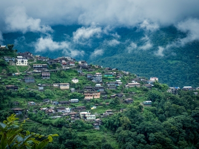
Nestled in-between the eastern ridges of the Himalayas in the central-south, Bhutan is a beautiful country and is also ranked as one of the happiest countries in the world, attracting tourists from far and wide to experience its tranquil and serene beauty. This beautiful Buddhist kingdom is renowned for its breathtaking landscapes and plains, magnificent mountains and steep valleys.

Bhutan is a small kingdom neighbouring India with a 786,500 population. It is also known as Druk yul or Druk Tsendhen, meaning "land of the thunder dragon", because of the frequent thunderbolts experienced here. However, it is a place of mountains and lakes, pilgrimages, artistic skills, adventure and tourism.

Bhutan does not believe in GDP as an indicator of economic growth and development, using instead a measurement known as Gross National Happiness. It has made this blessed kingdom a country of happy people on the global map. Bhutanese people have four pillars for the measure of GNH -sustainable development, preservation and promotion of cultural values, good governance and a healthy environment that makes it one of the happiest countries in the world.

People

There are three major ethnic groups in Bhutan: the Bhutia (also called Ngalop), the Nepalese and the Sharchop. The Bhutia is the largest ethnic group and they constitute about half of the population. The Bhutia are dominant in northern, central and western Bhutan. They speak a variety of Tibeto-Burman languages, and the most common of these, Dzongkha, is Bhutan's official language; the written language is identical with Tibetan. The Bhutias dominate Bhutan's political life. The Nepalese (including members of the Gurung ethnic group) predominate in the region and constitute roughly one-third of the country's total population. These are the most recent arrivals in Bhutan. Most speak Nepali.

About three-fourths of Bhutan's population follows Buddhism, primarily of the Tibetan variety. Besides Buddhism, Hinduism commands a significant following in Bhutan, particularly within the Nepalese community. Hindus constitute nearly one-fourth of the population. Proselytization is illegal in Bhutan.

Flora and Fauna

Bhutan's flora is notable for its great variety and its continuous transition from tropical through temperate to exclusively alpine forms. The moist zone of tropical deciduous vegetation occupies the south; in the Duars Plain and adjoining hills, tall dense grasses (used in the manufacture of paper and pulp) are an important plant resource in the lower elevations.

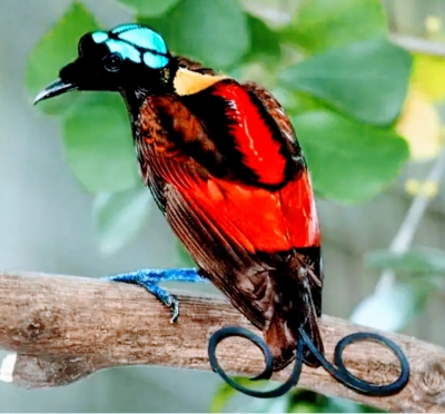
Sambar deer, gaurs (type of wild ox), rhinoceros, elephants, tigers and other animals are found in Bhutan, particularly along the Manas and Sankosh rivers in the central and eastern regions and in the country's forest-covered hills.

Art and Culture

Various art forms in Bhutan are inspired by the Buddhist religion. Poetry, dance, music, paintings and theatre in the country is deep rooted in the religion. Paintings include thangkas, wall paintings and sculptures. Masked dances are the main speciality, which are the re-enactment of Guru Rinpoche's life. Architecture is another feature which makes Bhutanese culture stand apart. In accordance with the country's geography and climate, traditional architecture, which includes sloped roofs, earthen walls and intricate wooden work, still thrives.

The festivals in Bhutan are an exciting time in the life of the Bhutanese, and an integral part of the unique culture of Bhutan. The most important Bhutanese festival is Tshechu. Every city has its own Tshechu, which lasts for 3-5 days. It falls on a particular day of a lunar month. It is generally held in a dzong, where people from the entire district and surrounding places gather together for the celebration. Monks and lay men wear silk robes and animal masks and re-enact events from Guru Rinpoche's life.

Bhutanese culture mandates that the traditional dress must be worn on special occasions and in government offices. Bhutanese men wear gho and women wear kira. Gho  is a heavy knee-length robe tied with a belt. Kira is an ankle-length dress over which a short jacket may be worn.

Traditionally food, cooked in earthenware, is eaten with hands while sitting cross-legged on the floor. Ema Datshi is the national dish of Bhutan. It is eaten throughout the country and in almost every meal. It usually consists of spicy chillies and cheese. Momos are yet another Bhutanese delicacy.

The music and dance forms of Bhutan, which are primarily inspired by religion, are part of every festival and celebration in the country. In annual events such as Tshechus, the king's birthday, etc., the whole country celebrates their legacy by dancing and singing.

Places of Interest

The Royal Manas National Park is the oldest in Bhutan and is spread across an area of 1,057 sq. km with numerous endangered wildlife species including the one horned rhino, Royal Bengal tiger, clouded leopard, Gangetic dolphin, Himalayan black bear, golden langur and many more.

Soi Yaktsa Trek: Trekking, undoubtedly, is one of the best adventure activities in Bhutan. The Soi Yaksa Trek has climbs that lead up to elevations as high as 4,700 m.

Pilgrim's Valley: It is one of the best Bhutan tourist spots covering the monasteries and dzongs from Paro to Bumthang.

Buddha Dordenma, Thimphu: It is the ultimate destination for photography with a giant golden Shakyamuni Buddha statue constructed to commemorate the anniversary of the fourth king of Bhutan, Jigme Singye Wangchuk.

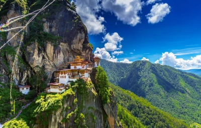
Taktsang Palphug Monastery, Paro: Popularly known as Tiger's Nest, it is one of the fascinating places for adventurers and pilgrims. The temple complex dates back to 1692.

Punakha Suspension Bridge, Punakha: The 160-metre long bridge spans the Po Chhu River, and connects Punakha Town with Punakha Dzong. It offers breathtaking views of the river flowing below and lush green hills all around it.

Interesting Facts about Bhutan

1. The ONLY carbon negative country in the world

Bhutan absorbs more carbon dioxide than it produces. Thanks to its lush forests which act as a carbon sink and absorb most of the carbon dioxide.

2. Isolated from the world until the 1970s

Bhutan was isolated entirely from the world until 1974 when the media was allowed to cover the new king's coronation, about 64 years since it was founded. Television sets came to Bhutan no sooner than 1990.

3. No smoking in public places

Smoking and usage of tobacco products are prohibited in public places like cinema halls, restaurants, streets, etc. Designated areas have been created for smokers, and anyone caught breaking the law face imprisonment for 3-5 years.

4. Birthday on New Year?

All citizens officially become a year older on New Year's Day. If people forget their birthday due to illiteracy or any other reason, it is easier to remember it by celebrating it on New Year's Day.

5. Bhutan has never been conquered

Bhutan has never been ruled by an external entity, thanks to its inaccessible territory and smart decisions and tactics by various kings and gurus who negotiated smart deals with the British when they were expanding their base in India and Nepal.

6. Education and healthcare is free for all citizens

The Government has taken necessary steps to ensure free health and educational facilities for all. The infant mortality rate is still a severe issue, but it has improved drastically. Most people still get their education from monasteries, and steps are being taken to increase the literacy rate.

7. The national sport is archery

The bow and arrow has played a significant role in many Bhutanese myths and legends. Bhutan maintains an Olympics archery team too.

8. Matriarchal family tradition

Women head the families and run all businesses from shops to farms. They even inherit property, and a man moves into his wife's house after marriage. Looks like feminism isn't much of an issue in Bhutan!

9. Bhutanese love their king!

The King of Bhutan is known for his humble personality and humanitarian efforts. Rightly called the "People's King", His Majesty Jigme Khesar Namgyel Wangchuck has met almost every citizen of his country and loves to talk to the people personally about their griefs and requirements.

10. It is mandatory to wear the national dress

It is mandatory to wear the national dress of Bhutan (gho for men and kira for women) to schools and government buildings on any formal occasion.

Bhutan has been a favoured destination for people around the world for its exquisite beauty, clean air, unique features and friendly administration. Tourists visiting Bhutan have always been awed by its unique culture and bountiful nature. Bhutan has led the banner for wellness travel for long, making their tourists' and their citizens' wellness a priority. Bhutan could be top priority on your wish list if you are planning to travel soon.

Picture Credit : Google 

Why is Roopkund called Skeleton Lake?

During World War II. an Indian forest Ranger called Hari Kishan Madhwa made a morbid discovery in a remote glacier lake in the Himalayas in Uttarakhand. Something strange was visible in its clear water. On closer inspection, it was revealed that the lake was full of human skeletons. It came to be known as Roop Kund or Skeleton Lake. A DNA sample of 38 skeletons showed that they came from three genetically distinct groups. Who were these people? When did they die? How did they die? Where did they come from?

One old theory associates the remains to an Indian king, his wife and their attendants, all of whom perished in a blizzard some 870 years ago.

Another suggests that some of the remains are of Indian soldiers who tried to invade Tibet in 1841, and were beaten back. More than 70 of them were then forced to find their way home over the Himalayas and died on the way.

Yet another assumes that this could have been a "cemetery" where victims of an epidemic were buried. In villages in the area, there's a popular folk song that talks about how Goddess Nanda Devi created a hail storm "as hard as iron" which killed people winding their way past the lake. India's second-highest mountain, Nanda Devi, is revered as a goddess.

Earlier studies of skeletons have found that most of the people who died were tall - "more than average stature". Most of them were middle-aged adults, aged between 35 and 40. There were no babies or children. Some of them were elderly women. All were of reasonably good health.

Also, it was generally assumed that the skeletons were of a single group of people who died all at once in a single catastrophic incident during the 9th Century.

Scientists genetically analysed and carbon-dated the remains of 38 bodies, including 15 women, found at the lake - some of them date back to around 1,200 years. They found that the dead were both genetically diverse and their deaths were separated in time by as much as 1,000 years.

But more interestingly, the genetics study found the dead comprised a diverse people: one group of people had genetics similar to present-day people who live in South Asia, while the other "closely related" to people living in present-day Europe, particularly those living in the Greek island of Crete. Also, the people who came from South Asia "do not appear to come from the same population".

Genetic studies found no evidence of the presence of any ancient bacterial pathogen that could provide disease as an explanation for the cause of deaths.

Credit : BBC 

Picture Credit : Google 

Where is Rani-ki-Vav also known as Queen's stepwell located?

Rani-ki-Vav is an underground stepwell located in Patan, Gujarat. Situated on the banks of the river Saraswati, this spectacular stepwell was built in the 11th century AD by Queen Udayamati of the Solanki dynasty in memory of her husband King Bhimdev 1.

A stepwell is a multi-tiered well with water that can be reached by descending a series of steps. Rani-ki-Vav has seven storeys of stairs and hundreds of intricately carved sculptures of Vishnu and other deities adoming its walls. It is over 65m long from the entrance to the well, 20m wide and 27m deep. It was declared a World Heritage Site by UNESCO in 2014. Did you know the site, before being unearthed by the Archaeological Survey of India in the 1980s, remained covered in mud and slush because of it being flooded by the river Saraswati for around 800 years?

Step wells of India have always mesmerized tourists from far and wide, for their unique architecture and carvings. Not only does Rani ki vav in Gujarat belong to this class of picturesque landmarks of India, it also has a special historical beginning to it. Read more to explore and quench your thirst about the ancient architecture of India. If you are travelling here for the first time, you might get confused as you won’t see a tall museum or the remains of a ruin because it is built inside an opening in the ground, which makes it special. The east facing well constructed in seven storeys is approximately 64m long, 20m wide & 27m deep. As you go down, you will see over 800 sculptures in the seven galleries, majority of which are devoted to lord Vishnu. It is amongst the finest step wells in India, and one of the most famous legacies of the ancient capital city. Various pillars and walls which are beautifully sculpted in Maru-Gurjara architectural style are a mesmerizing sight. The lowermost level of the well is blocked by stones and silt now but earlier it was used as an escape route to the neighbouring villages. It is one of the largest and the most sumptuous structures of its type. Rani-Ki-Vav is now considered to be the queen among the step wells of India. It is said that the size of the Rani Ki Vav is so huge that the tourists appear as ants climbing an anthill.

Picture Credit : Google 

Is Meghalaya the wettest place on Earth?

Mawsynram in Meghalaya is the wettest place, based on rainfall in the world. Located in the Khasi Hills, it receives about 11,872mm (nearly 467 inches) of average annual rainfall According to the Guinness Book of World Records, the region received 26,000mm of rainfall in 1985. The mountainous terrain of Mawsynram and the nearby Cherrapunji, the second wettest place, are known for their lush greenery and scenic beauty The "living bridges are one of the most beautiful features of this region. These have been created by the local people by training the roots of rubber trees into natural bridges. With the root systems constantly growing, these bridges are self-sustaining.

Primarily due to the high altitude, it seldom gets truly hot in Mawsynram. Average monthly temperatures range from around 11 °C in January to just above 20 °C in August. The village also experiences a brief but noticeably drier season from December until February, when monthly precipitation on average does not exceed 30 millimetres (1.2 in). The little precipitation during the village's "low sun" season is something that is shared by many areas with this type of climate.

Three reasons can be cited for high rainfall at Mawsynram:

The warm moist winds of the northward-moving air from the Bay of Bengal during the monsoon, which cover an extensive area but are forced to converge into the narrower zone over the Khasi Hills, thus concentrating their moisture.
The alignment of the Khasi Hills (east to west) places them directly in the path of the airflow from the Bay of Bengal, producing a significant uplift (plus cooling, further condensation and thus more rain).
Finally, uplift over the Khasi Hills is virtually continuous in the monsoon period because the lifted air is constantly being pulled up by vigorous winds in the upper atmosphere; hence, the rainfall is more or less continuous.

Credit : Wikipedia 

Picture Credit : Google 

What is so special about Lake Titicaca?

The biggest knitted objects in the world are the 62 self-fashioned Uros Islands in Peru's Lake Titicaca (the world's highest navigable lake at 12,500 feet above sea level).  The most remarkable thing about Lake Titicaca is its floating Islands and the people who live there. Each island is no more than 90 feet wide and is strong enough to hold several hundred people, buildings and boats (balsas). The Uru people collect totora reeds, which grow in the lake, and weave their dense roots together to form sturdy layers called 'khili' (about one to two metres thick). These are anchored with ropes attached to sticks driven into the bottom of the lake. The reeds at the bottom of the islands rot away fairly quickly, so new reeds are added to the top constantly, about every three months. If well maintained, an island can last for 30 years.

The houses and boats of the Uro people are built from the same reeds using a similar technique to that of the islands. They also make handcrafted items that they sell to visitors to the floating islands. About every six months they have to lift up and move their houses and buildings so that they can add another layer to the reeds of the floating island. When the Totora is pulled for construction, part of the root is eaten because it’s a rich source of iodine. It is also used for pain relief, tea and to cure a hangover. Fishing and hunting for birds is one of the main ways of getting food on the islands. The Uros also eat the guinea pigs and ducks that they keep on the islands. Waterbirds are also kept on the island but for helping them fish or for their eggs. On the islands, there is a traditional school and a Christian school that are the main sources of education on the islands. As the kids get older and start looking for university they will likely leave the lake and head to the mainland to study in Puno.

The Uro’s way of living is one to marvel at but is also extremely difficult and steadily disappearing. Many still live in the traditional way, hauling reeds into their boats, reconstructing the islands, heading off onto the lake to fish, but many of the young people are leaving and start a different life on the mainland. Daily life here depends mostly around the reeds that grow in the lake, they provide food, housing and transportation.  It is a life of hard work and long days in a harsh climate.

In recent years, tourism has become an important part of the Uro economy. People have opened their homes and welcomed visitors from all over the world. Their unique lifestyle and breathtaking Lake Titicaca make the floating islands a must when passing Puno.

Picture Credit : Google