HOW DO GLACIERS SHAPE LAND?

The sheer weight and size of glaciers give them an enormous power to carve out the landscape. Much like mega bulldozers, they crush and grind everything that comes in their way, pushing the debris along until it is deposited in distinctive piles called moraine.

Glaciers are huge masses of ice that move across the land. ?Glaciers? are often called rivers of ice for the way they move down mountainsides and carve valleys. Though climate change is threatening glaciers today, there are still many glaciers changing landscapes around the world through erosion and material deposition. Glacial landforms left behind by glaciers include moraines, drumlins, troughs, aretes, horns and cirques.

There are three distinct ways that glaciers shape the land: 1) erosion 2) transportation and 3) deposition. Erosion picks up material through weathering through plucking and abrasion. That material is then transported as it moves downhill. Sometimes the material is hidden inside or at the base of the glacier, or sometimes it is on top of the glacier, accounting for the dirty color of some glaciers. Those rocks and other transported materials eventually get deposited to a new place as the glacier melts; this leftover material is called glacial till, and it's what forms many of our landscapes today from the last ice age!

Credit: labroots

Picture credit: Google

WHAT IS AN ALPINE GLACIER?

When they form in the high mountains, these rivers of ice are called alpine glaciers. They flow down through the mountains, cutting and breaking up the rocks, creating sharp peaks, ridges and gouging out unique, U-shaped valleys.

A glacier that is surrounded by mountains is called an alpine or mountain glacier. They are a persistent body of snow that moves under its weight at a slow pace. Alpine glaciers are a sheet of snow that forms over a cirque or high rock basin. The iceberg’s uppermost layer is brittle, but the ice beneath behaves like a plastic substance flowing gently.

The glacier usually forms in a cirque or high rock basin where snow accumulates throughout the year. The most amazing fact about this glacier is that the rate of accumulation at the upper surface balances the rate of evaporation and melting at the lower end.

The glacier begins to occupy a sloping valley situated in between the creeks or steep rock walls. Following that, the accumulation of snow occurs at the upper part of the bowl-shaped depression called a cirque.

The glacial ice starts flowing downwards, slowly abrading and plucking the bedrock. The accumulation of snow that is compacting and recrystallizing is called firn.

The flow then accelerates across the steep rock where the deep crevasses or gaping fractures mark the icefall. The lower part of the glacier denotes ablation. As the ice thins, it evaporates and melts, thereby losing its plasticity. There are chances of developing fissures, as the glacier tries depositing debris at the terminus when it melts.

Credit: EARTHECLIPSE

Picture Credit : Google 

WHY ARE GLACIERS IMPORTANT?

Glaciers are a very important source of fresh water. Melting glacier ice keeps many of Earth's rivers flowing. Glaciers create fertile valleys for farming and their deposits are also rich in resources.

Glaciers are keystones of Life on Earth. As giant freshwater reservoirs, they support the planet’s life systems and influence our day-to-day lives, even for communities who live far away from them. However, glaciers are disappearing.

The disappearance of glaciers makes visible the invisible. It makes tangible the current climate change that can be hard to perceive in other ecosystems. The recent evolution of glaciers found in World Heritage sites paints a true picture of their decline in a warming planet.

A study led by Jean-Baptiste Bosson in 2019 shows that most World Heritage glaciers have lost a significant portion of their mass since 1900; some even completely disappeared, as in Africa or the Alps. The study predicts that glaciers could disappear from almost half of World Heritage sites by 2100 if business-as-usual emissions continue.

Credit: International Union for Conservation of Nature

Picture Credit : Google 

WHAT ARE FJORDS?

Fjords are very deep, long and narrow inlets with steep sides or sheer cliffs, seen along the coasts of Norway, New Zealand and Canada. A fjord is formed when the sea comes in to fill the U-shaped valley left by a glacier after it has retreated.

A fjord is a long, deep, narrow body of water that reaches far inland. Fjords are often set in a U-shaped valley with steep walls of rock on either side.

Fjords are found mainly in Norway, Chile, New Zealand, Canada, Greenland, and the U.S. state of Alaska. Sognefjorden, a fjord in Norway, is more than 160 kilometers (nearly 100 miles) long.

Fjords were created by glaciers. In the Earth's last ice age, glaciers covered just about everything. Glaciers move very slowly over time, and can greatly alter the landscape once they have moved through an area. This process is called glaciation.

Glaciation carves deep valleys. This is why fjords can be thousands of meters deep. Fjords are usually deepest farther inland, where the glacial force was strongest.

Some features of fjords include coral reefs and rocky islands called skerries.

Some of the largest coral reefs are found at the bottom of fjords in Norway. They are home to several types of fish, plankton and sea anemones. Some coral reefs are also found in New Zealand. Scientists know much less about these deep, cold-water reefs than they do about tropical coral reefs. But they have learned that the living things in cold-water reefs prefer total darkness. Organisms in cold-water reefs have also adapted to life under high pressure. At the bottom of a fjord, the water pressure can be hundreds or even thousands of kilograms per square meter. Few organisms can survive in this cold, dark habitat.

Skerries are also found around fjords. A skerry is a small, rocky island created through glaciation. Most of the Scandinavian coastline is cut into thousands of little blocks of land. These jagged bits of coastline are skerries. The U.S. states of Washington and Alaska also have skerries.

Even though skerries can be hard to get around in a boat, fjords are generally calm and protected. This makes them popular harbors for ships.

Credit:  National Geographic Society

Picture Credit : Google 

WHAT IS THE STUDY OF GLACIERS CALLED?

Glaciology is the study of natural forms of ice, particularly glaciers, and phenomena related to ice. It includes the study of how glaciers are formed and depleted, how they move, and how they affect the physical landscape, the climate, and living organisms. It is one of the key areas of polar research. It also involves research into glacial history and the reconstruction of past glaciation, thus providing insights into the ice ages. The apparent presence of ice on Mars and Jupiter's moon Europa brings in an extraterrestrial component to the field.

Thus, glaciology is an interdisciplinary earth science, integrating geophysics, geology, physical geography, geomorphology, climatology, meteorology, hydrology, biology, and ecology. The impact of glaciers on humans adds the fields of human geography and anthropology. A person who studies glaciers is called a glaciologist.

Credit: New World Encyclopedia

Picture Credit : Google 

WHY DO GLACIERS LOOK BLUE?

Glacial ice is a different color from regular ice. It is so blue because the dense ice of the glacier absorbs every other color of the spectrum except blue — so blue is what we see!

It’s Not Just Frozen Water!

Sometimes the glacial ice appears almost turquoise. Its crystalline structure strongly scatters blue light. The ice on a glacier has been there for a really long time and has been compacted down so that its structure is pretty different from the ice you normally see. Glacial ice is a lot different from the frozen water you get out of the freezer.

It’s Not Just Frozen Snow!

Glacial ice is not just frozen compacted snow. There are other things in the ice that make it much different from the ice in your home. Glaciers move through rock and soil as they carve their way down a slope. This means the ice is going to have a lot more ingredients than just water.

Credit: Alaska Satellite Facility

Picture Credit : Google 

WHAT ARE THE CRACKS IN GLACIERS CALLED?

Crevasse, fissure or crack in a glacier resulting from stress produced by movement. Crevasses range up to 20 m (65 feet) wide, 45 m (148 feet) deep, and several hundred metres long. Most are named according to their positions with respect to the long axis of the glacier. Thus, there are longitudinal crevasses, which develop in areas of compressive stress; transverse crevasses, which develop in areas of tensile stress and are generally curved downstream; marginal crevasses, which develop when the central area of the glacier moves considerably faster than the outer edges; and bergschrund crevasses, which form between the cirque and glacier head. At the terminus of the glacier many crevasses may intersect each other, forming jagged pinnacles of ice called seracs. Crevasses may be bridged by snow and become hidden, and they may close up when the glacier moves over an area with less gradient.

Credit: Britannica

Picture Credit : Google 

HOW DO GLACIERS FORM?

In places high above the snow line, where more snow gathers than melts, it gets tightly packed. New snow falls and buries the old snow, which turns more dense and grainy. This is called firn and the process is called firnification. Layers of firn build up on top of each other and as they get thick and heavy, the grains of firn merge into huge mases of ice. Over time, the tightly compacted ice becomes so heavy and exerts so much pressure that the glacier slowly starts to move and slide downhill.

Glaciers are huge masses of ice that cover the basement rock. They are found only in regions where snow cover is permanent, that is, at the poles and at high altitude.

At low temperatures, snow does not melt. It accumulates and is compacted into ice. This gradual metamorphosis, which can take several decades, results in the formation of an enormous mass of ice, several dozen meters thick--a glacier.

Propelled by its own weight, a mountain glacier may become detached from the rock wall and slide downward. It slowly flows into the valley like a river of ice. As it descends, the glacier picks up rocks and debris, which accumulate in the form of mounds, called moraines.

If the climate warms, the glacier melts. We say that it recedes. It leaves behind a profoundly eroded landscape composed of wide, flat bottom valleys and many lakes.

Credit: Britannica

Picture Credit : Google 

WHICH IS THE LARGEST GLACIER?

The world's largest glacier is the Lambert glacier in Antarctica, according to the United States Geological Survey. The glacier is more than 60 miles (96 km) wide at its widest point, about 270 miles (435) long, and has been measured to be 8,200 feet (2,500 meters) deep at its center.

Glaciers form when the annual snowfall in a region exceeds the rate at which the snow melts, allowing enormous amounts of snow to accumulate over time. The fallen snow compresses into solid ice under its own weight, forming solid sheets of ice.

And these sheets are in motion. Glaciers flow like very slow-moving rivers, and can stretch over hundreds of miles. The Lambert glacier flows at a rate of about 1,300 to 2,600 feet (400 to 800 meters) each year.

Credit: LIVE SCIENCE

Picture Credit : Google 

WHAT CAUSES TIDES?

Water level on the surface of the oceans rises and falls. These are called tides. Tides are a result of gravitational forces of the Moon and the Sun as well as the centrifugal forces of Earth's spin. The total amount of water does not change; it just rises at one place while receding at the other.

High tides and low tides are caused by the moon. The moon's gravitational pull generates something called the tidal force. The tidal force causes Earth—and its water—to bulge out on the side closest to the moon and the side farthest from the moon. These bulges of water are high tides.

As the Earth rotates, your region of Earth passes through both of these bulges each day. When you're in one of the bulges, you experience a high tide. When you're not in one of the bulges, you experience a low tide. This cycle of two high tides and two low tides occurs most days on most of the coastlines of the world.

Tides are really all about gravity, and when we're talking about the daily tides, it's the moon's gravity that's causing them.

As Earth rotates, the moon's gravity pulls on different parts of our planet. Even though the moon only has about 1/100th the mass of Earth, since it's so close to us, it has enough gravity to move things around.

When the moon's gravity pulls on the water in the oceans, however, someone's bound to notice. Water has a much easier time moving around, and the water wants to bulge in the direction of the moon. This is called the tidal force.

Because of the tidal force, the water on the side of the moon always wants to bulge out toward the moon. This bulge is what we call a high tide. As your part of the Earth rotates into this bulge of water, you might experience a high tide.

Credit: SciJinks

Picture Credit : Google 

WHAT ARE GLACIERS?

The word glacier comes from the French word glace, meaning ice. A glacier is a huge, slow-moving mass of ice. Glaciers are generally seen in mountainous regions where temperatures always remain close to freezing and a massive amount of ice accumulates. Forced by the weight of the ice and the pull of gravity, these sheets of ice start moving, almost like a river, although most glaciers move no more than one  centimetre a day.

Glaciers are massive bodies of slowly moving ice. Glaciers form on land, and they are made up of fallen snow that gets compressed into ice over many centuries. They move slowly downward from the pull of gravity.

Most of the world’s glaciers exist in the polar regions, in areas like Greenland, the Canadian Arctic, and Antarctica. Glaciers also can be found closer to the Equator in some mountain regions. The Andes Mountain range in South America contains some of the world’s largest tropical glaciers. About 2 percent of all the water on Earth is frozen in glaciers.

Glaciers can range in age from a couple hundred to thousands of years old. Most glaciers today are remnants of the massive ice sheets that covered Earth during the Ice Age. The Ice Age ended more than 10,000 years ago. During Earth’s history, there have been colder periods—when glaciers formed—and warmer periods—when glaciers melted.

Scientists who study glaciers are called glaciologists. Glaciologists began studying glaciers during the 19th century in order to look for clues about past ice ages. Today, glaciologists study glaciers for clues about global warming. Old photographs and paintings show that glaciers have melted away from mountain regions over time. Indeed, glaciers worldwide have been shrinking—and even disappearing—at an accelerated rate for the past several decades.

Credit: National Geographic Society

Picture Credit : Google 

WHAT IS THE DEEPEST POINT ON EARTH'S SURFACE?

It’s beneath the surface of the Pacific Ocean to the southeast of Japan. There, you’ll find a deep, crescent-shaped trench. This is called the “Mariana Trench.” Near the southern tip of the crescent, there is a small slot-shaped area. This is the deepest point on Earth—Challenger Deep.

The bottom of Challenger Deep is about 36,000 feet below sea level. That’s nearly seven miles! This makes it the deepest known place on Earth.

The Challenger Deep is named after a British Royal Navy ship called the HMS Challenger. It was the first ship to measure the depths of what is now known as the Challenger Deep. The Marianas Trench in the western Pacific is 11,030 m deep.  

The trench was measured by “sounding.” This involves dropping a very long line with a weight at the end into a body of water. Today, scientists and researchers use sonar to study ocean depths.

Only four descents into the Challenger Deep have ever been achieved. The first was in 1960 by a vessel called the Trieste. The Trieste was a special kind of ship called a “bathyscaphe,” invented by Jacques and Auguste Piccard. The name “bathyscaphe” is taken from the Greek words for “deep” and “ship.”

Credit: WONDEROPOLIS

Picture Credit : Google

WHAT IS THE AVERAGE DEPTH OF OCEANS?

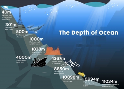
The average depth of the ocean is 3,700 meters (12,100 feet). But the deepest part ever recorded is located in the western part of the Pacific Ocean, in the Mariana Trench, at a depth of around 11,000 meters (36,200 feet).

Bathymetry is the scientific term for measuring the depth of water in oceans, lakes and rivers. Bathymetric maps are similar to land maps in that they show the different underwater landforms in a specific area. Scientists and researchers can use different methods to measure ocean depth.

The different methods are:

1. Sonar

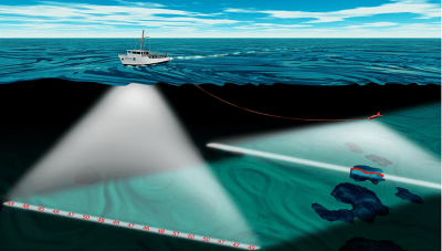
The most common and fastest way of measuring ocean depth uses sound. Ships using technology called sonar, which stands for sound navigation and ranging, can map the topography of the ocean floor. The device sends sound waves to the bottom of the ocean and measures how long it takes for an echo to return. The “echo” is the sound wave reflecting off the seabed and returning to the sonar device.

2. Radar and satellite

Another alternative, though not as fast as sonar, is radar. Similar to sonar, radar requires sending out a type of wave that pings off an object and reflects back. The difference is that radar uses radio waves, a form of electromagnetic wave. But because electromagnetic waves travel slower in water compared with air and become diminished as they travel through water, they are more ideal for atmospheric measurements.

Ocean Depth Measured in the Olden Days

Before the discovery of using sound and radar to measure ocean depth, captains and their crews used a different way to measure the depth of the ocean. Sailors would use a tool called a lead line, which was essentially a lead weight attached to a rope that is marked every 6 feet, a length called a fathom, with a rag or strip of leather. A crew member would then throw the line into the water, and once the lead weight reached the bottom the sailor would measure and record the distance to the ocean floor using the strips on the rope.

The lead line was the most valuable method of measuring depth for navigation and has been used since the fifth century BCE. The tool helped sailors know how deep the water was and if their ship would run aground. The bottom of the lead weight was cupped inward and filled with grease and was used to bring up samples from the ocean floor to help sailors determine if the ocean bed was sand, gravel or mud.

Credit: NIST

Picture Credit : Google

CAN THE DEEP OCEAN FLOOR BE MAPPED?

Ocean floors are mapped using sound equipment and robot submarines. Sonar systems send out high -frequency pulses. The time it takes for the sound pulse to echo back from the ocean floor gives an idea as to the depth of the ocean.

Understanding the depth and shape of the seafloor, called bathymetry, is not only a mapping challenge but it is important if we are to better understand are oceans. This includes understanding ocean circulation, which affects climate, tsunamis, environmental change, underwater geo-hazards, resources, and many other processes affecting the environment, safety, and commerce.

Mapping the seafloor has been occurring since the early 19th century; however, obtaining accurate data has been a challenge until the invention of the sonar. More recent sonars (short fo  Sound Navigation and Ranging) provide far more accurate data, particularly when multibeam echosounder sonars are used.

The Seabed 2030 project is a project attempting to map the seafloor by 2030. Until now, however, only about 20% of the seafloor has been mapped using modern bathymetry methods. In part, the project to map the seafloor will benefit from crowd sourced data obtained from various ocean-going vessels.

However, NOAA is also leading the effort and vessels with sonar equipment are being used to map regions not often travelled by vessels. These vessels are equipped with the latest multibeam sonars that provide hydrographic surveying results that can then build detailed maps with about 0.5 meter resolution.

The mapping efforts are attempting to use different frequencies, from around 12 kHz to closer to 200 kHz, often used in shallower waters. While generally deeper sea levels are easier to map, as sound waves travel and allow a wider region to be surveyed as a ship passes by, shallow areas present challenges, given that multiple passes need to cover less area and interference observed from other sea life and vessels can disrupt data.

Credit: GIS LOUNGE

Picture Credit : Google

WHICH IS THE BIGGEST OCEAN?

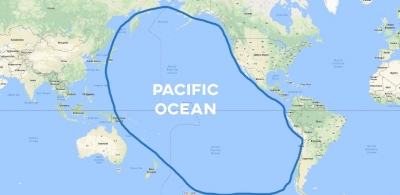
The Pacific is the biggest and the deepest Ocean. It covers a third of Earth's surface and has an area of 180 million km, holding more than 700 million km of water. It is so big that all the continents could fit within its area.

The Pacific Ocean is the largest ocean in the world, making up around 28% of the world’s surface area and almost double that in water surface area. It touches the west coast of North America. It is also home to the deepest trench on earth, the Marianas Trench, where the Challenger Deep is located. It’s 36,037 feet deep, far deeper than Mount Everest is tall. The trench is located between two tectonic plates, accounting for its incredible depth. The ocean’s coast line, along North America and Japan, is prone to earthquakes.

The ocean was named by the explorer Ferdinand Magellan. He chose “pacific” to mean “peaceful sea.” The Pacific Ocean is home to the Ring of Fire, a chain of 450 volcanoes in a u-shape. They reach from South America, along the coast of Japan, the western United States, all the way down into New Zealand. The Pacific Ocean is the world’s largest body of water.

Credit: OCEAN INFO

Picture Credit : Google