What’s space weather?
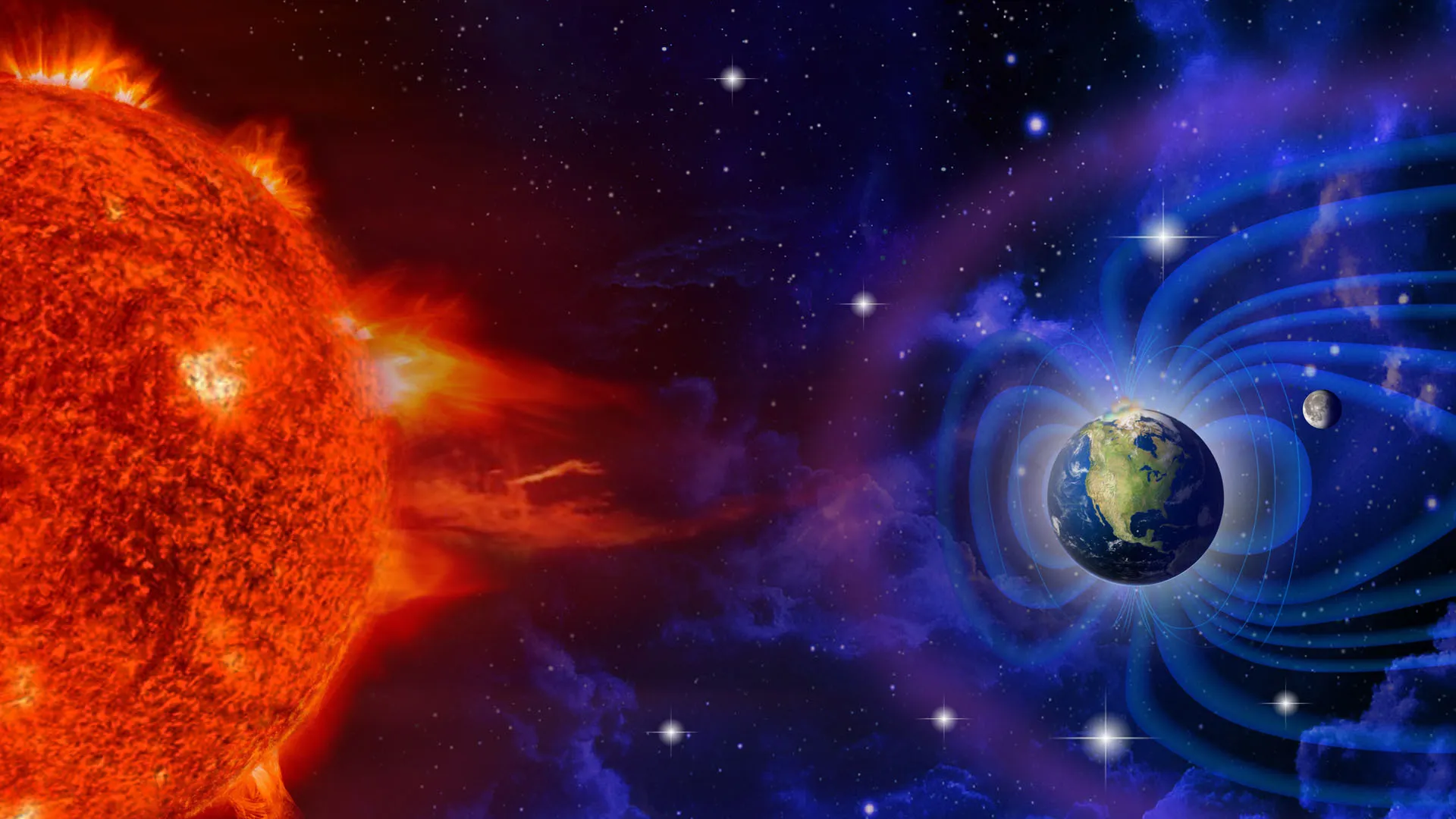
Ever wondered about the weather in space? Before that, let's think about what dictates the weather on our planet. The Sun, which is our source of energy, plays a titular role in governing the weather on Earth. And so does it create the weather in space! The activities on the Sun's surface can lead to a type of weather in space and this is called space weather.

Space weather is dependent on activities and changes on the Sun's surface such as coronal mass ejections (eruptions of plasma and magnetic field structures) and solar flares (sudden bursts of radiation). We are shielded from these bursts of radiation and energy by Earth's magnetosphere, ionosphere, and atmosphere.

Impact of space weather

The Sun is some 93 million miles away from our Earth. Yet, space weather can affect us and the solar system. The electric power distribution grids, global satellite communication, and navigation systems are all susceptible to conditions in space that are impacted by the Sun.

Space weather can damage satellites, affect astronauts and even cause blackouts on Earth. Such incidents are rare but they have happened before.

CME, solar flare

When a CME reaches Earth, it leads to a geomagnetic storm. This can disrupt services, damage power grids and cause blackouts.

For instance, back in 1989, a powerful geomagnetic storm led to a major power blackout in Canada. As a result, around 6 million people were left in the dark for about 9 hours.

Solar flares can also result in disruption of services. The strongest and most intense geomagnetic storm ever recorded occurred in 1859. This was caused by a solar flare. Called the "Carrington Event and named after England's solar astronomer Richard Carrington who observed the activity through his telescope, the geomagnetic storm caused damage, disrupting the telegraph system on Earth. It also led to the aurorae, a result of geomagnetic activity, being visible in regions such as Cuba and Hawaii.

While telegraph networks are a thing of the past, our communications system and technologies can still be impacted by space weather. Even as most of the charged particles released by the Sun get shielded away due to Earth's magnetic field, sometimes space weather can affect us. We need to track the activities on the Sun's surface and understand them to protect the people and systems.

Any warning regarding bad space weather can help scientists send alerts and lessen the damage caused by it. Space agencies have observatories monitoring the Sun and detecting solar storms. These help in mitigating the effect of bad space weather.

Picture Credit :Google
WHAT IS A MONSOON SEASON?

A monsoon is a seasonal wind pattern that lasts for several months and results in heavy rainfall during the summer and dry spells in the winter. It is responsible for the wet and dry seasons throughout much of the tropics. Typically Indian monsoon lasts from June-September, with large areas of western and central India receiving more than 90% of their total annual precipitation during the period. The word comes from the Arabic 'mausin' which means season and was first used in the English language during the British occupation of India.

What causes a monsoon?

A monsoon (from the Arabic mawsim, which means "season") arises due to a difference in temperatures between a land mass and the adjacent ocean, according to the National Weather Service. The sun warms the land and ocean differently, according to Southwest Climate Change, causing the winds to play "tug of war" eventually switching directions bringing the cooler, moister air from over the ocean. The winds reverse again at the end of the monsoon season. 

Wet versus dry

A wet monsoon typically occurs during the summer months (about April through September) bringing heavy rains, according to National Geographic. On average, approximately 75 percent of India's annual rainfall and about 50 percent of the North American monsoon region (according to a 2004 NOAA study) comes during the summer monsoon season. The wet monsoon begins when winds bringing cooler, more humid air from above the oceans to the land, as described above.

A dry monsoon typically occurs between October and April. Instead of coming from the oceans, the winds tend to come from drier, warmer climates such as from Mongolia and northwestern China down into India, according to National Geographic. Dry monsoons tend to be less powerful than their summer counterparts. Edward Guinan, an astronomy and meteorology professor at Villanova University, states that the winter monsoon occurs when "the land cools off faster than the water and a high pressure develops over the land, blocking any ocean air from penetrating." This leads to a dry period. 

The winds and rains

The monsoon season varies in strength each year bringing periods of lighter rains and heavier rains as well as slower wind speeds and higher wind speeds. The Indian Institute of Tropical Meteorology has compiled data showing yearly rainfalls across India for the last 145 years. 

According to the data, the intensity of a monsoon varies over an average of period of 30 – 40 years. In each period, the amount of rain received is higher than average resulting in many floods or lower than average resulting in droughts. The long-term data suggest that the monsoon trends may turn from being in a low rain period that began in approximately 1970 to a higher rain period. Current records for 2016 indicate that total rainfall between June 1 and September 30 is 97.3 percent of the seasonal normal.

The most rain during a monsoon season, according to Guinan, was in Cherrapunji, in the state of Meghalaya in India between 1860 and 1861 when the region received 26,470 millimeters (1,047 inches) of rain. The area with the highest average annual total (which was observed over a ten year period) is Mawsynram, also in Meghalaya, with an average of 11,872 millimeters (467.4 inches) of rain.

The average wind speeds in Meghalaya during peak summer monsoon season average 4 kilometers per second and typically vary between 1 and 7 kilometers per hour, according to Meteoblue. During the winter months, wind speeds typically vary between 2 and 8 kilometers per hour with an average of 4 - 5 kilometers per hour.

Credit : Live science 

Picture Credit : Google 

WHAT IS LA NINA WEATHER?

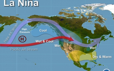
La Nina is a climatic pattern that refers to the cooling of the ocean surfaces along the tropical west coast of South America. During this weather pattern, warm ocean water and clouds move westwards increasing the chances of places like Indonesia and Australia getting much more rain than usual. These fluctuations tend to leave the regions of southwestern U.S. extremely dry.

The most severe La Nina occurrence in recent history was the 1988-89 event, which led to a seven-year drought in California. La Niña is a complex weather pattern that occurs every few years, as a result of variations in ocean temperatures in the equatorial band of the Pacific Ocean, The phenomenon occurs as strong winds blow warm water at the ocean's surface away from South America, across the Pacific Ocean towards Indonesia. As this warm water moves west, cold water from the deep sea rises to the surface near South America; it is considered to be the cold phase of the broader El Niño–Southern Oscillation (ENSO) weather phenomenon, as well as the opposite of El Niño weather pattern. The movement of so much heat across a quarter of the planet, and particularly in the form of temperature at the ocean surface, can have a significant effect on weather across the entire planet.

Tropical instability waves visible on sea surface temperature maps, showing a tongue of colder water, are often present during neutral or La Niña conditions.

La Niña events have occurred for hundreds of years, and occurred on a regular basis during the early parts of both the 17th and 19th centuries. Since the start of the 20th century, La Niña events have occurred during the following years:

1903–04
1906–07
1909–11
1916–18
1924–25
1928–30
1938–39
1942–43
1949–51
1954–57
1964–65
1970–72
1973–76
1983–85
1988–89
1995–96
1998–2001
2005–06
2007–08
2008–09
2010–12
2016
2017–18
2020–22

Credit :  Wikipedia 

Picture redit : Google 

WHAT IS THE KYOTO PROTOCOL?

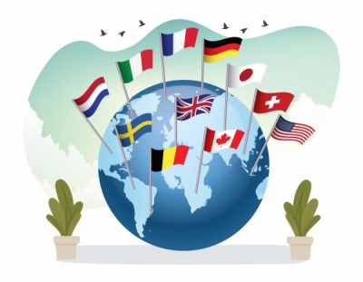
The Kyoto Protocol was the first significant international treaty that aimed to combat global warming. It was named after the city (in Japan) in which it was adopted in December 1997.

It urged participating countries to develop national programmes to reduce emission of greenhouse gases (like carbon dioxide and methane). It came into effect only in 2005 after delayed approval. Since 1997, 191 countries have backed the agreement. However, some developed countries including the US, Canada, and Russia have denied meeting the emission targets.

While the Kyoto Protocol expired in 2020, the Paris Agreement is now the active instrument to fight climate change.

The Kyoto Protocol is based on the principles and provisions of the Convention and follows its annex-based structure. It only binds developed countries, and places a heavier burden on them under the principle of “common but differentiated responsibility and respective capabilities”, because it recognizes that they are largely responsible for the current high levels of GHG emissions in the atmosphere.

In its Annex B, the Kyoto Protocol sets binding emission reduction targets for 37 industrialized countries and economies in transition and the European Union. Overall, these targets add up to an average 5 per cent emission reduction compared to 1990 levels over the five year period 2008–2012 (the first commitment period).

In Doha, Qatar, on 8 December 2012, the Doha Amendment to the Kyoto Protocol was adopted for a second commitment period, starting in 2013 and lasting until 2020.

As of 28 October 2020, 147 Parties deposited their instrument of acceptance, therefore the threshold of 144 instruments of acceptance for entry into force of the Doha Amendment was achieved.  The amendment entered into force on 31 December 2020.

The amendment includes:

New commitments for Annex I Parties to the Kyoto Protocol who agreed to take on commitments in a second commitment period from 1 January 2013 to 31 December 2020;
A revised list of GHG to be reported on by Parties in the second commitment period; and
Amendments to several articles of the Kyoto Protocol which specifically referenced issues pertaining to the first commitment period and which needed to be updated for the second commitment period.

Credit : United nations climate change 

Picture Credit : Google 

WHAT IS THE JET STREAM?

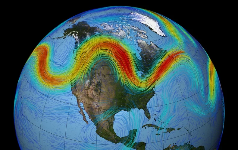
Jet streams are bands of strong wind that generally blow from the west to the east across the world. They impact weather, air travel and many other things that take place in our atmosphere. They form when warm air masses meet cold air masses in the atmosphere. The fast-moving air currents in a jet stream can impact the weather system in a region affecting temperature and precipitation. But if a weather system is far away from a jet stream, it might hover over one place, causing heat waves or floods.

What Causes Jet Streams?

Jet streams form when warm air masses meet cold air masses in the atmosphere.

The Sun doesn’t heat the whole Earth evenly. That’s why areas near the equator are hot and areas near the poles are cold.

So when Earth’s warmer air masses meet cooler air masses, the warmer air rises up higher in the atmosphere while cooler air sinks down to replace the warm air. This movement creates an air current, or wind. A jet stream is a type of air current that forms high in the atmosphere.

On average, jet streams move at about 110 miles per hour. But dramatic temperature differences between the warm and cool air masses can cause jet streams to move at much higher speeds — 250 miles per hour or faster. Speeds this high usually happen in polar jet streams in the winter time.

How Do Jet Streams Affect Air Travel?

Jet streams are located about five to nine miles above Earth’s surface in the mid to upper troposphere — the layer of Earth’s atmosphere where we live and breathe.

Airplanes also fly in the mid to upper troposphere. So, if an airplane flies in a powerful jet stream and they are traveling in the same direction, the airplane can get a boost. That’s why an airplane flying a route from west to east can generally make the trip faster than an airplane traveling the same route east to west.

How Do Jet Streams Affect Weather?

The fast-moving air currents in a jet stream can transport weather systems across the United States, affecting temperature and precipitation. However, if a weather system is far away from a jet stream, it might stay in one place, causing heat waves or floods.

Earth’s four primary jet streams only travel from west to east. Jet streams typically move storms and other weather systems from west to east. However, jet streams can move in different ways, creating bulges of winds to the north and south.

How Does the Jet Stream Help Us Predict the Weather?

Weather satellites, such as the Geostationary Operational Environmental Satellites-R Series (GOES-R), use infrared radiation to detect water vapor in the atmosphere. With this technology, meteorologists can detect the location of the jet streams.

Monitoring jet streams can help meteorologists determine where weather systems will move next. But jet streams are also a bit unpredictable. Their paths can change, taking storms in unexpected directions. So satellites like GOES-16 can give up-to-the-minute reports on where those jet streams are in the atmosphere — and where weather systems might be moving next.

Credit : Science jinks 

Picture Credit : Google 

WHAT IS ICEBERG CALVING

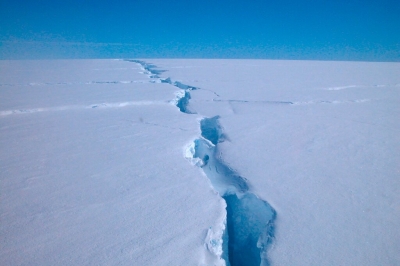
Iceberg calving, also called glacier calving, is the breaking away or release of huge ice chunks from the termini of glaciers or the margins of ice shelves. Ice shelves can calve huge tabular icebergs over decades or longer like the Antarctic’s Larsen C Sometimes, small fast flowing glaciers continuously calve small chunks of ice into their fjords like the San Rafael glacier in Chile.

Causes of iceberg calving

It is useful to classify causes of calving into first, second, and third order processes. First order processes are responsible for the overall rate of calving at the glacier scale. The first order cause of calving is longitudinal stretching, which controls the formation of crevasses. When crevasses penetrate the full thickness of the ice, calving will occur. Longitudinal stretching is controlled by friction at the base and edges of the glacier, glacier geometry and water pressure at the bed. These factors, therefore, exert the primary control on calving rate.

Second and third order calving processes can be considered to be superimposed on the first order process above, and control the occurrence of individual calving events, rather than the overall rate. Melting at the waterline is an important second order calving process as it undercuts the subaerial ice, leading to collapse. Other second order processes include tidal and seismic events, buoyant forces and melt water wedging.

When calving occurs due to waterline melting, only the subaerial part of the glacier will calve, leaving a submerged 'foot'. Thus, a third order process is defined, whereby upward buoyant forces cause this ice foot to break off and emerge at the surface. This process is extremely dangerous, as it has been known to occur, without warning, up to 300m from the glacier terminus.

Credit : Wikipedia 

Picture Credit : Google 

WHAT IS HEAT WAVE?

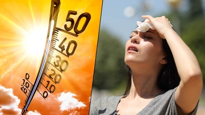
Heatwave is a period of abnormally high surface temperatures relative to what's actually expected over a region at a particular time of the year. Countries have adopted their own standards to declare a heatwave. Heatwaves occur in summer when the high pressure across an area moves slowly, thereby persisting over it for a few days or even weeks. Heatwaves have been observed globally since the 1950s, and have been associated with climate change. It can lead to heat-related stress such as dehydration, exhaustion and heatstroke.

Dangerous Heat

For some, a heat wave might sound like an excuse to run around with a hose or into some sprinklers. In reality, though, heat waves are no laughing matter. They are serious weather phenomena that can be quite dangerous.

How Do Heat Waves Form?

Heat waves are generally the result of trapped air. During the 2012 heat wave, air was trapped above much of North America for a long period of time. As opposed to cycling around the globe, it simply stayed put and warmed like the air inside an oven.

The culprit? A high-pressure system from Mexico. Between June 20th and June 23rd, this system migrated north. It grew in size, and it parked itself over the Great Plains of the United States.

High-pressure systems force air downward. This force prevents air near the ground from rising. The sinking air acts like a cap. It traps warm ground air in place. Without rising air, there was no rain, and nothing to prevent the hot air from getting hotter.

But that wasn’t all. A weather pattern that normally pulls air toward the east was also weaker at the time. That meant that there was little that could be done to push this high-pressure cap out of the way.

Credit : Sci jinks

Picture Credit : Google 

WHAT IS EL NINO WEATHER?

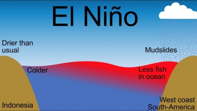
A climate pattern describing the unusual warming of surface waters in the easter tropical Pacific Ocean, El Nino corresponds to the warm phase of the larger phenomenon known as the El Nino-Southern Oscillation (ENSO). The pattern that describes the unusual cooling of the region's surface waters, or the cool phase of ENSO, is referred to as La Nina. Ocean temperatures, the speed and strength of ocean currents, health of local fisheries, and the local weather of regions from Australia to South America and beyond are affected by the El Nino, which is not a regular cycle.

The El Nino phenomenon caused muddy rivers to overflow along the entire Peruvian coast in 2017.

El Nino can be understood as a natural phenomenon wherein the ocean temperatures rise especially in parts of the Pacific ocean. It is the nomenclature which is referred to for a periodic development along the coast of Peru. This development is a temporary replacement of the cold current along the coast of Peru.   El Nino is a Spanish word. The term El Nino basically means ‘the child’. This is due to the fact that this current starts to flow around Christmas and hence the name referring to baby Christ.

Another natural phenomenon, similar to El Nino is La Nina, which is also in news these days. The term La Nina literally means ‘ little girl’. It is termed as opposite to the phenomenon of El Nino as it results in the ‘cooling’ of the ocean water in parts of the Pacific ocean.   Both of them also result in changes in atmospheric conditions along with oceanic changes.

El Nino Effects

El Nino results in the rise of sea surface temperatures
It also weakens the trade winds of the affected region
In India, Australia, it can bring about drought conditions. This affects the crop productivity largely. It has been also observed certain times, that EL Nino may not bring drought but cause heavy rainfall. In both the cases, it causes heavy damage.
However, in some other countries it may result in a complete reversal, i.e., excessive rainfall.

 Mitigation Of  Effects:

Keeping a check on the sea surface temperatures.
Maintaining sufficient buffer stocks of food grains and ensuring their smooth supply.
Ensuring relevant support to the farmer community including economic help.
Alternative ways to be promoted such as the practice of sustainable agriculture.

Credit : BYJUS.com

Picture Credit : Google 

WHAT IS WEATHERING CAUSED BY SALT CRYSTALS CALLED?

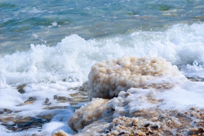
Haloclasty is a type of physical weathering caused by the growth of salt crystals. The process is first started when saline water seeps into cracks and evaporates depositing salt crystals. When the rocks are then heated, the crystals will expand putting pressure on the surrounding rock which will over time splinter the stone into fragments.

Salt crystallization may also take place when solutions decompose rocks (for example, limestone and chalk) to form salt solutions of sodium sulfate or sodium carbonate, from which water evaporates to form their respective salt crystals.

The salts which have proved most effective in disintegrating rocks are sodium sulfate, magnesium sulfate, and calcium chloride. Some of these salts can expand up to three times or more in volume.

It is normally associated with arid climates where strong heating causes strong evaporation and therefore salt crystallization. It is also common along coasts. An example of salt weathering can be seen in the honeycombed stones in sea walls.

Credit: Wikipedia

Picture Credit : Google 

WHAT KIND OF CONDITIONS SPEEDS UP WEATHERING?

The presence of water and changing temperature. Weathering happens less in very hot and dry areas, as well as places that are extremely cold and dry, where the temperature does not change much.

Weathering is a natural process, but human activities can speed it up.

 For example, certain kinds of air pollution increase the rate of weathering. Burning coal, natural gas, and petroleum releases chemicals such as nitrogen oxide and sulfur dioxide into the atmosphere. When these chemicals combine with sunlight and moisture, they change into acids. They then fall back to Earth as acid rain.

 Acid rain rapidly weathers limestone, marble, and other kinds of stone. The effects of acid rain can often be seen on gravestones, making names and other inscriptions impossible to read.

Credit: National Geographic Society

Picture Credit : Google 

WHAT IS WEATHERING?

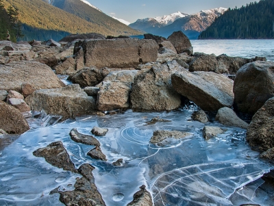
It is a process in which hard rock and minerals on the surface of Earth gradually break down and change form because they are exposed to wind, water, salt and varying temperatures. Weathering is the first step in the formation of soil. There are two types of weathering: mechanical and chemical. In the first type, rocks break up into smaller fragments, whereas in the second, the original material transforms into another substance.

Weathering, disintegration or alteration of rock in its natural or original position at or near the Earth’s surface through physical, chemical, and biological processes induced or modified by wind, water, and climate.

During the weathering process the translocation of disintegrated or altered material occurs within the immediate vicinity of the rock exposure, but the rock mass remains in situ. Weathering is distinguished from erosion by the fact that the latter usually includes the transportation of the disintegrated rock and soil away from the site of the degradation. A broader application of erosion, however, includes weathering as a component of the general denudation of all landforms along with wind action and fluvial, marine and glacial processes. The occurrence of weathering at or near the Earth’s surface also distinguishes it from the physical and chemical alteration of rock through metamorphism, which usually takes place deep in the crust at much higher temperatures.

Credit: Britannica

Picture Credit : Google 

WHAT ARE TORNADOES?

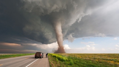
A tornado, also called a twister, is a violently rotating funnel of air, set off by giant thunderclouds called supercells. The vortex, known as a land spout, is a whirling mass of air hanging from the base of the cloud down to the ground, like the hose of a vacuum cleaner. Over water, a tornado forms a water spout. Tornadoes can also occur as two or more spinning vortexes spinning around each other.

Tornadoes are violently rotating columns of air, extending from a thunderstorm, which are in contact with the ground. Tornadoes develop when wind variations with height support rotation in the updraft. Tornadoes come in different sizes, many as narrow rope-like swirls, others as wide funnels.

Across the Plains, tornadoes can be seen from miles away. However, in the southeast, and especially Georgia, tornadoes are often hidden in large swaths of rain and hail, making them very difficult to see and even more dangerous. Visibility is often affected by terrain constraints in Georgia as well.

As stated before, tornadoes come in different shapes and sizes. They are ranked using the Enhanced Fujita scale. The majority of tornadoes which occur are classified as a weak tornado. Usually weak tornados will last for just a few minutes and have wind speeds of 100 mph or less. Some tornadoes intensify further and become strong or violent. Strong tornadoes last for twenty minutes or more and may have winds of up to 200 mph, while violent tornadoes can last for more than an hour with winds between 200 and 300 mph! These violent tornadoes are rare in occurrence.

Credit: NOAA

Picture Credit : Google 

WHAT IS A BLIZZARD?

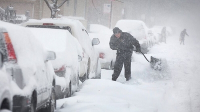
A prolonged winter storm that combines heavy snowfall, strong winds of more than 56 km per hour, and very low temperature, all resulting in very low visibility.

The United States National Weather Service’s winter weather advisory, watch, or warning system helps meteorologists determine whether atmospheric conditions should be classified as typical winter weather, a snowstorm, or a severe blizzard.

In order for meteorologists to classify a winter storm as a snowstorm, the air temperature high in the atmosphere and near the ground must be below 0°C (32°F). There also needs to be enough water vapor in the air to form snowflake crystals. While snowstorms do not typically last very long (less than a few hours), they can bring high snow accumulations, which can be hazardous.

For a snowstorm to be considered a blizzard, it must also meet specific, though more severe, conditions. To be categorized as a blizzard, the storm must last for at least three hours and produce a large amount of falling snow. Blizzards also have winds measuring over 56 kilometers (35 miles) per hour. These winds cause a large volume of snow to blow around in the air and near the ground, decreasing visibility. Meteorologists will declare blizzard conditions if the snow limits visibility to the point where it is difficult to see an object more than 0.4 kilometers (0.25 miles) away.

Credit: National Geographic Society

Picture Credit : Google 

WHEN WAS THE DEADLIEST HURRICANE EVER RECORDED?

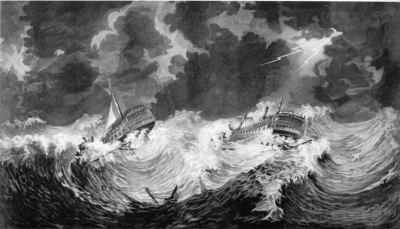
More than 20,000 people died in the Caribbean during the Great Hurricane of 1780, when winds may have reached a phenomenal 320 km per hour.

Great hurricane of 1780, hurricane (tropical cyclone) of October 1780, one of the deadliest on record in the Atlantic Ocean. More than 20,000 people were killed as the storm swept through the eastern Caribbean Sea, with the greatest loss of life centred on the Antilles islands of Barbados, Martinique, and Sint Eustatius.

The hurricane took place before modern tracking of tropical storms began, but historical accounts indicate that the storm started in the Atlantic and on October 10 reached Barbados, where it destroyed nearly all the homes on the island and left few trees standing. Witness reports in Barbados and Saint Lucia claimed that even sturdy stone buildings and forts were completely lost to the wind, with heavy cannons being carried hundreds of feet. The storm traveled northwest across the Antilles, causing destruction throughout the region; on some islands entire towns disappeared. The storm ravaged Martinique, taking an estimated 9,000 lives. On the island of Sint Eustatius an estimated 4,000 to 5,000 people were killed. During this time, European naval forces were concentrated in the Caribbean because of the American Revolution, and both British and French forces sustained particularly large losses, with more than 40 French vessels sunk near Martinique and roughly 4,000 soldiers dead. As the storm continued north, it damaged or sank many other ships that were returning to Europe.

Credit: Britannica

Picture Credit : Google 

What are Hurricanes?

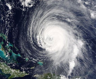
A hurricane is a giant, spiralling tropical storm in the Atlantic Ocean that can reach wind speeds of over 257 km per hour and unleash more than nine trillion litres of rain! It begins as thunderstorms that are set off by moist air rising over the warm ocean. If the water is warm enough, the thunderstorms join together, growing bigger as they begin to spiral across the ocean. As the hurricane grows, it spins faster and tighter around its centre, or 'eye', which remains a very calm area of low pressure. A hurricane can be as much as 800 km across and can take l8 hours to pass over. In the northern Indian Ocean hurricanes are known as cyclones and in the western Pacific Ocean, as typhoons.

Hurricanes are large, swirling storms. They produce winds of 119 kilometers per hour (74 mph) or higher. That's faster than a cheetah, the fastest animal on land. Winds from a hurricane can damage buildings and trees.

Hurricanes form over warm ocean waters. Sometimes they strike land. When a hurricane reaches land, it pushes a wall of ocean water ashore. This wall of water is called a storm surge. Heavy rain and storm surge from a hurricane can cause flooding.

Once a hurricane forms, weather forecasters predict its path. They also predict how strong it will get. This information helps people get ready for the storm.

There are five types, or categories, of hurricanes. The scale of categories is called the Saffir-Simpson Hurricane Scale. The categories are based on wind speed.

  • Category 1: Winds 119-153 km/hr (74-95 mph) - faster than a cheetah
  • Category 2: Winds 154-177 km/hr (96-110 mph) - as fast or faster than a baseball pitcher's fastball
  • Category 3: Winds 178-208 km/hr (111-129 mph) - similar, or close, to the serving speed of many professional tennis players
  • Category 4: Winds 209-251 km/hr (130-156 mph) - faster than the world's fastest rollercoaster
  • Category 5: Winds more than 252 km/hr (157 mph) - similar, or close, to the speed of some high-speed trains

Credit: NASA

Picture credit: NASA