WHAT IS THE STUDY OF GLACIERS CALLED?

Glaciology is the study of natural forms of ice, particularly glaciers, and phenomena related to ice. It includes the study of how glaciers are formed and depleted, how they move, and how they affect the physical landscape, the climate, and living organisms. It is one of the key areas of polar research. It also involves research into glacial history and the reconstruction of past glaciation, thus providing insights into the ice ages. The apparent presence of ice on Mars and Jupiter's moon Europa brings in an extraterrestrial component to the field.

Thus, glaciology is an interdisciplinary earth science, integrating geophysics, geology, physical geography, geomorphology, climatology, meteorology, hydrology, biology, and ecology. The impact of glaciers on humans adds the fields of human geography and anthropology. A person who studies glaciers is called a glaciologist.

Credit: New World Encyclopedia

Picture Credit : Google 

WHY DO GLACIERS LOOK BLUE?

Glacial ice is a different color from regular ice. It is so blue because the dense ice of the glacier absorbs every other color of the spectrum except blue — so blue is what we see!

It’s Not Just Frozen Water!

Sometimes the glacial ice appears almost turquoise. Its crystalline structure strongly scatters blue light. The ice on a glacier has been there for a really long time and has been compacted down so that its structure is pretty different from the ice you normally see. Glacial ice is a lot different from the frozen water you get out of the freezer.

It’s Not Just Frozen Snow!

Glacial ice is not just frozen compacted snow. There are other things in the ice that make it much different from the ice in your home. Glaciers move through rock and soil as they carve their way down a slope. This means the ice is going to have a lot more ingredients than just water.

Credit: Alaska Satellite Facility

Picture Credit : Google 

WHAT ARE THE CRACKS IN GLACIERS CALLED?

Crevasse, fissure or crack in a glacier resulting from stress produced by movement. Crevasses range up to 20 m (65 feet) wide, 45 m (148 feet) deep, and several hundred metres long. Most are named according to their positions with respect to the long axis of the glacier. Thus, there are longitudinal crevasses, which develop in areas of compressive stress; transverse crevasses, which develop in areas of tensile stress and are generally curved downstream; marginal crevasses, which develop when the central area of the glacier moves considerably faster than the outer edges; and bergschrund crevasses, which form between the cirque and glacier head. At the terminus of the glacier many crevasses may intersect each other, forming jagged pinnacles of ice called seracs. Crevasses may be bridged by snow and become hidden, and they may close up when the glacier moves over an area with less gradient.

Credit: Britannica

Picture Credit : Google 

They always compare me with other students

I am the eldest child of my parents and very good in studies, but my parents expect more from me and I am not able to do that. They always compare me with other students. I feel sad that I am not able to live up to their expectations. Are there any other ways I can make them happy? I just want to make my parents proud because I love them a lot.

It is wonderful that you love your parents a lot. Yet you are sad that you cannot live up to their expectations and feel hurt that they compare you with other students.

Looks like you and your parents need to communicate and understand each other more.

You say that you are "very good in studies" but that your parents "expect more" from you. What exactly do they expect? Have you confronted them about it? What is it that you are "not able to do"? Ask for their guidance to achieve what you need to. And if you are truly unable to achieve it, you need to let them know that you can't or that you need their help.

In what way do they "compare you with other tudents"? Have you let them know that you feel bad when they do so? Let your parents know that just like very person, you too are unique and different. Discover our uniqueness by writing your strengths, weaknesses, als, and dreams, and by participating in as many tivities as you can and making friends. Most of all, enjoy what you do. It is important that you discover and live up to your own expectations.

You want to make your parents happy and proud of you, but the reality is that no one can make someone else happy'. You need to be happy yourself. When you are happy and use all your talents, your parents will surely be happy.

Picture Credit : Google 

HOW DO GLACIERS FORM?

In places high above the snow line, where more snow gathers than melts, it gets tightly packed. New snow falls and buries the old snow, which turns more dense and grainy. This is called firn and the process is called firnification. Layers of firn build up on top of each other and as they get thick and heavy, the grains of firn merge into huge mases of ice. Over time, the tightly compacted ice becomes so heavy and exerts so much pressure that the glacier slowly starts to move and slide downhill.

Glaciers are huge masses of ice that cover the basement rock. They are found only in regions where snow cover is permanent, that is, at the poles and at high altitude.

At low temperatures, snow does not melt. It accumulates and is compacted into ice. This gradual metamorphosis, which can take several decades, results in the formation of an enormous mass of ice, several dozen meters thick--a glacier.

Propelled by its own weight, a mountain glacier may become detached from the rock wall and slide downward. It slowly flows into the valley like a river of ice. As it descends, the glacier picks up rocks and debris, which accumulate in the form of mounds, called moraines.

If the climate warms, the glacier melts. We say that it recedes. It leaves behind a profoundly eroded landscape composed of wide, flat bottom valleys and many lakes.

Credit: Britannica

Picture Credit : Google 

WHICH IS THE LARGEST GLACIER?

The world's largest glacier is the Lambert glacier in Antarctica, according to the United States Geological Survey. The glacier is more than 60 miles (96 km) wide at its widest point, about 270 miles (435) long, and has been measured to be 8,200 feet (2,500 meters) deep at its center.

Glaciers form when the annual snowfall in a region exceeds the rate at which the snow melts, allowing enormous amounts of snow to accumulate over time. The fallen snow compresses into solid ice under its own weight, forming solid sheets of ice.

And these sheets are in motion. Glaciers flow like very slow-moving rivers, and can stretch over hundreds of miles. The Lambert glacier flows at a rate of about 1,300 to 2,600 feet (400 to 800 meters) each year.

Credit: LIVE SCIENCE

Picture Credit : Google 

I am always tempted to use my phone

I am a JEE aspirant. I try my best to study and also understand the concepts in my syllabus easily. But the problem is that I can't get time to study and also plenty of work is given. I spend 2-3 hours watching the phone and wasting my time which is stopping my studies and other good habits like reading, too. It's affecting my performance as I am always tempted to use my phone and end up wasting my time. How can I focus more?

 Looks like the large amount of work given may be overwhelming you a bit and as an escape you are turning towards your phone.

Here are a few tips:

1. Focus on what is important: If your career/JEE is important, then prioritize your studies. Know the impact if you don't - it will surely make everything urgent and last minute, which will stress you further, and pull you away from your goal.

2. Begin the day with exercise: It will get your brain working.

3. Study in 25-minute slots. Study for 25 minutes, take a 5-minute break, back for another 25 minutes and then a 10-minute break. Repeat 25-5-25, then take a longer 30-minute break. In the 25-minute period, commit to focusing and quality learning. No distractions. Do two, maximum three of these 25-5-25-10-25-5-25 cycles in the day (i.e. 4-6 hours of quality learning).

4. Study in high-energy periods; take a break in your low energy periods.

5. In the 5-minute break, avoid the phone and instead do some physical/manual/creative activity to give your brain rest, e.g., singing, art, dance, exercise, housework, etc.

6. Manage the mobile: Allot a separate time - maximum 30 minutes - for using your mobile without any guilt. While studying either give your phone to your mom or make it a friend - set a timer on it.

Prioritize your goals and your dreams and you will succeed. Remember, you have the same number of hours in a day as other successful people. Like them, use your time well.

Picture Credit : Google 

WHAT CAUSES TIDES?

Water level on the surface of the oceans rises and falls. These are called tides. Tides are a result of gravitational forces of the Moon and the Sun as well as the centrifugal forces of Earth's spin. The total amount of water does not change; it just rises at one place while receding at the other.

High tides and low tides are caused by the moon. The moon's gravitational pull generates something called the tidal force. The tidal force causes Earth—and its water—to bulge out on the side closest to the moon and the side farthest from the moon. These bulges of water are high tides.

As the Earth rotates, your region of Earth passes through both of these bulges each day. When you're in one of the bulges, you experience a high tide. When you're not in one of the bulges, you experience a low tide. This cycle of two high tides and two low tides occurs most days on most of the coastlines of the world.

Tides are really all about gravity, and when we're talking about the daily tides, it's the moon's gravity that's causing them.

As Earth rotates, the moon's gravity pulls on different parts of our planet. Even though the moon only has about 1/100th the mass of Earth, since it's so close to us, it has enough gravity to move things around.

When the moon's gravity pulls on the water in the oceans, however, someone's bound to notice. Water has a much easier time moving around, and the water wants to bulge in the direction of the moon. This is called the tidal force.

Because of the tidal force, the water on the side of the moon always wants to bulge out toward the moon. This bulge is what we call a high tide. As your part of the Earth rotates into this bulge of water, you might experience a high tide.

Credit: SciJinks

Picture Credit : Google 

WHAT ARE GLACIERS?

The word glacier comes from the French word glace, meaning ice. A glacier is a huge, slow-moving mass of ice. Glaciers are generally seen in mountainous regions where temperatures always remain close to freezing and a massive amount of ice accumulates. Forced by the weight of the ice and the pull of gravity, these sheets of ice start moving, almost like a river, although most glaciers move no more than one  centimetre a day.

Glaciers are massive bodies of slowly moving ice. Glaciers form on land, and they are made up of fallen snow that gets compressed into ice over many centuries. They move slowly downward from the pull of gravity.

Most of the world’s glaciers exist in the polar regions, in areas like Greenland, the Canadian Arctic, and Antarctica. Glaciers also can be found closer to the Equator in some mountain regions. The Andes Mountain range in South America contains some of the world’s largest tropical glaciers. About 2 percent of all the water on Earth is frozen in glaciers.

Glaciers can range in age from a couple hundred to thousands of years old. Most glaciers today are remnants of the massive ice sheets that covered Earth during the Ice Age. The Ice Age ended more than 10,000 years ago. During Earth’s history, there have been colder periods—when glaciers formed—and warmer periods—when glaciers melted.

Scientists who study glaciers are called glaciologists. Glaciologists began studying glaciers during the 19th century in order to look for clues about past ice ages. Today, glaciologists study glaciers for clues about global warming. Old photographs and paintings show that glaciers have melted away from mountain regions over time. Indeed, glaciers worldwide have been shrinking—and even disappearing—at an accelerated rate for the past several decades.

Credit: National Geographic Society

Picture Credit : Google 

I haven't told her that i'm going away

 I will be leaving my town for my final years of high school. It will be my first time away from home. I do know this is for my benefit but I can't help but think about my best friend. We're extremely close and she's my only friend in town. I haven't told her that I'm going away. What should i do?

You sound a bit apprehensive about moving away from home for your final years of high school, despite acknowledging that it is for your benefit. It seems like you are feeling guilty that you haven't told your best friend about it yet.

Take some time and reflect on two things:

a) How are you feeling about going away - are you happy or unhappy? Are you worried? Clarify your feelings.

b) What is stopping you from telling her about it? - Do you think she will get upset or angry with you? Do you fear your friendship may end? And she will find new friends? Do you feel bad that you're leaving?

Ask her for her time and share the news with her. Share how you feel about going away and check in on how she is feeling too. When the time feels right, discuss the impact your move will have on your friendship and what can the both of you do about it.

Please do this as soon as possible. She will surely be shocked to hear this at the last minute or from someone else, so better tell her now than later.

Picture Credit : Google 

WHAT IS THE DEEPEST POINT ON EARTH'S SURFACE?

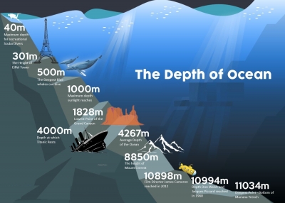
It’s beneath the surface of the Pacific Ocean to the southeast of Japan. There, you’ll find a deep, crescent-shaped trench. This is called the “Mariana Trench.” Near the southern tip of the crescent, there is a small slot-shaped area. This is the deepest point on Earth—Challenger Deep.

The bottom of Challenger Deep is about 36,000 feet below sea level. That’s nearly seven miles! This makes it the deepest known place on Earth.

The Challenger Deep is named after a British Royal Navy ship called the HMS Challenger. It was the first ship to measure the depths of what is now known as the Challenger Deep. The Marianas Trench in the western Pacific is 11,030 m deep.  

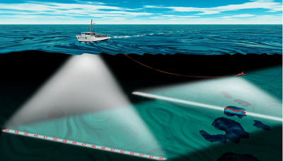
The trench was measured by “sounding.” This involves dropping a very long line with a weight at the end into a body of water. Today, scientists and researchers use sonar to study ocean depths.

Only four descents into the Challenger Deep have ever been achieved. The first was in 1960 by a vessel called the Trieste. The Trieste was a special kind of ship called a “bathyscaphe,” invented by Jacques and Auguste Piccard. The name “bathyscaphe” is taken from the Greek words for “deep” and “ship.”

Credit: WONDEROPOLIS

Picture Credit : Google

WHAT IS THE AVERAGE DEPTH OF OCEANS?

The average depth of the ocean is 3,700 meters (12,100 feet). But the deepest part ever recorded is located in the western part of the Pacific Ocean, in the Mariana Trench, at a depth of around 11,000 meters (36,200 feet).

Bathymetry is the scientific term for measuring the depth of water in oceans, lakes and rivers. Bathymetric maps are similar to land maps in that they show the different underwater landforms in a specific area. Scientists and researchers can use different methods to measure ocean depth.

The different methods are:

1. Sonar

The most common and fastest way of measuring ocean depth uses sound. Ships using technology called sonar, which stands for sound navigation and ranging, can map the topography of the ocean floor. The device sends sound waves to the bottom of the ocean and measures how long it takes for an echo to return. The “echo” is the sound wave reflecting off the seabed and returning to the sonar device.

2. Radar and satellite

Another alternative, though not as fast as sonar, is radar. Similar to sonar, radar requires sending out a type of wave that pings off an object and reflects back. The difference is that radar uses radio waves, a form of electromagnetic wave. But because electromagnetic waves travel slower in water compared with air and become diminished as they travel through water, they are more ideal for atmospheric measurements.

Ocean Depth Measured in the Olden Days

Before the discovery of using sound and radar to measure ocean depth, captains and their crews used a different way to measure the depth of the ocean. Sailors would use a tool called a lead line, which was essentially a lead weight attached to a rope that is marked every 6 feet, a length called a fathom, with a rag or strip of leather. A crew member would then throw the line into the water, and once the lead weight reached the bottom the sailor would measure and record the distance to the ocean floor using the strips on the rope.

The lead line was the most valuable method of measuring depth for navigation and has been used since the fifth century BCE. The tool helped sailors know how deep the water was and if their ship would run aground. The bottom of the lead weight was cupped inward and filled with grease and was used to bring up samples from the ocean floor to help sailors determine if the ocean bed was sand, gravel or mud.

Credit: NIST

Picture Credit : Google

CAN THE DEEP OCEAN FLOOR BE MAPPED?

Ocean floors are mapped using sound equipment and robot submarines. Sonar systems send out high -frequency pulses. The time it takes for the sound pulse to echo back from the ocean floor gives an idea as to the depth of the ocean.

Understanding the depth and shape of the seafloor, called bathymetry, is not only a mapping challenge but it is important if we are to better understand are oceans. This includes understanding ocean circulation, which affects climate, tsunamis, environmental change, underwater geo-hazards, resources, and many other processes affecting the environment, safety, and commerce.

Mapping the seafloor has been occurring since the early 19th century; however, obtaining accurate data has been a challenge until the invention of the sonar. More recent sonars (short fo  Sound Navigation and Ranging) provide far more accurate data, particularly when multibeam echosounder sonars are used.

The Seabed 2030 project is a project attempting to map the seafloor by 2030. Until now, however, only about 20% of the seafloor has been mapped using modern bathymetry methods. In part, the project to map the seafloor will benefit from crowd sourced data obtained from various ocean-going vessels.

However, NOAA is also leading the effort and vessels with sonar equipment are being used to map regions not often travelled by vessels. These vessels are equipped with the latest multibeam sonars that provide hydrographic surveying results that can then build detailed maps with about 0.5 meter resolution.

The mapping efforts are attempting to use different frequencies, from around 12 kHz to closer to 200 kHz, often used in shallower waters. While generally deeper sea levels are easier to map, as sound waves travel and allow a wider region to be surveyed as a ship passes by, shallow areas present challenges, given that multiple passes need to cover less area and interference observed from other sea life and vessels can disrupt data.

Credit: GIS LOUNGE

Picture Credit : Google

WHICH IS THE BIGGEST OCEAN?

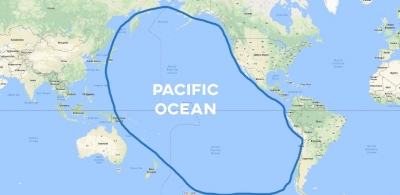
The Pacific is the biggest and the deepest Ocean. It covers a third of Earth's surface and has an area of 180 million km, holding more than 700 million km of water. It is so big that all the continents could fit within its area.

The Pacific Ocean is the largest ocean in the world, making up around 28% of the world’s surface area and almost double that in water surface area. It touches the west coast of North America. It is also home to the deepest trench on earth, the Marianas Trench, where the Challenger Deep is located. It’s 36,037 feet deep, far deeper than Mount Everest is tall. The trench is located between two tectonic plates, accounting for its incredible depth. The ocean’s coast line, along North America and Japan, is prone to earthquakes.

The ocean was named by the explorer Ferdinand Magellan. He chose “pacific” to mean “peaceful sea.” The Pacific Ocean is home to the Ring of Fire, a chain of 450 volcanoes in a u-shape. They reach from South America, along the coast of Japan, the western United States, all the way down into New Zealand. The Pacific Ocean is the world’s largest body of water.

Credit: OCEAN INFO

Picture Credit : Google

WHICH ARE THE MAJOR OCEANS?

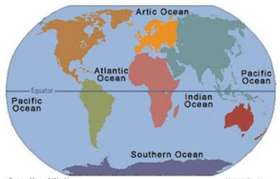
An ocean is a huge, continuous body of salt water. Oceanographers identify five major oceans on the basis of geography and the continents that surround them. These are the Pacific, Atlantic, Indian, Arctic and Southern (also known as Antarctic) Oceans. They cover about one-third of Earth's surface and contain about 97 per cent of the world's water.

Pacific Ocean

The Pacific Ocean is the largest ocean covering more than 30% of the Earth. This is close to half of the water on Earth.

It touches the west coast border of the Americas along with east Asia and Australia.

The equator divides the Pacific Ocean into two separate parts – the North Pacific Ocean and South Pacific Ocean.

Pacific means “peaceful” in Latin. It has the deepest trenches with an average depth of 3800m.

Atlantic Ocean

The Atlantic Ocean is situated between the Americas and European/African continents. The Atlantic Ocean is the second-largest and saltiest ocean in the world.

It resembles an S-shape between the Americas, Europe, and Africa. “Atlantic” originated from the Greek god “Atlas” who carried the sky for eternity.

The ocean bottom is composed of mid-Atlantic Ridge. This submarine mountain range extends all the way from Iceland to 58 degrees South latitude. It’s part of the longest mountain range in the world.

Indian Ocean

The Indian Ocean is the third largest ocean surrounding a densely populated region. It contains an additional 20% of the water on Earth’s surface.

It borders India in the North, East Africa, Australia, and the Southern Ocean. Because of the higher water temperature, it has limited marine life.

Since about 800 A.D. the Indian Ocean has played an important role in trading. For centuries, navigators have sailed along major ocean currents for shipment routes.

It is bounded by 4 tectonics plate boundaries and may include an additional plate boundary. It is the geologically youngest of the 5 oceans with spreading ridges at divergent plate boundaries.

Southern Ocean

In 2000, the Southern Ocean is the newest ocean recognized by the International Hydrographic Organization. It borders Antarctica in its entirety.

In terms of size, it’s the fourth-largest at 20,327,000 square kilometers. It extends out to 60 degrees South latitude.

It’s an extreme environment and is the least understood of the 5 oceans. This is because it is unexplored, far from populated areas, and has a severe climate.

Despite the Southern Ocean being unexplored, about 80% of all oceans in the world are unexplored. There’s still a lot of work to do for ocean exploration.

Arctic Ocean

The Arctic Ocean is the world’s smallest and shallowest ocean of all 5 oceans. Further to this, it is the coldest and least salty ocean.

In size, the Arctic Ocean is about the size of Russia. Because it’s located at the North Pole, the Arctic Ocean has polar ice. But over the years, glaciers have melted threatening sea levels to rise.

Despite the IHO recognizing it as the “Arctic Ocean”, some oceanographers still call it the “Arctic Sea”.

The Arctic Ocean is the most diverse in terms of fish species. It has a wide variety of marine species including whales, jellyfish, etc.

But because of its frigid temperatures, it has little plant life. This makes it one of the most fragile ecosystems on the planet.

Credit: EARTHHOW

Picture Credit : Google