Which Is the Longest Walkable Distance on Earth?

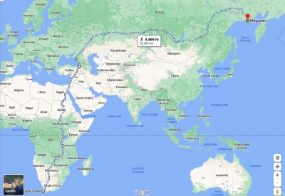
The route stretching from Cape Town, South Africa, to Magadan, Russia, 22,387 kms in length, is the world's longest walkable distance. It requires no flights or boats, just open roads and bridges. You pass through 17 countries, six time zones and all seasons of the year. The journey on this recently-discovered route has been compared to 13 trips up and down Mt Everest!

A real person walking this route at a sustainable pace would need about three years to complete the trip. They’d need to pack a variety of things or, like in the award-winning game 80 Days, sell their stuff and buy new stuff along the way: desert gear, rain gear, and even body armor for the sections through anarchic or war-torn regions like South Sudan. There’s a little bit of everything along the way, from extremely dangerous rainforest animals to near the coldest inhabited place on Earth in Russia. (Remote Bilibino, home to the smallest nuclear plant on Earth, is just a three hour flight even farther northeast after Magadan.)

People around the world do walking pilgrimages for purposes that are often spiritual. The most popular route on the Camino de Santiago, which leads to the shrine to St. James the Apostle in the Santiago de Compostela cathedral, is 500 miles long. That the hypothetical longest walk on Earth makes this daunting trip sound short is, well, blasphemous. The Appalachian Trail that runs vertically along the eastern edge of the U.S. is about 2,000 miles long, and while it’s not an explicitly religious or spiritual journey, the caretaking organization calls it a “sacred space” for its reach to people and for its preserved natural beauty.

Credit : Popular Mechanics

Picture Credit : Google 

What is ice eggs?

Ice eggs are a rare phenomenon in which small pieces of ice are rolled over by wind and water. Chunks of ice break off from larger ice sheets in the sea and wash up on shore on the incoming tide or are pushed in by gusts of wind at the water's surface. Waves strike the ice chunks as they travel, slowly eroding their jagged edges into smooth curves. Seawater sticks and freezes to the forming eggs, causing them to grow. Once the ice chunks reach the shore, the pounding waves smooth out any lingering sharp edges on their surfaces, leaving behind shiny "eggs".

Given enough time, the frozen balls can grow to become boulder size. In 2016, giant snowballs washed up on a beach in Siberia, some measuring a metre (about 3 feet) across. An ice specialist from the Finnish Meteorological Institute has been quoted as saying ice balls are rare but not unprecedented, and occur about once a year on the Finnish coastline as conditions allow. They also appear on the American Great Lakes where they are called Ice balls.

Credit : Wikipedia 

Picture Credit : Google 

What is international flower festival of Sikkim?

Sikkim's International Flower Festival held in May every year at The White Hall in Gangtok, attracts tourists from across the world. Different species of flowers are showcased in the fair.  It showcases more than 600 types of orchids, 30 types of rhododendrons, 240 kinds of trees, and an impressive array of bamboo( Bamboo grow in abundance in Sikkim and forms an integral part of the daily needs of the people here.), ferns, magnolias, roses, gladioli, cacti, alpine plants, climbers and herbs. Sikkim covers just 0.2% of India's geographical area, but is recognised for its invaluable flora and fauna, including more than 4,500 types of flowering plants and over 424 medicinal plants.

Sikkim in North East India is surrounded by lofty mountains, paddy fields and orange orchards. The considerable range of climate and altitude is responsible for the immense variation in vegetation and wild life. The natural topography and climate supports the varied flowers that row naturally in every nook and corner of Sikkim. Mention must be made of the rhododendron. There are about thirty species of the flower in Sikkim. International Flower Festival, Gangtok showcases different varieties of flower that are native to Sikkim. This festival is held during the peak flowering season in Sikkim and attracts tourist from all over India.

Credit : Indian Holiday

Picture Credit : Google 

What is the longest drive record Perseverance Mas rover has set?

NASA's Perseverance Mars rover set a new record for the longest drive in a single Martian day, travelling 245.76 metres (806 feet) on the surface of Mars on February 4. The previous record was held by NASA's Opportunity rover in 2005 (214 metres/702 feet). Perseverance broke a second record, surpassing its own longest AutoNav drive. NASA integrated this function into a rover for the first time. When in AutoNav, the rover drives autonomously by navigating through 3D maps and software that help it avoid obstacles. This feature makes Perseverance faster as compared to when it's being remotely controlled by NASA personnel; it would only traverse about 200 metres a day which would lengthen the timeline of exploration. Perseverance landed on the red planet a year ago and is on a mission to seek out signs of ancient microbial life. It has collected six samples of Martian rock and atmosphere, over 50GB of science data and has sent back over 100,000 images. It has also snapped two selfies on the Martian surface!

Picture Credit : Google 

Where are most meteorites found?

Researchers from Delft University of Technology in The Netherlands have used artificial intelligence to create a treasure map of zones in which to find meteorites hidden in Antarctic ice.

Sixty-two per cent of all meteorites recovered on Earth were found in Antarctica, making this cold continent a hotbed for space research. These meteorites provide a unique view into the origin and evolution of the solar system.

Meteorites have been accumulating in Antarctica for millennia, falling from space and becoming embedded in ice sheets within the continent's interior. As the glaciers slowly flow, the meteorites are carried with them. If a glacier comes up against a large obstacle, in areas like the Transantarctic Mountains, the ice rises and meteorites are brought to the surface. Dry Antarctic winds gradually erode the ice, exposing the meteorites. As more ice rises to the surface, the process repeats. Given enough time, a significant accumulation of meteorites builds up.

Researchers say that satellite observations of temperature, ice flow rate, surface cover and geometry are good predictors of the location of meteorite rich areas, and expect the "treasure map' to be 80 per cent accurate. Based on the study, scientists calculate that as many as 300,000 meteorites are out there on the Antarctic landscape.

Picture Credit : Google 

What is the oldest fossil flowering plant?

Researchers from Nanjing Institute of Geology and Paleontology, Chinese Academy of Sciences (NIGPAS), have uncovered the earliest example of a flower bud in a 164 million-year-old plant fossil in China.

The fossil is 1.7 inches long and 0.8 inches wide. It contains a stem, a leafy branch, a bulbous fruit and a tiny flower bud around 3 sq mm in size. The researchers have named the new species Florigerminis jurassica.

There are two main types of plants: flowering plants (angiosperms) and non-flowering plants (gymnosperms). The flower bud and fruit in the fossil are clear indicators that F. jurassica was an angiosperm, the dominant plant type during the Jurassic period. Until now, fossil evidence showed that angiosperms did not arise until the Cretaceous period, between 66 million and 145 million years ago. The discovery firmly pushes back the emergence of flowering plants into the Jurassic period, between 145 million and 201 million years ago.

Picture Credit : Google 

WHAT ARE DESERTS?

Deserts are vast and extremely dry lands, which receive very little or no rainfall. They can be both hot and cold - in both cases, the amount of evaporation is higher than the precipitation received, and the land remains very dry.

A desert is a barren area of land where little precipitation occurs and consequently living conditions are hostile for plant and animal life. The lack of vegetation exposes the unprotected surface of the ground to the processes of denudation. About one third of the land surface of the world is arid or semi-arid. This includes much of the Polar Regions where little precipitation occurs and which are sometimes called “cold deserts”. Deserts can be classified by the amount of precipitation that falls, by the temperature that prevails, by the causes of desertification or by their geographical location.

Deserts are formed by weathering processes as large variations in temperature between day and night put strains on the rocks which consequently break in pieces. Although rain seldom occurs in deserts, there are occasional downpours that can result in flash floods. Rain falling on hot rocks can cause them to shatter and the resulting fragments and rubble strewn over the desert floor is further eroded by the wind. This picks up particles of sand and dust and wafts them aloft in sand or dust storms. Wind-blown sand grains striking any solid object in their path can abrade the surface. Rocks are smoothed down, and the wind sorts sand into uniform deposits. The grains end up as level sheets of sand or are piled high in billowing sand dunes. Other deserts are flat, stony plains where all the fine material has been blown away and the surface consists of a mosaic of smooth stones. These areas are known as desert pavements and little further erosion takes place. Other desert features include rock outcrops, exposed bedrock and clays once deposited by flowing water. Temporary lakes may form and salt pans may be left when waters evaporate. There may be underground sources of water in the form of springs and seepages from aquifers. Where these are found, oases can occur.

Credit: Earth Science

Picture credit: Google

HOW DO GLACIERS SHAPE LAND?

The sheer weight and size of glaciers give them an enormous power to carve out the landscape. Much like mega bulldozers, they crush and grind everything that comes in their way, pushing the debris along until it is deposited in distinctive piles called moraine.

Glaciers are huge masses of ice that move across the land. ?Glaciers? are often called rivers of ice for the way they move down mountainsides and carve valleys. Though climate change is threatening glaciers today, there are still many glaciers changing landscapes around the world through erosion and material deposition. Glacial landforms left behind by glaciers include moraines, drumlins, troughs, aretes, horns and cirques.

There are three distinct ways that glaciers shape the land: 1) erosion 2) transportation and 3) deposition. Erosion picks up material through weathering through plucking and abrasion. That material is then transported as it moves downhill. Sometimes the material is hidden inside or at the base of the glacier, or sometimes it is on top of the glacier, accounting for the dirty color of some glaciers. Those rocks and other transported materials eventually get deposited to a new place as the glacier melts; this leftover material is called glacial till, and it's what forms many of our landscapes today from the last ice age!

Credit: labroots

Picture credit: Google

Where the first NFT rhino horn sold?

The first NFT of a rhino horn sold at an auction in South Africa, as conservationists tapped into the craze for NFTS (Non-Fungible Tokens) to raise money to protect real rhinos. Businessman Charl Jacobs paid US$6,850 for the digital horn (the actual horn was not sold), which he will place in a trust for his children. Proceeds from the sale went to the Black Rock Rhino Conservancy, home to 200 rhinos that are able to breed while protected from poachers. An NFT is a digital asset that represents real-world objects like art, music, photos, videos, etc. Its authenticity is certified by blockchain technology (a form of digital ledger) and can be bought and sold online. NFT technology allows a beneficiary to receive commissions from future sales, so if Jacobs sells his NFT, Black Rock Rhino would receive a portion of that sale.

What is StoryShots: Book Summaries app?

Can't get through your list of must-read books? Use StoryShots to learn the key takeaways of bestselling, non fiction books in minutes instead of never. Enjoy takeaways from hundreds of bestsellers; each on average 15 minutes long. Read at your own pace, listen to podcasts/audiobooks at the same time or watch an animation (if you're a visual learner) for every book in categories such as leadership, self improvement, productivity, habits, health, history, philosophy, science, mindfulness and relationships, among others. Find an interesting book? Order it on Amazon from inside the app. Free on iOS and Android for basic features, with a subscription option for extras like highlighting, offline reading, etc.

Picture Credit : Google 

What is HidrateSpark 3 device?

The HidrateSpark 3 smart water bottle tracks your water intake and reminds you to drink up. The entire bottle illuminates to remind you to drink more water at regular intervals or when you are behind on your daily water goal, and you can choose from three light patterns. It syncs via Bluetooth to the HidrateSpark app, Fitbit and Apple Health. Push notifications to your phone nudge you to keep hydrated through the day. Its smart sensors record how much you drink, calculating personal hydration goals based on your body and activity level. You can even compete with friends in fun hydration challenges. Hidrate's location tracking feature, Find My Bottle, helps you locate your bottle at the last place that it synced, ensuring that you never misplace it. A single charge of its replaceable battery lasts up to four months. The HidrateSpark 3 is made of BPA-free Tritan plastic, combined with a silicone sleeve to minimise condensation.

Picture Credit : Google 

He has the habit of smoking

I love my 17-year-old boyfriend very much, but he has the habit of smoking. I have asked him several times to stop this bad habit. He stops for a while but then starts smoking again. I even threatened to leave him if he doesn't stop. But he says that he loves me very much and will marry me and be true to me. What should I do?

You are unhappy that your boyfriend won't kick his smoking habit. So first let's reverse this: Ask yourself, if someone asked you to give up a habit of yours, would you? And if someone threatened to leave you for this habit, how would you feel? When would you give up this habit?

Trying to make a person kick a habit doesn't work unless they themselves want to and see the benefit in doing so.

Instead, ask him what makes him smoke? What satisfaction does he get by doing so? Then discuss the advantages and disadvantages smoking has on his health by asking questions and providing him with facts (do prepare). Do tell him about passive smoking too. After this, if he wants to give up, ask him if and how you can support him. Let him share ideas on what you can do- but avoid taking on the role of a policeman; no one likes to be policed even if they ask you to do it.

If he is serious about it, then create a small cwritten pact. But after that, it is his choice what he wants to do. And if he chooses to continue, and it doesn't suit you, then you need to decide what you want to do - stay or leave. If he does give up, then yay!

Picture Credit : Google 

WHAT IS AN ALPINE GLACIER?

When they form in the high mountains, these rivers of ice are called alpine glaciers. They flow down through the mountains, cutting and breaking up the rocks, creating sharp peaks, ridges and gouging out unique, U-shaped valleys.

A glacier that is surrounded by mountains is called an alpine or mountain glacier. They are a persistent body of snow that moves under its weight at a slow pace. Alpine glaciers are a sheet of snow that forms over a cirque or high rock basin. The iceberg’s uppermost layer is brittle, but the ice beneath behaves like a plastic substance flowing gently.

The glacier usually forms in a cirque or high rock basin where snow accumulates throughout the year. The most amazing fact about this glacier is that the rate of accumulation at the upper surface balances the rate of evaporation and melting at the lower end.

The glacier begins to occupy a sloping valley situated in between the creeks or steep rock walls. Following that, the accumulation of snow occurs at the upper part of the bowl-shaped depression called a cirque.

The glacial ice starts flowing downwards, slowly abrading and plucking the bedrock. The accumulation of snow that is compacting and recrystallizing is called firn.

The flow then accelerates across the steep rock where the deep crevasses or gaping fractures mark the icefall. The lower part of the glacier denotes ablation. As the ice thins, it evaporates and melts, thereby losing its plasticity. There are chances of developing fissures, as the glacier tries depositing debris at the terminus when it melts.

Credit: EARTHECLIPSE

Picture Credit : Google 

WHY ARE GLACIERS IMPORTANT?

Glaciers are a very important source of fresh water. Melting glacier ice keeps many of Earth's rivers flowing. Glaciers create fertile valleys for farming and their deposits are also rich in resources.

Glaciers are keystones of Life on Earth. As giant freshwater reservoirs, they support the planet’s life systems and influence our day-to-day lives, even for communities who live far away from them. However, glaciers are disappearing.

The disappearance of glaciers makes visible the invisible. It makes tangible the current climate change that can be hard to perceive in other ecosystems. The recent evolution of glaciers found in World Heritage sites paints a true picture of their decline in a warming planet.

A study led by Jean-Baptiste Bosson in 2019 shows that most World Heritage glaciers have lost a significant portion of their mass since 1900; some even completely disappeared, as in Africa or the Alps. The study predicts that glaciers could disappear from almost half of World Heritage sites by 2100 if business-as-usual emissions continue.

Credit: International Union for Conservation of Nature

Picture Credit : Google 

WHAT ARE FJORDS?

Fjords are very deep, long and narrow inlets with steep sides or sheer cliffs, seen along the coasts of Norway, New Zealand and Canada. A fjord is formed when the sea comes in to fill the U-shaped valley left by a glacier after it has retreated.

A fjord is a long, deep, narrow body of water that reaches far inland. Fjords are often set in a U-shaped valley with steep walls of rock on either side.

Fjords are found mainly in Norway, Chile, New Zealand, Canada, Greenland, and the U.S. state of Alaska. Sognefjorden, a fjord in Norway, is more than 160 kilometers (nearly 100 miles) long.

Fjords were created by glaciers. In the Earth's last ice age, glaciers covered just about everything. Glaciers move very slowly over time, and can greatly alter the landscape once they have moved through an area. This process is called glaciation.

Glaciation carves deep valleys. This is why fjords can be thousands of meters deep. Fjords are usually deepest farther inland, where the glacial force was strongest.

Some features of fjords include coral reefs and rocky islands called skerries.

Some of the largest coral reefs are found at the bottom of fjords in Norway. They are home to several types of fish, plankton and sea anemones. Some coral reefs are also found in New Zealand. Scientists know much less about these deep, cold-water reefs than they do about tropical coral reefs. But they have learned that the living things in cold-water reefs prefer total darkness. Organisms in cold-water reefs have also adapted to life under high pressure. At the bottom of a fjord, the water pressure can be hundreds or even thousands of kilograms per square meter. Few organisms can survive in this cold, dark habitat.

Skerries are also found around fjords. A skerry is a small, rocky island created through glaciation. Most of the Scandinavian coastline is cut into thousands of little blocks of land. These jagged bits of coastline are skerries. The U.S. states of Washington and Alaska also have skerries.

Even though skerries can be hard to get around in a boat, fjords are generally calm and protected. This makes them popular harbors for ships.

Credit:  National Geographic Society

Picture Credit : Google